You
Had
BETTER STUDY
FINAL JEOPARDY!
600
It's a non-profit organization dedicated to social, environmental, or humanitarian causes, operating independently of government, often relying on donations and volunteers.
Non-Governmental Organization (NGO)
900
 A type of map that connects areas of similar value with lines (can be elevation, or heat, etc)
What is a Isoline map
900
Some idiot puts his fingers on his arm and says "sheeesh" and this becomes a trend almost everywhere in the world that has internet access and TikTok. The idea that this diffused no matter the location or distance from the hearth because of technology can best be described by this term
What is Space time compression
900
What happens in terms of distortion to maps as the scale becomes larger
There is less distortion as you "zoom in" closer to the Earths surface
1200
Dia de los muertos combined Spanish and Aztec ideas. What kind of Diffusion happened
Stimulus
1200
All Maps have some sort of distortion. Name them
shape, size, direction, distacne
1200
refers to the process of taking pictures of the Earth's surface from satellites (or, earlier, airplanes) to provide a greater understanding of the Earth's geography over large distances.
What is Remote Sensing
1500
a geographic area the includes cultural resources and natural resources associated with the interactions between nature and human behavior
Cultural Landscape
1500
______________ is a composite statistic of life expectancy, education, and per capita income indicators, which is used to rank countries into four tiers of human development. It is organized and arranged by the ____________
Human Development index, UN
1500
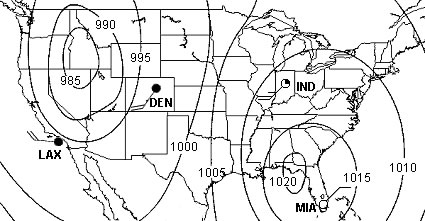
The data shown here would best be described as this type of data

What is Qualitative data
1500
These barriers to diffusion were the strongest through most of human history, but increasing technology has made them less and less relevant, especially in the last half century.
Physical Barriers