Vocabulary
Types of Maps
Latitude and Longitude Practice
Miscellaneous
200
The main directions on the compass rose.
What are north, south, east, and west?
200
If you wanted to find out where gas stations get their oil from, you would look at this type of map.
What is a resource map?
200
If you are on the point of the Earth directly on the equator, and directly on the Prime Meridian, you are standing at these coordinates.
What is 0 degrees latitude, 0 degrees longitude?
200
These lines run vertically, but measure distance east or west of the Prime Meridian.
What are lines of longitude?
400
A guide that shows what each symbol on a map stands for.
What is a map key?
400
This type of map might use different colors to represent different features of land.
What is a physical map?
400
The North Pole is located at this coordinate.
What is 90 degrees north?
400
The direction you would travel in if you flew in a plane from New Jersey to Texas.
What is southwest?
600
A guide that explains the relationship between real distances on Earth and distances on a map.
What is a scale?
600
Seen in this classroom, this type of map may use colors to illustrate which candidate won a particular election.
What is an Electoral Map?
600
The highest degree of latitude in either direction, north or south.
What is 90 degrees?
600
The highest degree of longitude in either direction, east or west.
What is 180 degrees?
800
The directions that describes the directions directly in between the cardinal directions.
What are the intermediate directions?
800
Before GPS was invented and became a feature of our phones, your older relatives would have used one of these maps to drive to their vacation destination.
What is a road map?
800
Cairo is located at these coordinates.
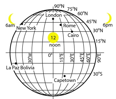
What city is located at 30 degrees north, 30 degrees east?
800
If you are in the United States of America, you are in the ____________________ and ____________________ hemispheres.
What are northern and western?
1000
The line of latitude that cuts the earth into northern and southern hemispheres.
What is the equator?
1000
A map that shows both the boundaries of states and countries, AND uses colors to show different features of the land, such as mountains and deserts.
What is a political and physical map?
1000
The correctly written coordinates if you were standing 38 degrees above the equator, and 74 degrees to the left of the Prime Meridian.
What is 38 degrees north, 74 degrees west?
1000
If you are standing at the North Pole, you are at the highest coordinate of _____________________.
What is latitude?