Regions
States& Countries
Map Skills
Vocabulary
Extra
100
Name the 4 regions in the U.S.
Northeast, Southeast, Midwest, West
100
What region is the state of NJ in?
Northeast Region
100
What is a compass rose used for on a map?
To show directions: North, South, East, and West.
100
Define: Equator.
an imaginary line drawn around the middle of the Earth that sits at 0 degrees latitude and splits the planet into the Northern and Southern Hemispheres
100
What region is California in?
West.
200
Which region is known for its humid climate?
Southeast
200
What state is the largest by area in the U.S.?
Alaska
200
What directions are measured by longitude?
North and South
200
Define: Hemisphere.
The Earth is split into two halves by imaginary lines - North and South orEast and West.
200
How are the climates of the South West and South East Regions similar?
Both can be hot and dry or hot and humid, as they are both closest to the equator.
300
Why do they call this region The Great Plains?
Flat prairie land, which is perfect for farming.
300
Which is the largest country, by area, in North America?
Canada
300
What directions are measured by longitude?
East and West
300
Define: Prime Meridian.
An imaginary line of longitude defined as 0°, running from the North Pole to the South Pole.
300
Compare a state from the Northeast Region to one from the Southwest Region. How is everyday life different? (Think: climate, population, location, recreation, etc.)
Example: New Jersey v.s. Texas
NJ is much smaller than TX,
TX climate is much hotter, all year round, than NJ
TX has far more people, but NJ is more densely populated due to its size.
400
Which regions are known for their mountain ranges and canyons?
West
400
Which is the largest country, by population, in North America?
The United States
400
When reading coordinates on a map, the numbers are measured by __________. (It is represented by a small circle.)
example: 30°N
degrees
400
Define: Contiguous.
Sharing a border, touching, or being immediately next to another state.
400
Name the National Park that is technically a part of 3 states and which region it is in.
Yellowstone nation Park - West Regions (Wyoming/Montana/Idaho).
500
How does the climate and natural resources of the Midwest make it ideal for farming.
The weather and land make a great environment for planting and growing crops.
500
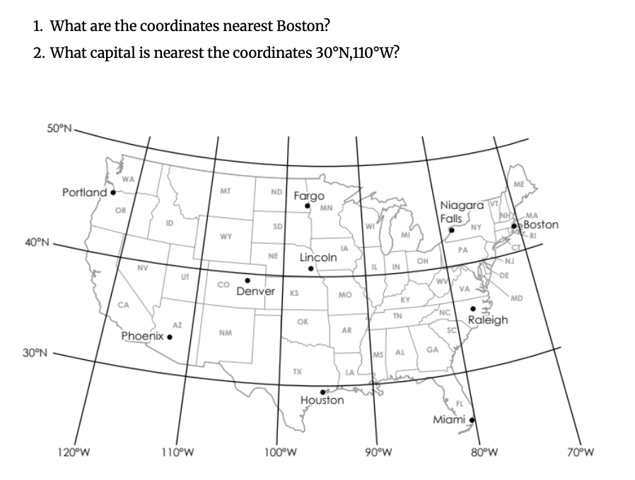
1. 40°N,70°W
2. Phoenix, AZ
500
When stating/writing coordinates on a map, which should be listed first - longitude or latitude?
latitude (north and south).
500
What is the difference between Relative Location and Absolute Location?
Absolute location is an exact, fixed point on Earth, while relative location describes where a place is by comparing it to other landmarks.
500
What does Topography mean?
the shape of the land, including hills, mountains, valleys, and flat areas.