Map Skills 1
Map Skills 2
Continents 1
Continents 2
Oceans
100
What are the 4 directions on a compass?
North, south, east, and west.
100
What is the imaginary line located at 0 degrees latitude?
Equator
100
How many continents are there?
7
100
Which continent do we live on?
North America
100
How many oceans are there?
5
200
What direction do lines of latitude run?
East to west
200
What direction do lines of longitude run?
North to south
200
What is the smallest continent?
Australia
200
What is the biggest continent?
Asia
200
Which ocean is the coldest?
Arctic Ocean
300
Which city is located at 33 degrees N latitude and 112 degrees W latitude?
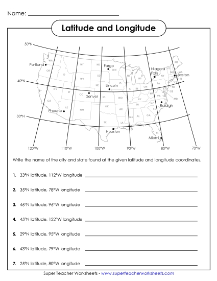
Phoenix
300
Which city is located at 29 degrees N latitude and 95 degrees W longitude?
Houston
300
What continent is shown in the picture?
Africa
300
In which continent would you find this landmark?
Europe
300
Which two oceans border the United States?
Atlantic and Pacific Oceans
400
What does a map scale tell you?
How a unit of measurement on a map relates to distance in real life.
Example: one inch on a map = 1 mile of a city in real life
400
What is the imaginary line located at 0 degrees longitude?
Prime Meridian
400
On which continent would you find this landmark?

South America
400
What continent is shown in the picture?
South America
400
Which ocean is shown in the picture?

Indian Ocean
500
What hemisphere is North America located in?
The northwest hemisphere
500
Why can it be 3pm in Lake Geneva and 10pm in Germany at the same time?
Time zones
500
On which continent would you find the Outback?
Australia
500
On which continent would you find the volcano Mount Erebus?
Antarctica
500
Which ocean does Antarctica border?
Southern Ocean