Vocabulary
Longitude/Latitude
Land/Geography
Climate
100
The study of earth
Geography
100
The equator is at ___ degrees latitude.
0
100
Geography can help explain why mountains make it difficult for people to ___________.
Move from place to place
100
How is the climate in Antarctica compared to Florida?
Colder
200
Spherical model of Earth
Globe
200
The _______ is at 0 degree longitude.
Prime Meridian
200
The ______ Mountains stretch about 3,000 miles from northwestern Canada to New Mexico.
Rocky
200
The types of plants found in an area are called the ___________.
Vegetation
300
Patterns of weather
Climate
300
A location's longitude and latitude numbers and directions are called _________
Coordinates
300
The largest river in the nation is the _________ river.
DOUBLE POINTS FOR CORRECT SPELLING
Mississippi
300
People are more likely to build their homes on ____ ____ than steep mountain ranges.
Flat land
400
Feature of Earth's land surface
Landform
400
State borders may follow physical features or lines of ________ and ________
Longitude and Latitude
400
The ____ _______ forms much of the U.S. border with Mexico.
Rio Grande
400
Many people live near oceans, gulfs, or lakes because water can provide food and support _____.
Trade
500
Group that deals with laws
Government
500
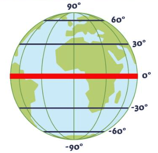
Equator
500
What's one way geography can affect how people live?
Climate, how you travel, crops, etc.
500
Areas with rain and ____ temperatures can be good for growing _____.
Warm, crops
600
Lines on a globe going up and down
DOUBLE POINTS
Longitude
600
Is Illinois above or below the equator?
Above
600
A physical feature is any _____ or body of ______ that is part of Earth's surface
Landform, water
600
An area's climate can be affected by landforms, bodies of water, and ________.
Latitude
700
Lines on a globe going side to side
Latitude
700
Is Argentina above or below the equator?
DOUBLE POINTS
Below
700
The largest area of plains in the U.S. is the _____ _______, located in the Midwest.
TRIPLE POINTS
Great Plains
700
Climate maps can be made using measurements of temperature over _____ or _____.
Months, Years
800
Types of plants in an area
Vegetation
800
What is the difference between longitude and latitude?
Longitudinal lines = up and down
Latitudinal lines = side to side
800
The word "geography" comes from Greek words meaning "_____" and "______".
Earth, describing
800
Climate describes aspects of weather measured over a long period of time, including ___________, ________, and ____.
100 POINTS PER ANSWER
Temperature, rainfall, climate
900
North, East, South, and West
TRIPLE POINTS
Cardinal Directions
900
An area's _____ can be affected by landforms, bodies of water, and latitude.
Climate
900
________ maps use data about how many _______ live in an area.
Population, people
900
How can climate affect where people live?
Areas with rain and warm temperatures are easier to live in compared to deserts/tundras.
1000
Landmass or body of water on Earth
Physical Feature
1000
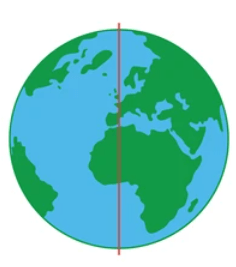
Prime Meridian
1000
The ________ Mountains stretch from Canada to Alabama and are the largest mountain range in the eastern U.S.
DOUBLE POINTS FOR CORRECT SPELLING
Appalachian
1000
How can physical features affect how people live?
People would rather live on flat land, near water for crops/trade, etc.