Landforms and Landscapes
Volcanoes and Volcanic Hazards
Earthquakes and Tectonic Hazards
Urbanisation and Changing Nations
Topographic Mapping: Directions, Scale and Relief
Latitude and Longitude
Geography Wildcard
100
What is a landform?
A natural feature of the Earth’s surface, such as a mountain, beach, river or cave.
100
What is a volcano?
An opening in the Earth’s crust where magma, gas and ash can escape.
100
What is an earthquake?
A sudden shaking of the ground caused by movement in the Earth’s crust.
100
What is urbanisation?
The increase in the percentage of people living in towns and cities.
100
What is a topographic map?
A detailed map showing physical and cultural features, including relief/height, vegetation and drainage.
100
What is the name of the line of latitude at 0°?
The Equator.
100
What is a natural hazard?
A natural event that can cause harm to people (social), property (economy) or the environment.
200
What is the difference between a landscape and a landform?
A landscape is a large area with many features; a landform is one specific natural feature.
200
What is the difference between magma and lava?
Magma is molten rock below the surface; lava is molten rock after it reaches the surface.
200
What are tectonic plates?
Large pieces of the Earth’s crust that move slowly over the mantle.
200
What is the difference between urban and rural areas?
Urban areas are towns/cities; rural areas are countryside/farming or less populated areas.
200
What direction is directly opposite north-east?
South-west.
200
What is the name of the line of longitude at 0°?
The Prime Meridian.
200
What does FIFO stand for?
Fly-in fly-out.
300
Name two coastal landforms.
Beach, sand dune, cave, arch, stack, cliff, headland, bay.
300
Name the four main layers of the Earth.
Crust, mantle, outer core and inner core.
300
What type of plate boundary is linked to plates sliding past each other?
Transform boundary.
300
Give two push factors that may cause people to leave rural areas.
Lack of jobs, poor services, drought, poverty, limited education or healthcare.
300
What does a contour line show?
Places of equal height above sea level.
300
Do lines of latitude run east-west or north-south?
East-west.
300
What is internal migration?
Movement of people within the same country.
400
What is erosion?
The wearing away and movement of rock, soil or sand by water, wind or ice.
400
What type of plate boundary often creates volcanoes when one plate sinks beneath another?
A convergent plate boundary/subduction zone.
Half points: if oceanic and continental crust not both named and have their differences described.
400
What is the focus of an earthquake?
The point underground where the earthquake begins.
400
Give two pull factors that may attract people to cities.
More jobs, better education, healthcare, transport, entertainment or services.
400
What does it mean when contour lines are very close together?
The land is steep.
400
Do lines of longitude measure distance east/west or north/south of the Prime Meridian?
East or west of the Prime Meridian.
400
What is international migration?
Movement of people from one country to another.
500
What is deposition?
When transported material such as sand, sediment or rocks is dropped in a new place.
500
What is a hotspot volcano?
Extra 100 points for an example.
A volcano formed away from a plate boundary where magma rises through the crust.
500
What is the epicentre of an earthquake?
The point on the Earth’s surface directly above the focus.
500
Why do secondary and tertiary industries often cluster in cities?
Cities have more workers, customers, transport, services, infrastructure and businesses nearby.
500
What is the difference between a 4-figure area reference and a 6-figure grid reference?
4-figure AR locates the gride square; 6-figure GR gives a more precise location within the square.
500
Which coordinate comes first: latitude or longitude?
Latitude comes first (S/N), then longitude (E/W).
500
What is the difference between prevention, mitigation and preparedness?
Prevention tries to stop harm occurring, mitigation reduces harm, preparedness gets people ready before a hazard.
600
Explain how a coastal arch can eventually become a stack.
Waves erode cracks in a headland to form a cave, then an arch. The arch roof collapses, leaving a stack.
Half points if you don't mention or explain hydraulic action.
600
Name one social, one environmental and one economic impact of a volcanic eruption.
Social: deaths/injuries/evacuation. Environmental: ash/lava destroys habitats. Economic: damage to homes, farms, roads or tourism.
Half points if one category is incorrect.
600
Give two reasons why earthquakes can cause major damage in cities.
High population density, tall buildings, weak infrastructure, roads/bridges collapsing, fires, broken water/gas lines.
600
Give one social, one environmental and one economic consequence of urbanisation.
Social: overcrowding/isolation. Environmental: pollution/loss of habitats. Economic: more jobs but inequality between regions.
Half points if one category is incorrect.
600
The map scale is 1:100000 cm. How far is 4 cm in real life?
4 km, or 4000 m.
600
100 points for each correct response (1-5) - extra 100 points if all 5 are correct.
100 points for each correct response (1-5) - extra 100 points if all 5 are correct.
1 - equator
2/3 - north/south poles
4/5 - tropics cancer / capricorn
600
Roughly how many megacities are there now compared to 1950? Bonus 100 points if you can name the mega cities from 1950. Another bonus 100 points if you can name the closest mega city to Australia.
Roughly 33 megacities now. 2 in 1950.
First 2 - New York & Tokyo.
Closest megacity to Aus - Jakarta.
700
Why can different rock types create different landforms in the same landscape?
Softer rock erodes faster, while harder rock resists erosion, creating uneven features such as cliffs, caves, arches and stacks.
700
Why might a volcanic eruption be worse in a poorer country than a richer country?
Bonus 100 points if you state what we have referred to 'poorer and richer' countries as throughout the term.
Poorer countries may have weaker buildings, fewer warning systems, less emergency planning and fewer resources to recover.
700
Explain why two earthquakes with the same magnitude might have very different impacts.
Impacts depend on depth, distance from cities, building quality, population density, preparedness, wealth and emergency response.
Minus 200 points if explanation is not detailed enough or doesn't compare two different earthquakes enough.
700
How can international migration reinforce urban concentration in Australia?
Migrants often settle in major cities because of jobs, universities, family networks, services and cultural communities.
700
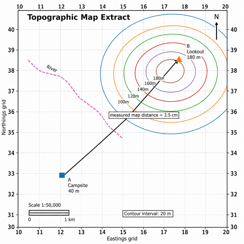 200 points for answering each of the following.
- The real-world distance from A to B.
- The main compass direction travelled.
- Whether the walker is mostly travelling uphill or downhill.
100 extra for all 3.
The map distance is 3.5 cm on a 1:50,000 map. This means the real-world distance is 1.75 km. The walker travels mainly north-east. They are travelling uphill, from about 40 m to 180 m.
700
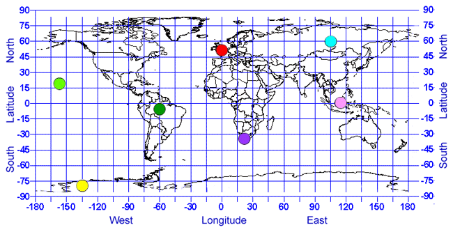
Can you please correctly state and match the continents with the most northern/southern/western and eastern labelled positions on the map above. 100 points each - 500 if you do all 4. 200 points more for stating rough coordinates for Perth.
North - teal dot (Asia - siberia)
western - light green dot (Pacific ocean - Ha'waii)
Eastern - pink (SEA - Borneo - Malaysia/Indonesia)
Southern - yellow (antartica)
Perth coodinates - 31.9535° S (latitude) and 115.8570° E (longitude). [1]
700
A city is growing quickly, but roads, housing and services cannot keep up. Explain one likely social and one likely environmental problem.
Social: overcrowding, inequality, housing stress or poor services. Environmental: pollution, waste, habitat loss or pressure on water supplies.
Minus 400 points if only one problem is correct. Needs sufficient detail for full points.