Break It Down
5 Themes of Geography
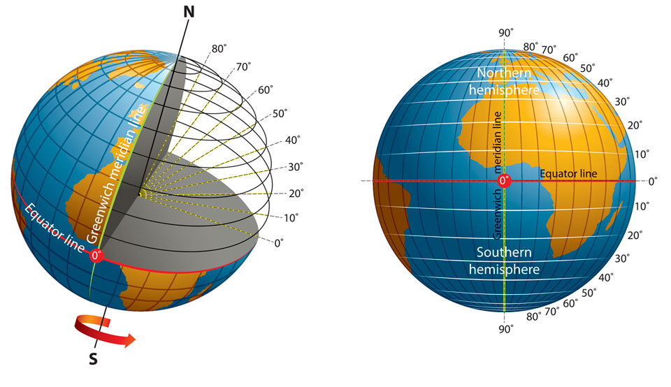
Invisible Lines
All Over the Map
Your World Now
200
one-hundredth
centi-
200
the spot on Earth where a place is located, often using coordinates of latitude and longitude.
(Starts with 'L')
Location

200
these invisible lines run parallel to the equator
latitude
*FACT: Latitude runs East to West, but MEASURES the distance between North and South.
200
the symbol featuring the cardinal directions, and, sometimes, the intermediate directions.
compass rose

200
the third most populous country in the world. HINT: Don't think too hard about it.
United States
400
sun
sol-

400
this examines how humans adapt to, modify, and depend on their environment.
(Answer is basically given)
human-environment interaction
400
these invisible lines run from Pole to Pole and measure distance from east or west of the Prime Meridian
Longitude
FACT: Longitude runs north and south, but MEASURE east to west

400
the type of map shows human-made features such as boundaries, countries, states, and cities.
political map

400
the number of oceans most countries recognize.
five

500
people
demos-

500
grouping places that share similar characteristics, such as climate, culture, or language
Region
500
This invisible line is opposite the Prime Meridian. HINT: Think of the prefix that means "against." (There's 2 potential answers to this)
Antimeridian -or- the International Date Line
The International Date Line is the line of separation between two dates.

500
a person who makes maps
cartographer
500
the youngest country in the world.
HINT: It's in Africa
South Sudan

600
place
topo-

600
the ways in which people, goods and ideas travel from one location to another.
(Starts with a 'M')
Movement

List examples of how people, goods and ideas are moved.
600
this invisible line runs from the North and South Poles and is the starting point for measuring longitude.
Prime Meridian (0° W)

600
when transferring Earth's surface to a flat map, this process can cause shapes, areas, distances or directions to be inaccurate.
distort

600
the second largest continent if you believe there are only 7 continents.
Africa
700
earth
geo-
700
the physical and human characteristics that make a location unique.
(Starts with a 'P')
Place
700
this invisible line divides the Earth into the Northern and Southern hemispheres.
equator
700
map feature that shows the relationship between the distances on the map and the actual distances on Earth.
scale

700
4, 5, 6, or 7? Different countries see the number of __________ differently.
Continents
