A RADAR return is called this.
Echo
This type of Satellite rotates in the same direction as the earth and is fixed in space.
Geostationary
This is the Formal Two Letter Identifier for an Upper Wind Chart
FB
Environment Canada Produces these "big picture snapshots" on these 4 Zulu Times
00Z, 06Z, 12Z, 18Z
In Canada, this is the preferred unit of Pressure measurement
Hectopascals hPa
The different angles a RADAR beam can be set to is called this.
Tilt
Geostationary Satellites provide updated consistent views of the earth in this cycle of time
15 minutes
These are the reported altitudes for Low Level Upper Winds.
3000, 6000, 9000, 18,000 feet
A "flag" depicting Wind direction and Wind Speed is called this.
A Wind Barb
The approximate altitude that a 850 hPa chart portrays.
5000 feet
The acronym RADAR stands for this.
Radio Detection and Ranging
Polar Orbiting Satellites orbit in this directional path
North to South
The reason an Upper Wind Report would not be given for the 3000' level.
Terrain elevation is more than 1500' ASL
This type of front is noted as "QS"
Quasi Stationary
Contours on a Constant Pressure Chart depict this.
Height of the Pressure Level
The scattering, reflection, or absorption of a RADAR beam close to a station, or in areas of intense precipitation resulting in unreliable data is called this.
Attenuation
According to "Canadian Weather Aviation", an intense low pressure system in the summer often appears as this type of cloud
Comma Cloud
The code for light and variable winds less than 5 knows
9900
This Law states that "If you stand with your back to the wind, the low pressure is on the left."
Buy's Ballots Law
This is the unit of measurement representing pressure level heights.
Decameters
Reflectivity depends on these two characteristics of precipitation.
Intensity and type
In Satellite Weather Forecasting, this term describes forecasting weather within the next 6 hours.
Nowcasting.
Is the decoded answer to this Upper Wind Report:
"8060"
300 Degrees at 160 Knots
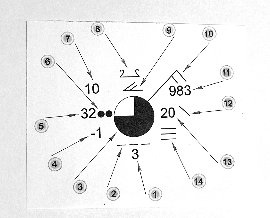
Is the Barometric Pressure for this Surface Station Plot.

1098.3 hPa
This is what the winds are called when the Pressure Gradient Force equals the Coriolis Force
Geostrophic