Airspeed Limitations
Speed Limits
Altitudes
Weather Services
VFR Cruising Altitudes/weather minimums
100
Va?
Design maneuvering speed. If rough air/turbulence, reduce to maneuvering speed or less to minimize stress on the plane.
100
Unless otherwise authorized, what is the maximum indicated airspeed at which a person may operate an aircraft below 10,000 feet MSL?
A) 200 kts
B) 250 kts
C) 288 kts
B) 250 kts max airspeed below 10,000 ft MSL

100
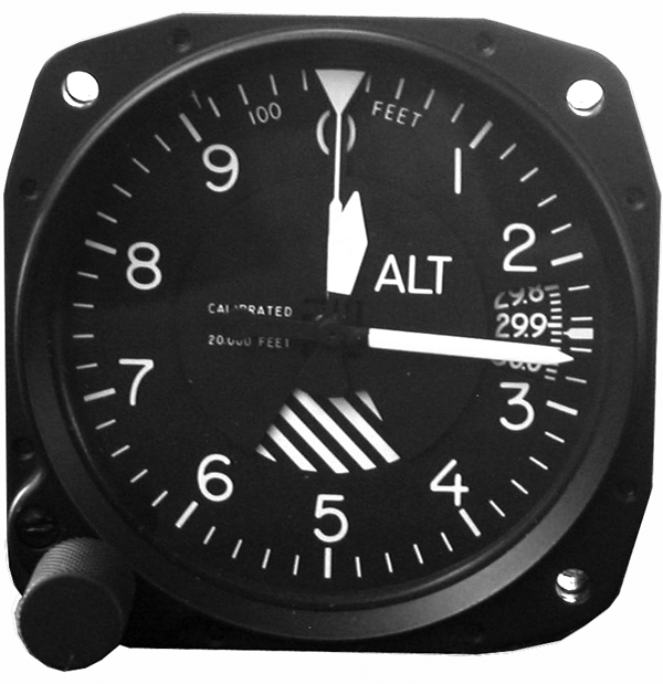
Indicated Altitude?
Read on altimeter after set to current local altimeter setting.
100
When the term "light and variable" is used in reference to a winds aloft forecast, the coded group and windspeed is
A) 0000 and less than 7 knots
B) 9990 and less than 5 knots
C) 9999 and less than 10 knots
B) 9990 and less than 5 knots
100
Which cruising altitude is appropriate for a VFR flight on a magnetic course of 135 degrees?
A) Even thousandths.
B) Even thousandths plus 500 feet
C) Odd thousandths plus 500 feet
C) Odd thousandths plus 500 feet

200
Vfe?
Maximum flap extended speed (upper limit of white arc). Entire white arc is flap operating range.
200
Maximum indicated airspeed aircraft may be flown when at or below 2,500 feet AGL and within 4 nautical miles of primary airport of Class C airspace is?
A) 200 kts
B) 230 kts
C) 250kts
A) 200 kts
at or below 2,500 feet AGL and within 4 nautical miles of primary airport of Class C airspace
200
Absolute Altitude?
Height above surface.
200
What should pilots state initially when telephoning Flight Service for preflight weather information? Also what info is needed?
A) Tell number of occupants on board
B) Identify themselves as pilots
C) State their total flight time
B) Identify themselves as pilots
Flight type: VFR/IFR
Intended route, destination, type of aircraft
Request standard briefing to get complete weather briefing
Abbreviated briefing- supplement mass disseminated data or only one or two items needed
Outlook briefing when proposed departure time is 6 or more hours from time of briefing.
200
Which VFR cruising altitude is appropriate when flying above 3,000 feet AGL on a magnetic course of 185 degrees?
A) 4,000 ft
B) 4,500 ft
C) 5,000 ft
B) 4,500 ft
300
Vs1?
Stall speed or minimum steady flight speed in a specified configuration (lower limit of green arc). Entire green arc is normal operating range.
300
When flying in airspace underlying Class B airspace, maximum speed authorized is?
A) 200 kts
B) 230 kts
C) 250 kts
A) 200 kts airspace underlying Class B airspace
300
True Altitude?
True height above mean sea level (MSL) normally measured in feet.
300
AIRMETS?
A) Information on weather that may be hazardous to all pilots. Covers moderate icing/turbulence, winds 30+ knots at surface, IFR conditions, mountain obscurement.
B) Weather potentially hazardous to ALL aircraft. Covers severe icing, severe turbulence, (sand, dust, volcanic ash) storms.
C) Weather development such as tornadoes, thunderstorms
A) Information on weather that may be hazardous to all pilots. Covers moderate icing/turbulence, winds 30+ knots at surface, IFR conditions, mountain obscurement.
300
Minimum distance from clouds required for VFR operations on an airway below 10,000 feet MSL is?
A) Remain clear of clouds
B) 500 ft below, 1,000 ft above, 2,000 ft horizontally
C) 500 ft above, 1,000 ft below, 2,000 ft horizontally
B) 500 ft below, 1,000 ft above, 2,000 ft horizontally
Includes Class B, C, D,E below 10,000 ft MSL
400
Vso?
Stall speed or minimum steady flight speed in the landing configuration (lower limit of white arc).
400
When flying in a VFR corridor designated through
Class B airspace, maximum speed authorized is?
A) 180 knots
B) 200 knots
C) 250 knots
B) 200 knots
VFR corridor designated through
Class B airspace
400
Pressure Altitude?
Altitude indicated whenever altimeter is set to 29.92.
Standard datum plane where air pressure= 29.92 inches of mercury.
At, above, or below sea level
400
SIGMENTS?
A) Information on weather that may be hazardous to all pilots. Covers moderate icing/turbulence, winds 30+ knots at surface, IFR conditions, mountain obscurement.
B) Weather potentially hazardous to ALL aircraft. Covers severe icing, severe turbulence, (sand, dust, volcanic ash) storms.
C) Weather development such as tornadoes, thunderstorms
B) Weather potentially hazardous to ALL aircraft. Covers severe icing, severe turbulence, (sand, dust, volcanic ash) storms.
400
More than 1,200 ft AGL, but less than 10,000 ft MSL, minimum flight visibility for day VFR? Night?
A) 1 mile
B) 3 miles
C) 5 miles
A) 1 mile visibility for day
3 miles visibility for night
500
Vne?
Never exceed speed (red radial line)
500
At or above 10,000 feet MSL?
A) No speed limit
B) 250 knots
C) 200 knots
A) NO speed limit
500
Density Altitude?
Pressure altitude corrected for nonstandard temperature and/or pressure.
500
Convective SIGMENTS?
A) Information on weather that may be hazardous to all pilots. Covers moderate icing/turbulence, winds 30+ knots at surface, IFR conditions, mountain obscurement.
B) Weather potentially hazardous to ALL aircraft. Covers severe icing, severe turbulence, (sand, dust, volcanic ash) storms.
C) Weather development such as tornadoes, thunderstorms
C) Weather development such as tornadoes, thunderstorms
500
AIRSPACE REVIEW
