Map Projections / Scale
Regions
Data Systems
Types of Maps
Misc.
100
What do all map projections share?
Distortion
100
A pizza delivery area is best described as a ______ region.
Functional
100
What is the geographic tool that uses a network of satellites to determine absolute location?
GPS
100
What type of map has different size shapes to illustrate frequency of occurrence?
Graduated Symbols
100
What is the geographic concept that describes the relative size of the globe as becoming much smaller due to advancements in transportation and communication?
Time Space Compression
200
What type of map projection is this?

Gall-Peters
200
Identify one example of a perceptual region that can be found in the United States.
The South, The midwest, the Rust Belt, the Sun Belt, The bible belt etc.
200
Name 2 types of remote sensing data collection tools
satellites, aircraft photographs, drones, aircraft sensors
200
What type of map is this?
Isoline
200
This term refers to characteristics of a place including landform, climate, and natural resources
Site
300
What is the scale of analysis for a map showing literacy rates for countries across the globe?
National Scale
300
What is a node, and what types of regions have a node?
A node is a center point that connects everything in a functional region
300
What type of qualitative and quantitative data do they collect at a doctors appointment?
Qualitative- How do you feel, symptoms, etc.
Quantitative- height, weight, temperature
300
What type of map projection is this?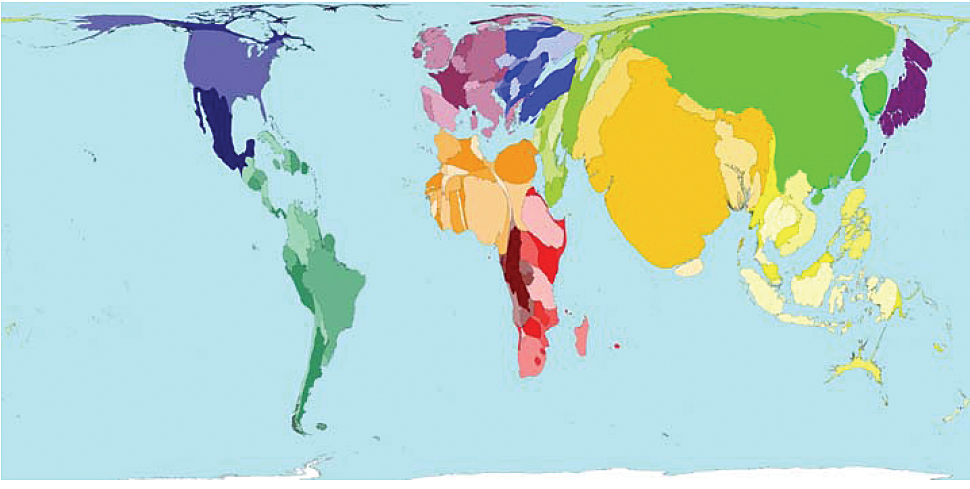
Cartogram Map
300
The belief that the physical environment plays a role in the development of society along with the culture.
Environmental Determinism
400
An advantage of this type of map projection is that it is accurate for navigation, but it significantly distorts area (size).
Mercator Projection
400
What type of region includes the political boundaries within a country, like states in the United States?
Formal Regions
400
Define the Term GIS
GIS is a technology that is used to create, manage, analyze, and map all types of data in LAYERS.
400
What type of map is this?
graduated symbol
400
Name one trend that attempts to address sustainability
Answers may vary
500
Which map would show more detail; a map at 1:20,000 scale or a map at 1:200,000 scale?
A map at 1:20,000 scale
500
Radio stations are ________ regions; as you move further away, people will start to tune the station out due to_____.
Functional; distance decay
500
The __________ collects data on the population in the United States every 10 years.
U.S. Census
500
What type of map uses colors or different shades to illustrate frequency of occurrence?
Choropleth
500
Multinational corporations like Mcdonalds or Apple, and the spread of information through social media apps are all examples of what concept?
Globalization