Map Projections
Map Types
Diffusion
Models
Models pt. 2
100
the system used to transfer locations from Earth's surface to a flat map
What is projection?
100
shows common features such as boundaries, roads, and mountains
What is a reference map?
100
spread of the black plague
What is an example of contagious diffusion?
100
used to represent the process of explaining the transformation from a pre-industrialized to an industrialized economy; Warren Thompson
What is the Demographic Transition Model (DTM)?
100
demonstrates the global division of labor, which consists of multiple interconnected states divided into three tiers; Immanuel Wallerstein
What is the Core-Periphery Model?
200
used for navigation
accurate directions, parallels & meridians meet at the correct angles
distance b/t latitude and longitude appears constant, landmasses near the poles appear large
What is the Mercator Projection?
200
a thematic map that uses tones or colors to represent spatial data as average values per unit area
What is a chloropleth map?
200
hip hop music spreading from inner cities to the suburbs in the United States
What is an example of (reverse) hierarchical diffusion?
200
connects the prevalence of certain types of diseases to stages of the DTM; Abdel Omran
What is the Epidemiological Transition Model (ETM)?
200
discussed agricultural location as primarily a factor of transportation cost and profit maximization by farmers prior to modern industrialization
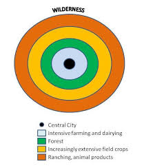
What is the Von Thünen Model?
300
the map projection commonly found in textbooks
lines of latitude are parallel and lines of longitude meet at the poles
relatively low levels of distortion throughout the map
What is the Robinson Projection?
300
uses dots to show the specific location and distribution of something across the territory of a map
What is a dot density map?
300
the migration of Christianity with European settlers who came to America
What is an example of relocation diffusion?
300
classic liberal model; postulates that economic modernization occurs in five stages
What is Rostow's Modernization Model?
300
demonstrates how American urbanization can be categorized into four distinct periods, impacted and expanded by a particular transportation technology
What are Borchert's epochs?
400
shows all areas according to their actual size
parallels & meridians meet at perpendicular angles
displays all countries in their true size & location
What is the Peters Projection?
400
uses lines that connect points of equal value to show data variation across space
What is an isoline/isometric map?
400
Chinese porcelain was wildly popular in Europe, but extremely difficult to transport over large distances; this led to Europeans developing their own version of porcelain with distinctly European designs
What is an example of stimulus diffusion?
400
the price and demand for real estate changes (usually decreases) as distance from the CBD (or market) increases; William Alonso
What is the Bid-Rent Theory?
400
the resource-rich, land-based "pivot area" would be key to world dominance
What is the Heartland Theory?
500
projection used by airline pilots
has straightest direction
shows Earth as viewed from the poles
What is the Polar/Azimuthal Projection?
500
uses space on the map to show a particular variable
What is a cartogram?
500
a ski shop in Utah opening a location in Miami
What is an example of maladaptive diffusion?
500
the US urban area consists of an inner city surrounded by a large suburban residential and business areas tied together by transportation nodes; Chauncy Harris
What is the Galactic City/Periphery Model?
500
designed to explain the spatial distribution of human settlements
What is the Central Place Theory?