Location/Data
Maps/Place
Movement
HEI
Region/Scales of Analysis
100
Spatial data tells us about the ______ and ________ of geographic features.
Location and Shape
100
What is map projection?
The method used to present a part of the earth on a flat surface
100
This term refers to the process by which a feature, idea, or innovation spreads across space from one place to another over time
Diffusion
100
Human-environment interaction revolves around which principles? (List 2)
Land-use, sustainability, environmental determinism, possibilism
100
What is a region? What are the three types of regions?
an area or division, especially part of a country or the world having definable characteristics; formal, functional, perceptual
200
Define Location
A specific point on earth's surface
200
What are the four ways maps can be distorted?
Distance, direction, size/area, shape
200
Billions of dollars of goods move each day across the Pacific Ocean between China and the U.S. This is an example of international ______.
Flows
200
The idea that human decisions, not just the environment, shape societies
Possibilism
200
The service area of DoorDash in your town would be an example of this type of region.
Functional Region
300
Combining census data with maps to analyze patterns is an example of this tool.
GIS
300
This describes the physical characteristics of a place, including its landforms, climate, and resource availability, such as Sydney being located along a harbor
Site
300
TikTok videos created in South Korea are watched almost instantly in the United States, making Seoul feel “closer” to Chicago. This describes what concept?
Time-Space Compression
300
Why is environmental-determinism considered and outdated idea or a "stepping stone" towards other, more modern ideas?
Ignores culture and environmental modification
300
People in the U.S. might disagree about where “the South” begins and ends. This shows the nature of this kind of region.
Perceptual/Vernacular Region
400
Why is interpreting data important? What kinds of decisions does it help us make?
Personal, business, governmental
400
Singapore has limited land and natural resources, yet it has become one of the world’s busiest trade hubs because it lies along major shipping routes between the Indian and Pacific Oceans.
This describes Singapore’s ______.
Situation
400
What factors may influence the movement of people from one place to another?
Job opportunities, money, education, resources
400
Floating solar farms in Portugal exemplify which geographical concept? How do they do so?
Generating clean energy to meet present needs while reducing reliance on fossil fuels. This ends up protecting the environment for future generations
400
What is the scale of analysis of this map? 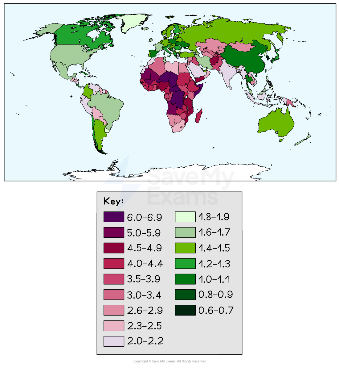
National
500
New Orleans is located at 30° N, 90° W. It is also described as being near the mouth of the Mississippi River, making it a key port city for trade.
This example illustrates both of these geographic concepts.
Absolute and Relative Location
500
The Mercator projection has been criticized for reinforcing this specific worldview because it makes powerful northern countries like Greenland and Europe appear disproportionately larger and more dominant than they actually are.
Eurocentric
500
Before online shopping, people were more likely to buy clothes from a nearby store rather than one several states away. Today, companies like Amazon allow shoppers to easily purchase items from across the country. This shift shows how technological change has weakened what geographic principle?
Distance Decay
500
This term refers to how people organize and change the land around them for various purposes, such as farming, building cities, or transportation, and is demonstrated by the practice of rice terracing in the Philippines.
Land Use
500
What is this map's scale of analysis?
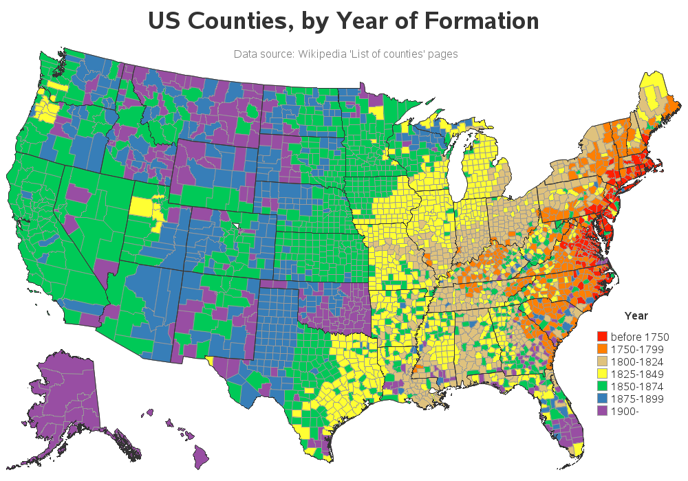
Local