BASICS
FACTORS AFFECTING TEMPERATURE
MAPS AND GRAPHS
SOURCES OF RAINFALL
IMPACTS
10
Which climatic zone includes Karachi?
Coastal/humid climatic zone.
10
State the general rule of the relationship between altitude and temperature
For every 1000m rise in the altitude of land above the sea level, 6.5-100C temperature decreases
10
What does a line graph usually represent on a climate graph?
Temperature.
10
What type of rainfall forms when moist air rises over mountains?
Relief rainfall.
10
Name two health problems caused by extremely high temperatures.
1) Dehydration;
2) Heatstroke.
3) Skin cancer
20
Name two characteristics of Pakistan's highland climate.
1) Cool summers
2) Very cold winters
3) 500-750+mm precipitation, often with snowfall.
20
What is the moderating influence of the sea on temperature called?
Maritime effect / oceanic influence.
20
What do the vertical bars represent on a climate graph?
Rainfall (mm).
20
Which weather systems bring winter rainfall and snowfall to Western Pakistan?
Western depressions / western disturbances.
20
Name two agricultural problems caused by low rainfall.
1) Crop failure;
2) Shortage of irrigation water.
30
What happens to the temperature and precipitation when we go from South to North in Pakistan?
1) Temperature decreases
2) Precipitation increases
30
Why does cloud cover reduce daytime temperatures but increase nighttime temperatures?
1) Blocks incoming sunlight;
2) traps outgoing heat.
30
Label the Climatic zones
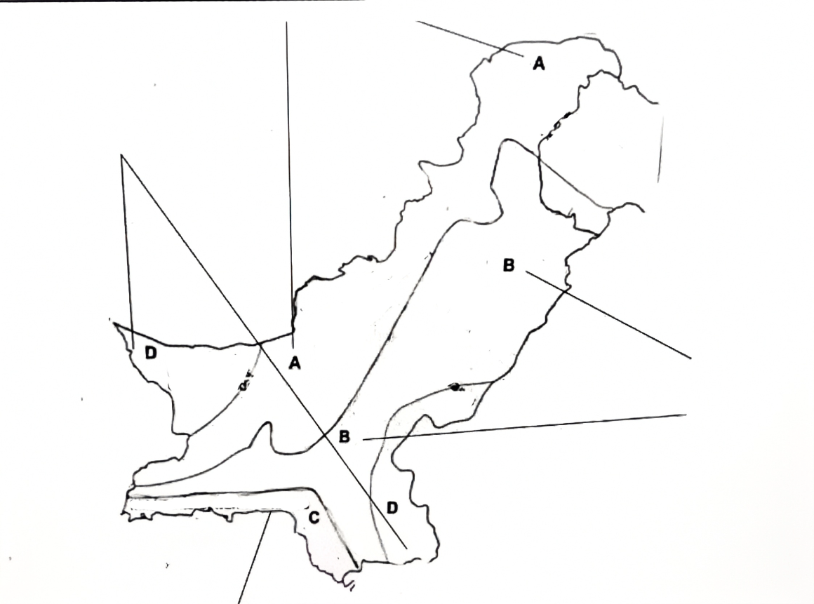
A) Highland
B) Lowland/ Semi-arid
C) Humid/Coastal
D) Arid
30
How does a temperature inversion layer prevent convectional rainfall?
Warm air above traps cooler air below, preventing vertical uplift and cloud formation. Moisture is trapped in criss-cross system of winds
30
Name two ways extremely low temperatures affect transport and telecommunications.
1) Roads blocked by snow;
2) Communication lines damaged by ice - connectivity/network problems
3) visibility issue during blizzards
40
Name two climatic characteristics of the lowland (semi-arid) zone.
1) Hot summers;
2) Low to moderate rainfall. (250-500mm)
40
Why does Lahore experience a greater annual temperature range than Karachi?
1) Continental effect in Lahore;
2) Maritime influence in Karachi.
40
Q Study Fig., which shows the climate of Gilgit.
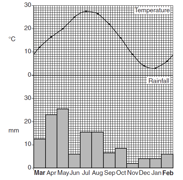
What is the maximum temperature, and in which month does it occur?
27.5 °C,July
40
What is the general direction of the summer monsoon winds from the Arabian Sea?
Southwest to northeast.
40
Name three economic sectors disrupted by heavy rainfall and flooding.
1) Agriculture;
2) Industry;
3) Transport.
50
Which climatic zone has the lowest rainfall, and name two regions within it?
Arid zone: Thar Desert and western Balochistan (Kharan desert)
50
Why do lower latitudes generally experience higher temperatures than higher latitudes? Give two reasons
1) More direct sunrays near the Equator;
2) High angle os sun - solar energy concentrated over a smaller surface area.
50
Q Study Fig., which shows the desert climate of Nok Kundi.
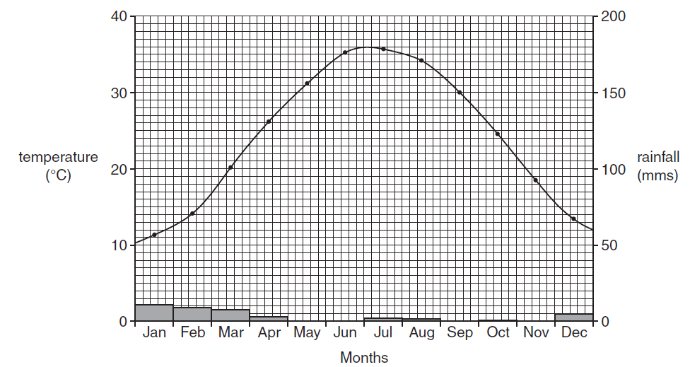
By how much does the temperature rise from January to July?
360C - 110C = 250C
50
Why does northeastern Pakistan receive more monsoon rainfall than southwestern Pakistan? Give two reasons.
North Eastern Pakistan gets rainfall from:
1) Bay of Bengal monsoon;
2) Relief rainfall
3) Convectional/Thunderstorms
50
Name four consequences of prolonged drought for Pakistan's population and economy.
1) Water shortages;
2) Crop failure;
3) Unemployment;
4) Migration.