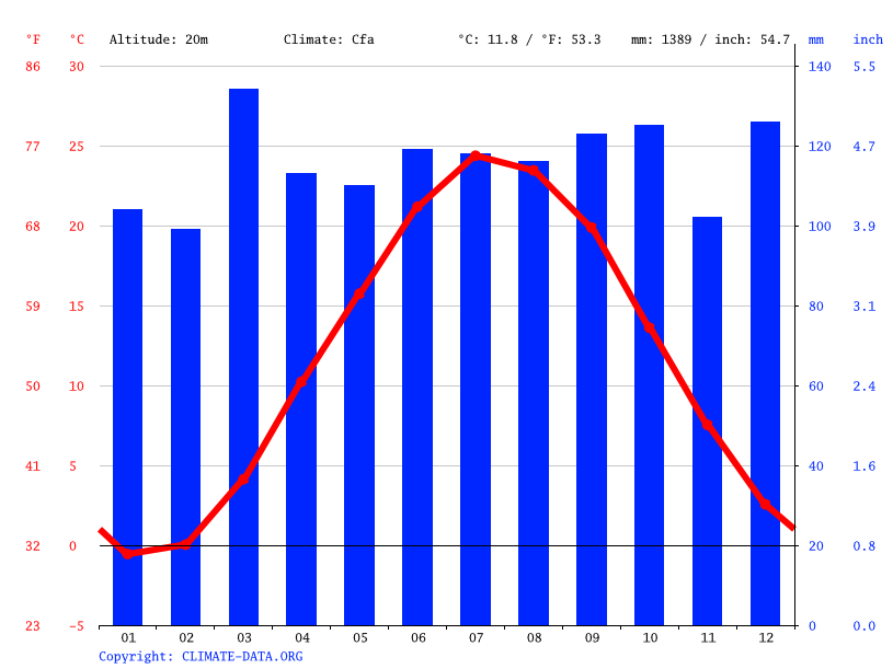
 What do each the bars and lines represent in a climate graph?
Precipitation = bars, lines show temperature
How does the windward side climate compare to the leeward side climate in terms of temperature and humidity.
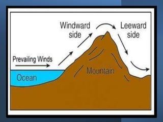
The windward side is cooler and more humid than the leeward side.
Finish the sentence with the following words: rise, sink, low, high
Warm air _______ because it has ______ density, cool air _______ because it has ________ density
Warm air rises because it has low density, cool air sinks because it has high density
Which statement refers to climate and which statement refers to weather?
Statement 1: It rained 40 mm on Sunday.
Statement 2: The average precipitation of July in NY is 10 mm.
Statement 1 = weather
Statement 2 = climate
What is the precipitation and temperature for the month of July? *in mm and Celsius*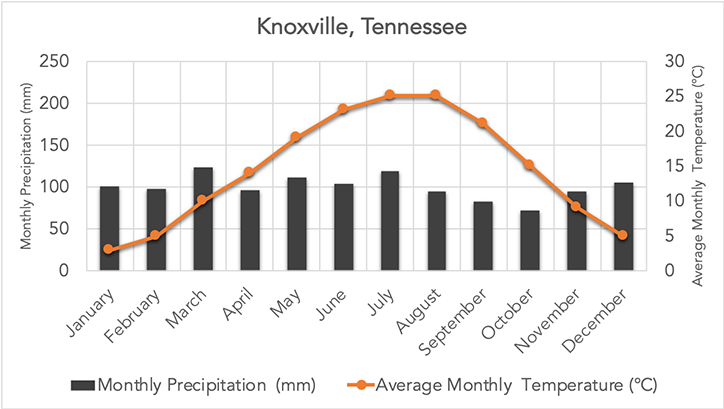
Approximately 26 degrees Celsius temperature, and approximately 125 mm precipitation.
How does the climate of A compare to B in terms of temperature? Make a claim, and provide evidence for this claim.

A is cooler because it is higher up on the mountain/higher altitude.
What is the name of the process where warm air rises and cool air sinks?
Convection
Name the 3 climate zones on Earth.
Temperate, Tropical, Polar
List the temperature and precipitation range of this graph.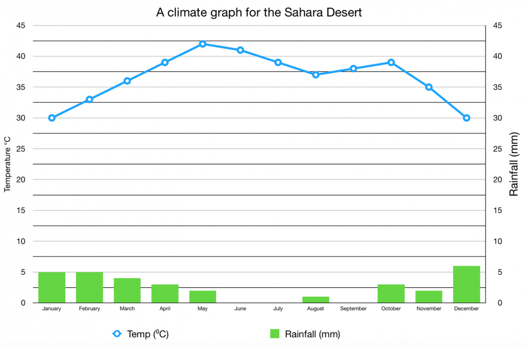
Temperature range is about 13 degrees**, Precipitation range is about 7 mm*
*number should be between 5 and 10.
**temp number should be between 11-14
Make a claim about whether C is cooler or warmer than B. Then, describe the climate factor that causes this difference in average temperature.
C is cooler because it has a higher latitude.
Theoretically, warm water current should move straight up and then cool currents should sink straight down. However, the currents are curved. Explain why the currents do not travel in a straight line.
Coriolis effect - rotation of the Earth
Describe if temperatures are variable or consistent for each of the climate zones. Then, describe how to tell the difference between a temperate and polar climate.
Tropical - consistent
Temperate - variable, lowest temps typically don't go below 26 degrees F.
Polar - variable, lowest temps are usually below 26 degrees F
3 Questions:
1) Is this climate graph variable or consistent?
2) Label the climate zone of this graph.
3) Select which of the following is an appropriate latitude for this graph (10 degrees S, 45 degrees N, 90 degrees S)

1) consistent
2) tropical
3) 10 degrees
Provide a letter for each type of climate zone.
Tropical:
Temperate:
Polar:
And explain how you know that letter belonged to that climate zone
Tropical could be D, C, or B
Temperate could be: E, I, G, H, J
Polar could be: A
How does the climate of east coast of the South American continent compare to the climate of the west coast of the South American continent? Make a claim, and then support that claim with evidence from the diagram.

The east coast is warmer than the west coast. I know this because there are warm currents on the east coast, and cold currents on the west coast.
Compared to D, A will be (humid/dry) and (cool/warm). Make a claim about their difference in climate, and then provide evidence for the claim.
A will be warmer and drier than D since D is on the windward side and A is on the leeward side.
State which climograph is inland, and which is coastal. Provide evidence for your choice.
Then, explain why inland and coastal locations have different climates.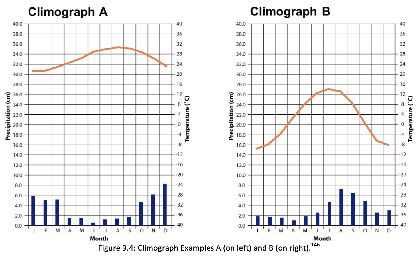
Climograph B is inland, Climograph A is coastal; I know this because A is more consistent/less variable than B. Land/soil heats up and cools down faster than water.
The following image shows Australia. Compare the climate of A and C in terms of temperature ( which is more variable/consistent?), and then provide evidence for your claim.
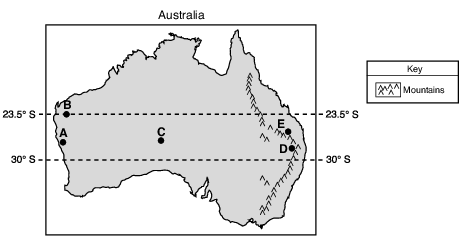
A is coastal so has more consistent temperatures; C is inland and has more variable temperatures. A has warmer winters and cooler summers; C has warm summers and cool winters.
 Where are the majority of warm currents located, and why do most of the warm currents exist in that location?
The majority of warm currents are found near the equator, and most of the currents there are warm because the equator receives the most direct sunlight, which warms up the water.
There are 2 things that cause currents below. One is the Coriolis effect, which causes the curve in winds on this diagram. Explain what the Coriolis effect is. Then, explain what the other reason is for the movement of water and winds in the diagram
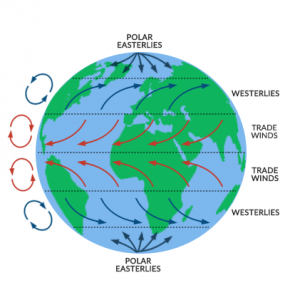
Coriolis effect - rotation of the earth
Other reason: convection/uneven heating of earth's winds and water