Surface Features
Models
Technology
Predicting Impact
100
The picture shows a process of a sand dune being formed.

A student claims that a sand dune is created by both a constructive and destructive force. Which argument BEST explains why the student’s claim is correct or incorrect.
A. The student’s claim is correct; the evidence in the picture shows that sand dunes are formed by the destructive force of wind erosion because the wind is carrying the sand. The evidence in the picture that shows that sand dunes are formed by the constructive force of plate tectonics pushing together when the dune grows taller.
B. The student’s claim is correct; the evidence in the picture shows that sand dunes are formed by the destructive force of wind erosion because the wind is carrying the sand. The evidence in the picture shows that sand dunes are formed by the constructive force of deposition when the sand piles up.
C. The student’s claim is incorrect; the evidence in the picture shows that sand dunes are formed by the destructive force of wind erosion because the wind is breaking apart the land and then carrying it somewhere else.
D. The student’s claim is incorrect; the evidence in the picture shows that sand dunes are formed by the constructive force of plate tectonics because the wind causes the plate tectonics to push together causing the sand dune to grow taller.
What is B?
100
A student is developing an interactive model for her classmates using sand, red clay, and gravel. She places a mound of each type of soil material in the middle of separate large pans so that the height of each mound is 10 centimeters tall. She then measures 50 mL of water into three cups. She creates one “rain cup” that has holes in the bottom and simulates rainfall on each of the mounds using 50 mL of water. Finally, the student measures the resulting height of each mound and records additional observations in a table. Which question is the student most likely trying to answer by demonstrating this interactive model?
A. What soil material absorbs the most rainfall?
B. How does soil deposition affect land after it rains?
C. What soil material erodes the most during rainfall?
D. Why do different materials experience weathering at different rates?
What is C?
100
A farmer notices that water is regularly washing away the topsoil on the steep side of his property after big rainstorms. The farmer wants to learn more about contour plowing to see if this would be a possible solution to the problem. What would be the BEST question that the farmer could ask about contour plowing as a solution to limit the water erosion?
A. Does contour plowing prevent plant growth?
B. Does contour plowing cost a lot of money to implement?
C. Is contour plowing safe for the animals that live nearby?
D. Does contour plowing help to limit water run-off down steep hillsides?
What is D?
100
A family is planning a vacation to Florida in the fall. The family knows that this time of year, Florida experiences hurricanes and tropical storms. What question might the family ask to ensure it will be safe to go on their trip?
A. What do the most recent seismograph reports say about the vacation destination in Florida?
B. What systems are developing in the Gulf of Mexico and Atlantic Ocean according to satellite imagery?
C. How do GIS maps help us understand the land in Florida better?
D. What infrared images are available to help us see when hurricanes happened in previous years?
What is B?
200
The picture shows a volcano erupting.

A student claims that the volcano is showing a constructive force.
Which argument BEST supports the student’s claim?
A. The top of the volcano exploded, causing rocks to break apart.
B. The lava damages the surrounding land so that plants can no longer grow.
c. The flowing lava cools and creates a layer of volcanic rock.
D. The lava pushes the soil down to the base of the volcano causing plants to grow only at the volcano’s base.
What is C?
200
A student has built a model of a hill using sugar cubes as a base and Georgia clay. The student began to pour hot water on the model. Soon, small holes began to appear and the hot water was able to reach the sugar cubes.

The student claims that this model is an example of a force that shapes the surface of the Earth. Which argument makes the best scientific sense?
A. This model represents how caves and sinkholes are formed by destructive forces. The hot water will break apart the sugar cubes allowing for the clay to cave into the empty spaces. The water erosion would cause the cave-ins.
B. This model represents how mountains are created by constructive forces. The water pushes the sediment and rock down to build up the mountain. The sugar and clay represents the mountain and sediments.
C. This model represents how a volcano builds up the earth through constructive forces. The water is the lava that melts through the clay to reach the magma that is the sugar cubes.
D. This model represents how an earthquake can shape the land using constructive forces. The breaking of the sugar is like the movement of the plates that changes the surface of the earth.
What is A?
200
Gotcha!
Lose 200 points!
200
Meteorologists use satellite images to show citizens in a city the weather. Which question could citizens ask to understand why meteorologists use satellite images to help present the weather?
A. How do satellites predict weather to warn people of severe storms or hurricanes?
B. How do satellites keep people at home whenever there is dangerous weather outside?
C. How do satellites communicate the level of intensity that an earthquake will have?
D. How do satellites keep people from getting lost when they use GPS?
What is A?
300
The landform below is a sea arch.
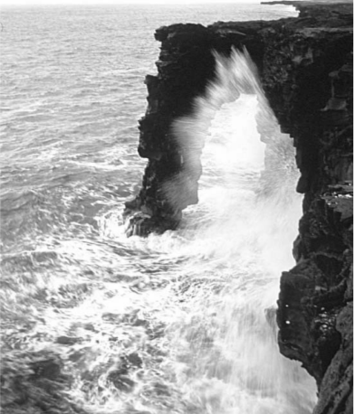
Which of the following statements could be included as evidence to support how a sea arch is formed?
A. Waves are destructive forces that over time can wear away at the earth’s coast and change its shape.
B. Earthquakes are destructive forces that cause breakage of rock formations near the oceans.
C. Waves are constructive forces that deposit sand and sediments on the coast slowly.
D. Earthquakes are constructive forces that build landforms on the coast quickly.
What is A?
300
Two students are performing an experiment to demonstrate how Providence Canyon was formed. Providence Canyon State Park is called the “Little Grand Canyon” of Georgia.

Which of the following is the best model for them to use to explain how the canyon was created?
A. Make a hill out of dirt, sediment and sand in a plastic container, and then pour water over the dirt and sand moving it to a new location.
B. Make a hill out of dirt, sediment and sand in a plastic container, and then tilt the container, moving the dirt and sand to a new location.
C. Make a hill out of dirt, sediment and sand in a plastic container, and then drop rocks on the hill, moving the dirt to a new location.
D. Make a hill out of dirt, sediment and sand in a plastic container, and then use a fan to move the dirt and sand to a new location.
What is A?
300
A well-populated beachfront community in the Outer Banks of North Carolina is trying to decide whether or not to fund the construction of a seawall to protect their homes. To make their decision, they held a community meeting last week. Which of the following questions from the community meeting is most relevant to investigate in order to determine whether or not a seawall is needed?
A. How do the heights of sand dunes compare across the beachfront?
B. How many tourists have visited the beach over the last 5 years?
C. What are the measures of the size of the shoreline over the past 10 years?
D. What is the rainfall total that took place last month with Hurricane Matthew?
What is C?
300
Ouch!
Lose 300 points!
400
The Appalachian Mountains stretch from Mississippi up to Newfoundland, Canada.
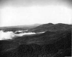
What is the best explanation for how this mountain range formed?
A. Wind has pushed rocks and soil into valleys that have built up over time.
B. Volcanoes erupted for long periods of time and slowly built up the mountains.
C. Rivers and streams flowing down from Canada deposited soil in large amounts until the mountains formed.
D. Part of the Earth’s crust slowly collided until one part was on top of the other and pushed upward.
What is D?
400
OOPS!!
Lose 400 points!
400
A man notices that water is regularly flooding the street near the front of his house. The flooding is also ruining the grass in his front yard. He wants to contact the county to see if they can put in a storm drain on the street outside of his home. What would be the BEST question that the man should ask about storm drains as a solution to limit the flooding?
A. Are storm drains safe for the animals that live nearby?
B. Do storm drains cause flooding to occur somewhere else on the street?
C. Would he have to pay for the storm drain to be put in front of his house?
D. Would a storm drain help to control the road flooding outside of his house?
What is D?
400
There has been frequent seismic activity in California. Which question should scientists ask to help them plan and predict when another earthquake may happen?
A. What has the recent month of satellite imagery over California looked like?
B. Have infrared images picked up the intensity of the vibrations of seismic activity?
C. Has there been a pattern in the seismic activity read from the data on a seismograph?
D. How does GIS maps help California understand how seismic activity relates to the elevation of the land?
What is C?
500
Use the image below to answer the following question.
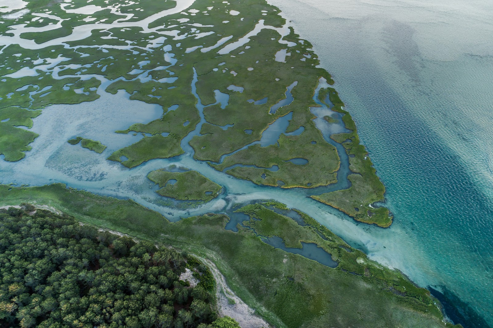
A student claims that the surface feature in the image above was created by constructive processes. Which of the following arguments best supports that claim?
A. The image is of a sea arch, which is created when sediment is deposited at the base of a river until an arch forms.
B. The image is of a river delta, which is created when sediment is deposited at the mouth of the river where it meets a larger body of water.
C. The image is of a river delta which is created when a river carves its way through pre-existing land masses on its way to a larger body of water.
D. The image is of a sea arch, which is created when tides and waves repeatedly weather away at the side of a cliff face until an arch is formed.
What is B?
500
A student developed a model to show the progression of a sea arch and the ocean waves using playdoh. Dates labeled below the image show a timelapse.

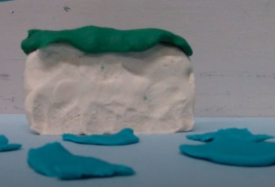
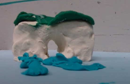
1800 1900 2000
Four of the student’s classmates analyzed the student model on how the model shows constructive and destructive forces. Which of the following students made a correct conclusion based upon the model?
A. Student A: A sea arch is formed by a destructive force. Evidence from the model is that waves carved out the land in a long period of time.
B. Student B: A sea arch is formed by a constructive force. Evidence from the model is that waves build up land in another area in a long period of time.
C. Student C: A sea arch is formed by a destructive force. Evidence from the model is that an earthquake caused the arch to fall down in a short period of time.
D. Student D: A sea arch is formed by a constructive force. Evidence from the model exhibits deposition when the waves build up the land in a short period of time.
What is A?
500
6. The photograph below shows the destruction caused by fast flowing currents in a river near a small town.
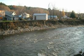
Based on what you can observe in the photograph, which of the following questions would be most helpful in order to decide what they should do to protect the town?
A. How would controlling the flow of a dam help provide water to the citizens in the town?
B. How does the construction of a levee prevent the current of the river from causing erosion on the bank?
C. How does contour plowing help prevent soil loss from water erosion?
D. How would installing storm drains help prevent flooding in the town whenever it rains often?
What is B?
500
A student wants to learn more about seismic activity. Which question should the student investigate to help them understand how seismic activity is measured?
A. How do GIS maps measure the intensity of an earthquake?
B. How do seismographs measure the intensity of an earthquake?
C. How do satellite images show where an earthquake has happened?
D. How do infrared images show where an earthquake has happened?
What is B?