Map types
Symbols
Map lines
Zones
Map Math
100
If you're planning a trip, you might use two different road maps because...
1. some maps are round and some are flat
2. some maps are very inaccurate
3. maps of different scale provide different information about places
3. maps of different scale provide different information about places
100
Which of the following can help you find the distance between two towns on a map?
1. the map scale
2. map colors
3. compass rose
4. the map key
1. the map scale
100
On a map or globe, what is the term for the lines that run from east to west?
1. international date lines
2. parallels
3. meridians
4. corrdinates
2. parallels
100
Where would 10 degrees South latitude be in relationship to the equator?
1. north
2. south
3. east
4. west
2. south
100
If a map's scale shows that one inch on the map equals five miles in real life, how many inches on the map would stand for ten miles?
two inches
200
What is another word for the height of the place?
1. axis
2. coordinates
3. elevation
4. time-zone map
3. elevation
200
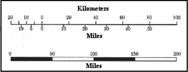
What does the map scale look like?
1. round
2. colorful
3. looks like a ruler
3. looks like a ruler
200
What statement is true?
1. Parallels of latitude sometimes meet.
2. Parallels of latitude are parallel to each other
3. Meridians of longitude never meet.
2. Parallels of latitude are parallel to each other
200
What does the small circle stand for in 90 S?
1. temperate
2. longitudes
3. percent
4. degrees
4. degrees
200
In terms of maps and globes, how many degrees does the sun travel in 1 hour(60 minutes)?
1. 15 degrees
2. 45 degrees
3. 95 degrees
1. 15 degrees
300
What do most physical maps use to show difference in elevation?
1. lines of color
2. scale and coordinates
3. trails or routes
4. a map scale and compass rose
1. lines of color

300
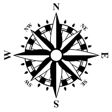
What's the name of the symbol with four arrows pointing in different directions.
compass rose
300
What is the imaginary line that runs around Earth, halfway between the North and South Poles?
1. prime meridian
2. equator
2. equator
300
In general, what happens to the temperature as you move from a lower number of degrees of latitude to a higher number?
1. it gets warmer
2. it gets colder
2. it gets colder
300
If you were in the Central Time Zone and your watch said 1:00p.m., what time would it be in the Eastern Time Zone?
1. 12:00pm
2. 2:00pm
3. 12:00am
4. 2:00am
2. 2:00pm
400
What kind of map would show the natural features of the land?
1. physical map
2. international map
3. colored map
4. time zone map
1. physical map

400
What do map coordinates do?
1. they help you determine the time of day in different locations
2. they let you pinpoint a location
2. they let you pinpoint a location
400
A person might cross the international date line when he or she
1. travels across the United States
2. flies from the Northern Hemisphere to the Southern Hemisphere
3. travels from the Western Hemisphere to the Eastern Hemisphere.
4. moves from one tie zone to another
3. travels from the Western Hemisphere to the Eastern Hemisphere.
400
When you cross this imaginary line on the map, the calendar shifts t a different day. What is this line?
1. the equator
2. the prime meridian
3. the 180 degree meridian
4. the international date line
4. the international date line
400
Match the definition to the vocabulary word.
Where a person or object is facing or moving toward...
1. symbol
2. direction
2. direction
500
If you were reading a road map and wanted to know which roads were interstates highways on the map you would check the...
1. the map key
2. the map scale
3. the compass rose
4. the map coordinates
1. the map key

500
Match the definition to the vocabulary word.
A drawing or picture of a specific place or area of Earth's surface that shows different features.
1. symbol
2. map
2. map
500
Match the definition to the vocabulary word.
How far it is from one point to another.
1. distance
2. map
1. distance
500
How many time zones are in their on earth?
1. 12
2. 24
3. 360
360 degrees = 24 hours (time zones)
500
Match the definition to the vocabulary word.
Electronic equipment that uses radio waves from satellites to give precise information about location and direction.
1. distance
2. Global Positioning System (GPS)
2. Global Positioning System (GPS)