Models
Plates and Vocabulary
Landforms 1
Prediction and Prevention
Landforms 2
100
The image shows two paint trays. The sloping part of each tray is filled with potting soil. Small plants grow in one of the trays.

How can a teacher BEST show how plants affect the erosion of soil?
A. by fertilizing both trays and measuring the mass of the soil
B. by planting seeds in both trays and observing where more of the seeds sprout
C. by adding more soil to each tray and observing how well plants grow
D. by watering each tray and observing how much soil moves to the bottom
D. by watering each tray and observing how much soil moves to the bottom
100
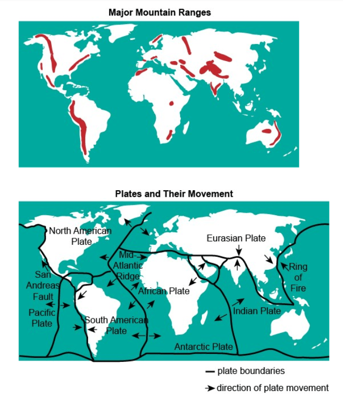
Based on a comparison of the maps, how were the mountains formed between the South American Plate and Pacific Plate, and in between the Eurasian Plate and Indian Plate?
A. The mountains formed between these plates are due to the movement of plates towards each other.
B. The mountains formed between these plates are due to the movement of plates away from each other.
C. The mountains formed between these plates are due to the movement of plates sliding past each other.
D. The mountains formed between these plates are due to both plates moving away and sliding past each other.
A. The mountains formed between these plates are due to the movement of plates towards each other.
100
Are the following changes fast or slow changes?
1. Magma erupts from the surface of a volcano.
2. Cooled lava creates a new landform.
Fast
100
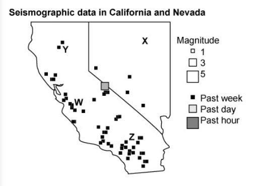
A developer wants to build a new tourist attraction with shops, restaurants, and thrill rides. Which letter is located at the place with the least earthquake activity? A. W
B. X
C. Y
D. Z
B. X
100
Arizona's Grand Canyon was formed by which of the following processes?
A. a series of very minor earthquakes
B. the retreat of multiple glaciers
C. the formation of a single aquifer
D. physical weathering by a large river
D. physical weathering by a large river
200
Camilla finds a rock in her backyard that has a large crack. She creates a model by filling the crack with water and placing it in her freezer. The next day, she removes the frozen rock from the freezer and lets it thaw. She repeats this process twenty times and notices that the crack in the rock has grown deeper and wider. The diagram shows Camilla's model.
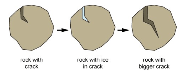
Which process is Camilla most likely trying to model?
A. erosion
B. deposition
C. weathering
D. sedimentation
C. weathering
200
Which of the following is an example of erosion?
A. a river carrying soil downstream
B. the roots of a plant crumbling a cement driveway
C. water freezing in the cracks of a rock and breaking it into many pieces
D. rushing water changing the rough surface of a rock into a smooth surface
A. a river carrying soil downstream
200
DOUBLE JEOPARDY
Earth's surface is always changing. Rock can be broken down into smaller pieces through many different processes. The smaller pieces of rock, called sediment, can be carried away by wind or water. When a river meets a larger body of water, the speed of the water slows down. Sometimes, the slower speed causes some of the sediment to be deposited, forming a delta. The delta forms new channels through which the water flows. A delta is shown.
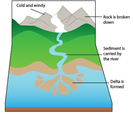 What carries the sediment to a new location?
A. erosion
B. weathering
C. organisms
D. deposition
A. erosion
200

Earthquakes with larger Richter scale values are given a larger square on the map. What is the Richter Scale?
A. It is a way that scientists measure the distance an earthquake travels.
B. It is a way that scientists measure the magnitude of an earthquake.
C. It is a way that scientists measure the depth of the earthquake in the earth's crust.
D. It is a way that scientists measure the amount of rocks moved by an earthquake
B. It is a way that scientists measure the magnitude of an earthquake.
200
An archipelago is a large chain of islands, such as the Hawaiian Islands. These islands were formed by submarine
A. currents.
B. earthquakes.
C. tsunamis.
D. volcanoes.
D. volcanoes.
300
DOUBLE JEOPARDY
What materials could a student model a landslide?
A. paint tray, soil, water.
B. paint tray, concrete, paint
C. rocks, gel
D. nail polish, dirt
A. paint tray, soil, water.
300
The California Institute of Technology has a famous seismological laboratory. Which of the following research projects is most likely to be found in this lab?
A. prediction of hurricane strength
B. studying plants around volcanoes
C. monitoring of fault lines
D. data collection during floods
C. monitoring of fault lines
300
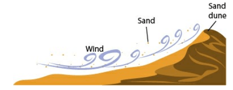
Which BEST compares the formation of the sand dune to the formation of the delta in the passage?
A. The sand dune is also formed through deposition, and the sediment is carried by water.
B. The sand dune is also formed through deposition, but the sediment is carried by wind.
C. The sand dune is also formed through weathering, and the sediment is carried by water.
D. The sand dune is also formed through weathering, but the sediment is carried by wind
The sand dune is also formed through deposition, but the sediment is carried by wind.
300
DOUBLE JEOPARDY
Which tool is BEST able to predict that a volcano will erupt?
A. a seismic wave detector
B. a device that senses air pressure
C. a device that measures carbon dioxide in the air
D. a weather balloon
A. a seismic wave detector
300
Which process is most likely to create new land in a short period of time?
A. glacial movement
B. volcanic eruption
C. thunderstorm
D. earthquake
B. volcanic eruption
400
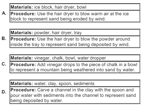
Which instructions would BEST help a student to model the formation of sand dunes?
400

Which two inferences can the students make by using the map?
A. Volcanoes are found only in the ocean areas.
B. Most earthquakes occur in the middle of continents.
C. Earthquakes and volcanoes occur on continents only.
D. Volcanoes and earthquakes are found together in many regions.
E. Volcanoes often occur at the boundaries between continents and oceans.
D. Volcanoes and earthquakes are found together in many regions.
E. Volcanoes often occur at the boundaries between continents and oceans.
400
The picture shows a flowing river.
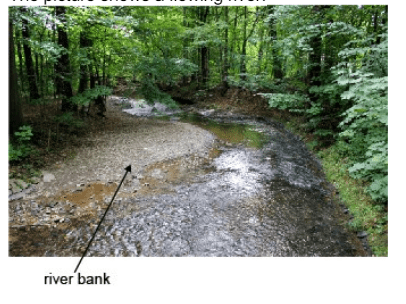
Which statement BEST describes how the collection of rocks and dirt along the river bank formed?
A. The river bank formed through the constructive process of deposition.
B. The river bank formed through the destructive process of compacting.
C. The river bank formed through the constructive process of weathering.
D. The river bank formed through the destructive process of sedimentation.
A The river bank formed through the constructive process of deposition.
400
The table shows the shortest distance, measured yearly, between a fixed pole and the low tide line at a beach.
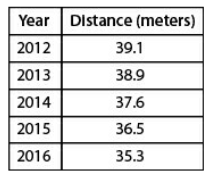
Which is the BEST conclusion one can make from studying the data?
A. The tide line is getting lower.
B. Erosion of the sand is increasing.
C. The beach sand is weathering.
D. Deposition on the beach is decreasing.
B Erosion of the sand is increasing.
400
DOUBLE JEOPARDY
Kenisha has noticed changes in the mountain near her grandmother's house in North Carolina. Some rocks have begun to break off the side of the mountain, changing its face. What is causing this to happen?
A. erosion
B. sandstorms
C. earthquakes
D. weathering
D. weathering
500
The model below shows a river changing over time.
Which of the following best describes the usefulness of this model?
A. to show how acid rain changes the edges of a river bank, changing the path over time
B. to show how erosion and deposition of a river's material change the path of a river over time
C. to show how quickly water evaporates out of a river
D. to show how quickly water travels down a river
B. to show how erosion and deposition of a river's material change the path of a river over time
500
Which of the following is an example of physical weathering?
A. mud sliding down a steep hill
B. wind wearing away a rocky cliff
C. water shifting the position of a sand dune
D. a glacier moving rocks from one place to another
B. wind wearing away a rocky cliff
500
Valley are formed by
A. winds pushing sand and silt onto the floor of the valley.
B. high temperatures drying up a river on the floor of the valley.
C. water levels rising and flooding the floor of the valley.
D. water and ice weathering the floor of the valley.
D water and ice weathering the floor of the valley.
500
DOUBLE JEOPARDY
The picture shows a beach like those on Georgia's coastal islands.
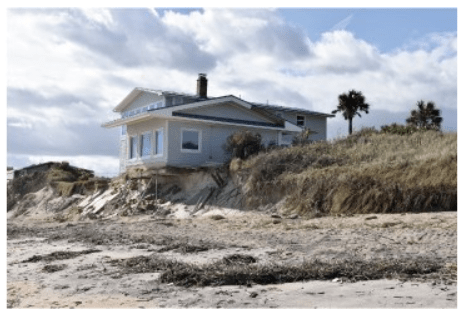
Some of Georgia's beaches have been shrinking. What is causing most of this shrinking?
A. erosion by gravity
B. weathering by wind
C. erosion by ocean waves
D. weathering by organisms
C. erosion by ocean waves
500
The picture shows a beach in southern England.
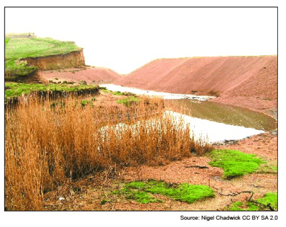
Which feature was caused by sedimentation?
A. cliff face
B. grass
C. dune
D. levee
C. dune