Earth's Layers & Convection
Plate Tectonics & Boundaries
Earth's History & Fossils
Shaping the Landscape
Geologic Evidence & Analysis
100
This is the primary source of heat that drives the convection currents in Earth's mantle.
What is the radioactive decay of elements?
100

Most of the world's active volcanoes are located along these specific geographic features.
What are tectonic plate boundaries?
100
According to the Law of Superposition, the oldest fossils in an undisturbed rock sequence are found here.
What is the bottom layer?
100
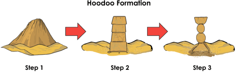
These are the two main geological processes responsible for carving the hoodoos found in Bryce Canyon.
What are weathering and erosion?
100
Rocks with these physical features tend to weather much more quickly than rocks with smooth surfaces.
What are gaps and cracks?
200
In a model of planetary differentiation, the most dense materials (like iron and nickel) would settle in this layer.
What is the core?
200
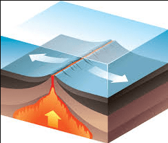
This type of boundary is found at the Mid-Atlantic Ridge, where the seafloor is spreading apart.
What is a divergent boundary?
200
The discovery of coal—made from ancient land plants—in the cold Arctic suggests the area once had this type of climate.
What is a warm (or tropical) forest environment?
200
This natural phenomenon, capable of causing massive coastal damage, can be triggered by undersea earthquakes.
What is a tsunami?
200
This ancient supercontinent is the reason the coastlines of South America and Africa appear to fit together.
What is Pangaea?
300
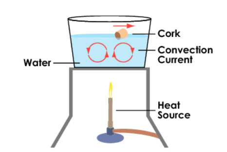
In a classroom model using water, cork, and a burner, the water represents this layer of Earth where convection occurs.
What is the mantle?
300
These two specific landforms are commonly caused by the collision of plates at convergent boundaries.
What are ocean trenches and mountain ranges?
300
Data from Antarctic ice cores show that as atmospheric carbon dioxide (CO2) increases, this also happens to global temperatures.
What is an increase in temperature?
300

Valleys with this specific shape in cross-section are primary evidence of past glacial activity.
What is a U-shape?
300
On a topographic map, these represent features like mountains or canyons and show changes in elevation.
What are contour lines (or landform labels)?
400
This process explains why a young planet separates into layers with different element concentrations as it ages.
What is planetary differentiation?
400
Scientists use this evidence from the ocean floor—which shows normal and reverse patterns—to support the theory of seafloor spreading.
What is magnetic polarity (or magnetic banding)?
400
In a geological column, finding a layer with trilobite and shark fossils below a layer with lizard fossils indicates the environment changed from an ocean to this.
What is a desert?
400
When a river enters a lake and its water velocity decreases, this constructive process forms a new landform.
What is delta formation (or deposition)?
400
This specific geologic event occurs when rock layers are flipped, causing the oldest rocks to appear at the surface.
What is overturning (overturned layers)?
500
While heat makes the core liquid, this factor is responsible for keeping the inner core solid.
What is extreme pressure?
500
Based on the movement of the Pacific Plate over a "hot spot," this is the direction the plate must be moving if the oldest islands are to the Northwest.
What is Northwest?
500
If an igneous dike is found cutting through several sedimentary layers, this is the relative age of the dike compared to the layers.
What is younger?
500
These two glacial features are used to identify the furthest extent of an ice sheet and the direction it moved.
What are terminal moraines and bedrock striations?
500
Scientists determine the exact age of the seafloor by measuring these numbers, which represent time in millions of years.
What are radiometric ages?