Geologic Features
Maps
Rock Layers and Fossil
Weathering, Erosion, and Deposition
Natural Resources
100
The picture shows a map of Italy. Which arrow points to a mountain?
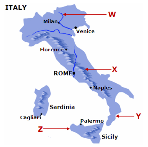
X
100
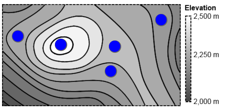
Which blue spot on the topographical map is at the lowest elevation?
100
In the picture, layer W is 100 million years old and layer Z is 500 million years old. How old is layer X?
A. between 100 and 500 million years old
B. There is no way to estimate the age of the layer.
C. under 100 million years old
D. over 500 million years old
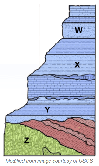
A. between 100 and 500 million years old
100
The cracks in this rock were made by ice. Water went into small cracks and froze. When the ice formed it pushed the rock apart. This happened many times, and each time the cracks got bigger.
What is this an example of?
A. erosion
B. weathering
C. evaporation
D. deposition
B. weathering
100
The graph below shows how much energy is released when different resources are burned. Based on the data in the graph, how do the different resources compare?
A. Oil releases more energy than coal.
B. Wood releases the most energy.
C. Coal releases the least energy.
D. Coal releases more energy than oil.
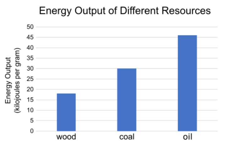
A. Oil releases more energy than coal.
200
Feature U in the picture shows a steep-sided underwater canyon. What is the name of this ocean floor feature?
A. ocean basin
B. trench
C. rift zone
D. continental slope
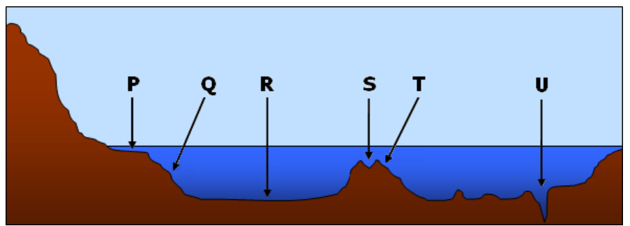
B. trench
200
The map below shows the location of some of the major mountains of the world. Based on the map, what statement is true about the location of the mountains?
A. Mountains generally occur in long chains, or ranges.
B. Mountains only occur in inland regions.
C. Mountains do not occur on large land masses.
D. Mountains do not occur in coastal areas.
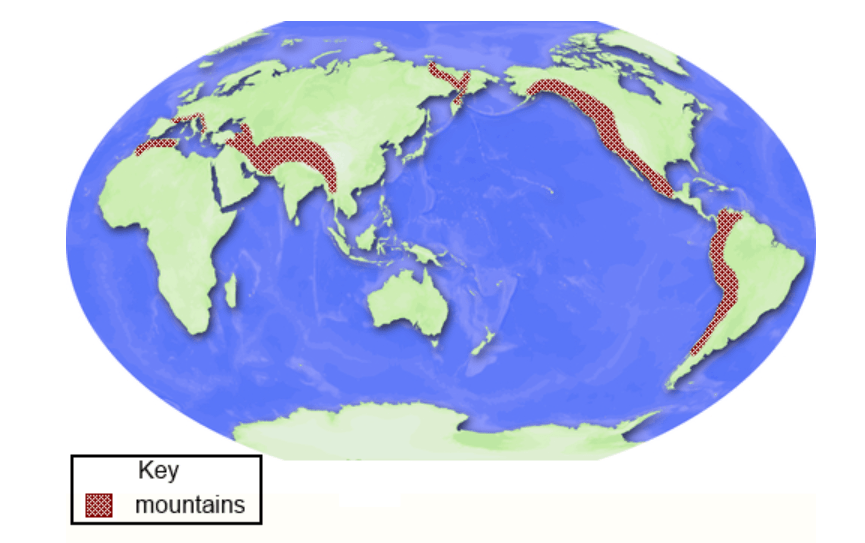
A. Mountains generally occur in long chains, or ranges.
200
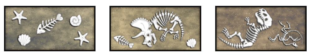
Scientists began to dig in a new location where there are many layers of artifacts and fossils. Today, archaeologists reached the lowest layer and discovered fossils of fish bones and plants there.
What might have been in this area many years ago before all of the other layers of fossils came into being?
A. mountains
B. desert
C. restaurants
D. water
D. water
200
The image below shows a land formation in the southwestern United States. What process most likely caused this land formation?
A. the rock layers moving away from each other over time
B. a moving river forming layers of rock over time
C. a moving river cutting through rock over time
D. the rock layers growing taller over time
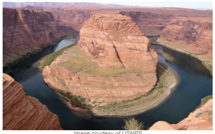
C. a moving river cutting through rock over time
200
What is the main thing people produce from fossil fuels?
A. energy
B. plants
C. fossils
D. water
A. energy
300
Two maps are shown below. The map on the left shows where major earthquakes are most common. The map on the right shows where several active volcanoes are located.
What do these maps show about major earthquakes and volcanic activity?
A. Most earthquakes and volcanic activity happen where the continents meet the oceans.
B. Most earthquakes and volcanic activity happen in the middle of an ocean.
C. Most volcanic activity happens in the middle of the ocean, and most earthquakes happen on the continents.
D. Most earthquakes happen in the middle of the ocean, and most volcanic activity happens on the continents.
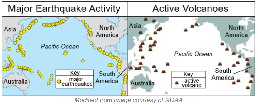
A. Most earthquakes and volcanic activity happen where the continents meet the oceans.
300
The image below shows a map of certain mountain ranges and earthquakes in North and South America. What does the map show about where earthquakes occur?
A. Earthquakes generally occur along the eastern coast of America.
B. Earthquakes generally occur in the central region of America.
C. Earthquakes generally occur around mountain ranges.
D. Earthquakes generally occur only in the ocean.
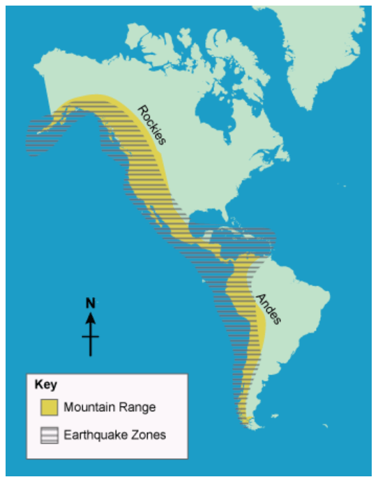
C. Earthquakes generally occur around mountain ranges.
300
A location that was covered in ocean water gradually became dry land over time. Three rock layers from the location are shown below. Put each rock layer in the correct position.
1, 2, 3
300
Many landforms are created through the processes of weathering and erosion. Which statement correctly compares weathering and erosion?
A. Weathering and erosion must always take place at the same time.
B. Weathering and erosion are two names for the same process.
C. Weathering can help erosion happen faster by breaking up rocks.
D. Erosion can make weathering happen slower by breaking up rocks.
C. Weathering can help erosion happen faster by breaking up rocks.
300
Since the mid-1800s, humans have been generating more and more energy by burning fossil fuels.
Which of the following are benefits of burning fossil fuels for energy? (choose more than one)
A. Transportation with cars, ships, and airplanes is cheap and widespread.
B. Burning fossil fuels releases large amounts of pollution into the atmosphere.
C. Fossil fuels are a renewable resource, so they will never run out.
D. Currently, energy can be generated from fossil fuels at a lower price than from other methods.
A. Transportation with cars, ships, and airplanes is cheap and widespread.
D. Currently, energy can be generated from fossil fuels at a lower price than from other methods.
400
This true-color image shows the entire Earth. Examine the oceans. Which of the following best describes the Earth's oceans?
A. large bodies of water separated by land
B. one body of water completely surrounded by land
C. one body of water surrounding the land
D. large bodies of water surrounded by land
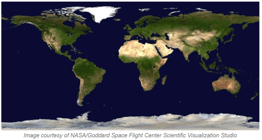
C. one body of water surrounding the land
400
A satellite image and a topographic map of the island of Hawaii are shown below.
A farmer wants to buy a large, flat piece of land on the island to plant crops. What location best fits this description?
A. Z
B. W
C. Y
D. X
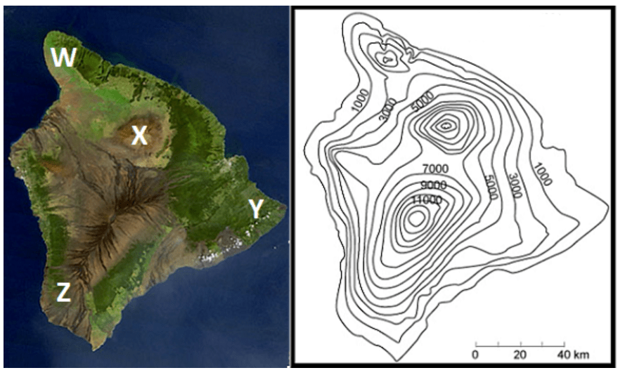
C. Y
400
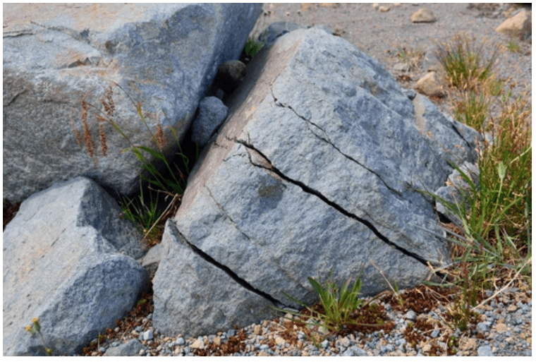
The picture below shows a large rock formation. The arrow points to a part of the formation that has changed. What is the best explanation of these changes?
A. Soil erosion caused a crack in the rock formation.
B. The rock formation broke and was not able to move.
C. Animals digging caused a crack in the rock formation.
D. The rock formation broke and moved over time.
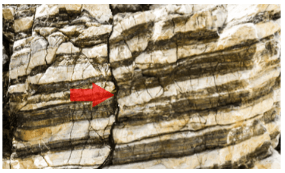
D. The rock formation broke and moved over time.
400
At the beach, Omar watches sand blown by the wind. The sand does not pile up as much in flat, open places as it does near small hills. The sand piles slowly grow taller as wind keeps dropping sand onto them. Later, Omar visits large sand dunes at that beach. They are shaped like the small piles of sand he saw earlier.
What best describes how the large sand dunes formed?
A. They formed over long periods of time as wind slowly deposited sand near hills.
B. They formed over long periods of time as wind carried huge boulders from far away.
C. They formed over short periods of time as wind sucked sand up from deep in the ground.
D. They formed over short periods of time as wind broke down a mountain in that same spot.
A. They formed over long periods of time as wind slowly deposited sand near hills.
400
Each table describes a different energy resource. Determine the name of the resource that best fits the description in each table.
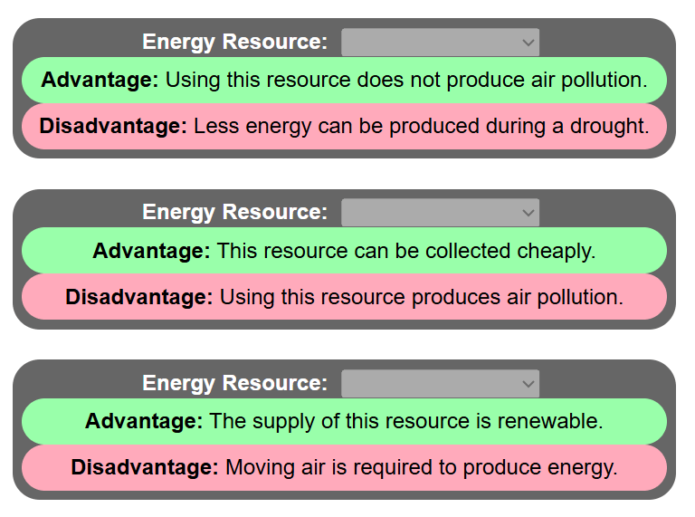
1. Hydropower
2. Coal
3. Wind Energy
500
Brandie is touching the Atlantic Ocean on a globe with her finger. She decides to trace along the globe without lifting her finger. She wants to know how many oceans she can touch without having to cross land with her finger in order to get to them. What will happen when she tries?
A. She will be able to trace her finger across all the oceans without having to touch any land.
B. She will be able to touch every ocean except one without touching land.
C. She will not be able to reach any ocean except the Atlantic without first touching land.
D. She will be able to trace her finger across half the globe before she has to touch land.
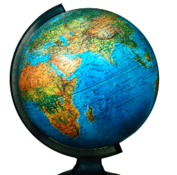
A. She will be able to trace her finger across all the oceans without having to touch any land.
500
Carlee is using the map below to plan a camping trip. Carlee wants to set up her tent on flat land. Which point on the map shows the flattest land?
A. point Y
B. point Z
C. point W
D. point X
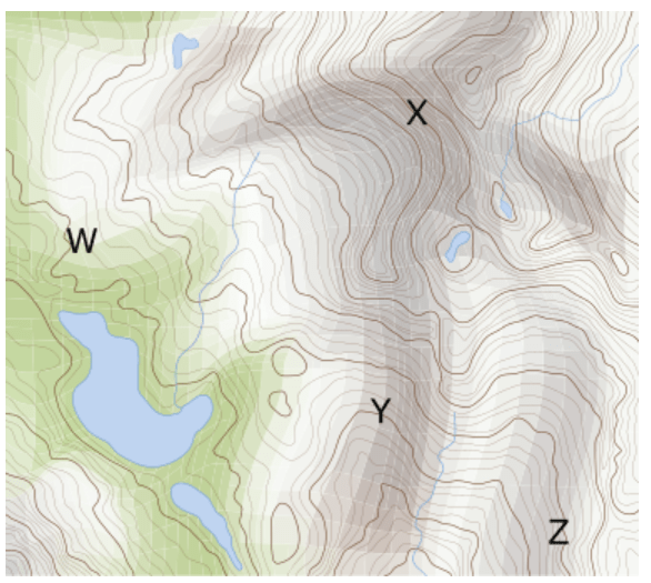
C. point W
500
Fossils found in upper layers of sedimentary rock are _________ than fossils found in lower layers of sedimentary rock.
Younger/Newer
500
At the place where a river meets an ocean, there is a large deposit of river sediments. This deposit area is called the river delta.
What process happens farther up the river to bring the sediments to the delta?
A. volcanic eruptions
B. earthquakes
C. erosion
D. friction
C. erosion
500
Each table describes a different energy resource. Determine the name of the resource that best fits the description in each table.
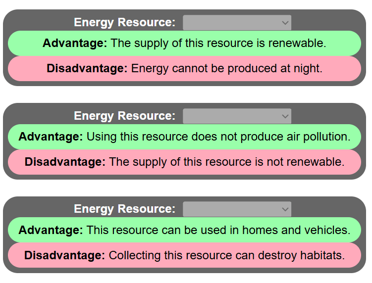
1. Solar Energy
2. Nuclear Energy
3. Oil/Natural Gas