Category 1: 💧 Water Changes the Land
Category 2: 🏜️ Canyon or Delta?
Category 3: 🍑 Georgia Canyons
Category 4: 📊 Scientists Use Data
Category 5: 🔬 Model It!
100
A student drips water repeatedly onto the same spot in a pan of moist soil. After several drops, a small hole forms.
Question: What destructive process is the water modeling?
Answer: Weathering and erosion by water.
100
Moving water repeatedly wears away rock and sediment, eventually creating a deep gorge with steep sides.
Question: What surface feature formed?
Answer: A canyon.
100
A Georgia canyon formed when rainwater eroded former farm fields.
Question: Which canyon is being described?
Answer: Providence Canyon.
100
A student writes:
“The soil felt wet, and a deep channel formed.”
Question: Is this qualitative or quantitative data?
Answer: Qualitative data because it describes what was observed.
100
A class creates an interactive, three-dimensional representation of a landslide using a baking pan, soil, rocks, trees, and houses.
Question: What type of model did they create?
Answer: A physical model.
200
A student continues adding water to a small hole in a pan of soil. The hole becomes deeper and wider.
Question: What does this observation demonstrate about moving water?
Answer: Moving water can weather and erode sediments, changing Earth’s surface.
200
A river carries weathered and eroded sediment toward a larger body of water. The sediment is deposited at the river's mouth and begins building new land.
Question: What surface feature is forming?
Answer: A delta.
200
Scientists investigate a Georgia canyon that took millions of years to form as moving water from Bear Creek and Daniels Creek weathered and eroded sedimentary rock.
Question: Which canyon are they studying?
Answer: Cloudland Canyon.
200
Another student records:
“The channel measured 2 centimeters deep.”
Question: Is this qualitative or quantitative data?
Answer: Quantitative data because it uses a numerical measurement.
200
After completing the landslide experiment, students draw pictures showing the hillside before and after the simulated rainstorm.
Question: What type of model did they create?
Answer: A visual model.
300
A student first uses a dropper to add small amounts of water to soil. Later, the student pours a much larger amount of water onto the same soil. A channel forms.
Question: Why did the larger amount of water cause a greater change?
Answer: Greater amounts of water can cause greater changes to Earth’s surface.
300
Scientists investigate a landform and discover that it formed when sediment was removed by moving water.
Question: Is the formation of this feature most likely constructive or destructive?
Answer: Destructive, like the formation of a canyon.
300
A student says:
“Providence Canyon and Cloudland Canyon formed in exactly the same way and took about the same amount of time.”
Question: What evidence from Chapter 2 proves this statement incorrect?
Answer: Providence Canyon formed relatively quickly from rainwater erosion, while Cloudland Canyon formed very slowly over millions of years from moving creek water, weathering, and erosion.
300
A student measures a hole before and after adding more water. Question: What conclusion is best supported by the data? 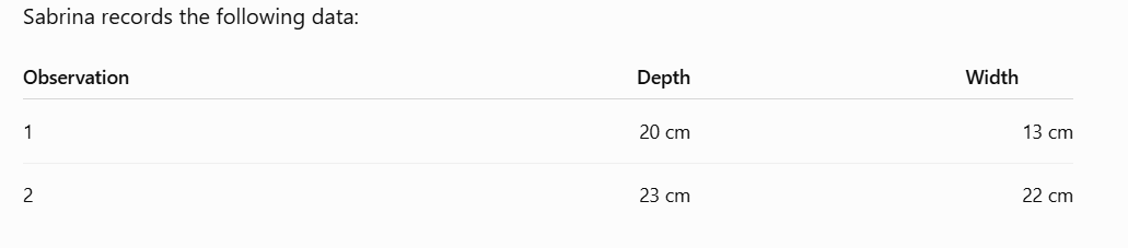
Answer: Adding more water caused greater erosion because the hole became deeper and wider.
300
Scientists cannot bring an actual canyon or landslide into a classroom, so students use pans, soil, water, and other materials.
Question: What is one major benefit of using these models?
Answer: Models allow students and scientists to study large-scale Earth processes on a smaller scale.
400
During an investigation, water carries sediment away from its original location and leaves a deep channel behind.
Question: Which landform is this model most likely representing?
Answer: A canyon.
400
A river erodes sediment from one location and later deposits the sediment where the river enters a larger body of water.
Explain why the same river can cause both destructive and constructive changes.
Answer: Erosion is destructive because the river removes sediment, while deposition is constructive because the river deposits sediment and builds new land.
400
In the early 1800s, farmers cleared land to grow cotton. The soil began eroding. Small gullies became deep trenches, and eventually canyons developed.
Question: Which combination best explains the formation of these canyons?
A. Wind and deposition
B. Rain and erosion
C. Ice and deposition
D. Lava and weathering
Answer: B. Rain and erosion
400
Students model a landslide. Before adding water, sediment at both the top and bottom of the model measures 7 cm deep. After the simulated rainstorm, sediment at the top measures 2 cm, while sediment at the bottom measures 12 cm.
Question: What happened to the sediment?
Answer: Sediment eroded from the top of the hill and was deposited at the bottom.
400
Students want to collect quantitative data from their landslide model.
Which tool would be most useful?
A. Ruler
B. Camera
C. Drawing
D. Notebook
Answer: A. Ruler
500
Water removes sediment from one part of a model and carries it to another location, where the sediment settles.
Question: Identify the destructive and constructive processes occurring.
Answer: Erosion is destructive because sediment is carried away. Deposition is constructive because sediment is deposited in a new location.
500
Two students disagree.
- Student A says, “Canyons and deltas have nothing in common because one is destructive and the other is constructive.”
- Student B says, “They are different, but both can involve rivers and eroded sediment.”
Question: Which student has the better argument? Explain.
Answer: Student B. Canyons can form when rivers weather and erode sediment, while deltas form when rivers deposit weathered and eroded sediment.
500
Two photographs show different Georgia canyons. Canyon A formed in only a few hundred years. Canyon B took millions of years to form.
Question: Identify Canyon A and Canyon B and explain one similarity.
Answer: Canyon A is Providence Canyon. Canyon B is Cloudland Canyon. Both formed through water erosion.
500
A student claims that a landslide is only destructive.
The class records:
Before:
Top = 7 cm
Bottom = 7 cm
After:
Top = 2 cm
Bottom = 12 cm
Use the data to explain why the student's claim is incorrect.
Answer: The landslide was destructive because sediment was eroded from the top, decreasing from 7 cm to 2 cm. It was also constructive because sediment was deposited at the bottom, increasing from 7 cm to 12 cm.
500
Students build a model of a hillside. Heavy simulated rain causes rocks, sediment, trees, and model houses to move downhill. Some material remains at the top while other material collects at the bottom.
Question: Put these events in the correct order:
- Gravity pulls eroded materials downhill.
- Rain erodes sediments and rocks.
- Materials are deposited at the bottom.
- Large amounts of rain fall.
- Materials are originally located on the hillside.
Answer:
1. Materials are located on the hillside.
2. Large amounts of rain fall.
3. Rain erodes sediments and rocks.
4. Gravity pulls the eroded materials downhill.
5. Materials are deposited at the bottom.