People
Tools of the Trade
Weekly Subjects
Maps Volume 1
Maps Volume 2
100
This cartographer adopted James Gall's world map projection as a less Eurocentric and supposedly more accurate alternative to Mercator's projection
Who is Arno Peters
100
This map projection dates from 1569, but has been challenged and sometimes replaced by the Peters Projection in the 20th and 21st century for its Eurocentrism
What is the Mercator Projection
100
This is the practice of indigenous peoples asserting their land rights through cartography
What is counter-mapping
100
This indigenous artifact might be a map depicting a king and the communities under his rule 
What is Powhatan's Mantle, c. 1600
100
This map represents the English perspective on the New World, with information gathered from Indian informants
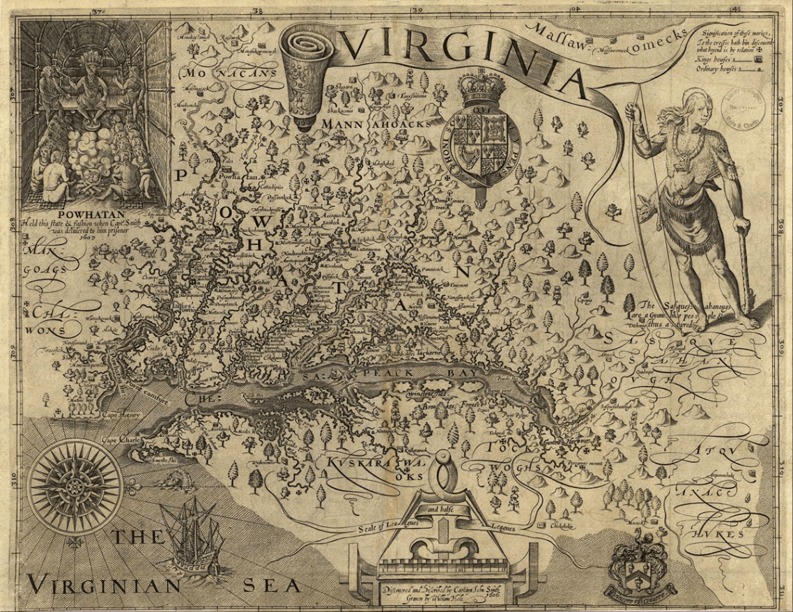
What is Virginia, John Smith 1624
200
This British surveyor and explorer began his career mapping Canadian territories in the Seven Years War, and made his most famous surveying voyage to Australia
Who is James Cook
200
This mapping technology was developed in the 1950s using satellites to survey the earth
What is GPS (Global Positioning System)
200
These shells were used by indigenous peoples in North America to make belts that were traded as a sign of peace. The designs mapped the tribe's history and human geography
What is wampum
200
This indigenous map is a sociogram that an indigenous tribe used to assert its centrality to colonial trade 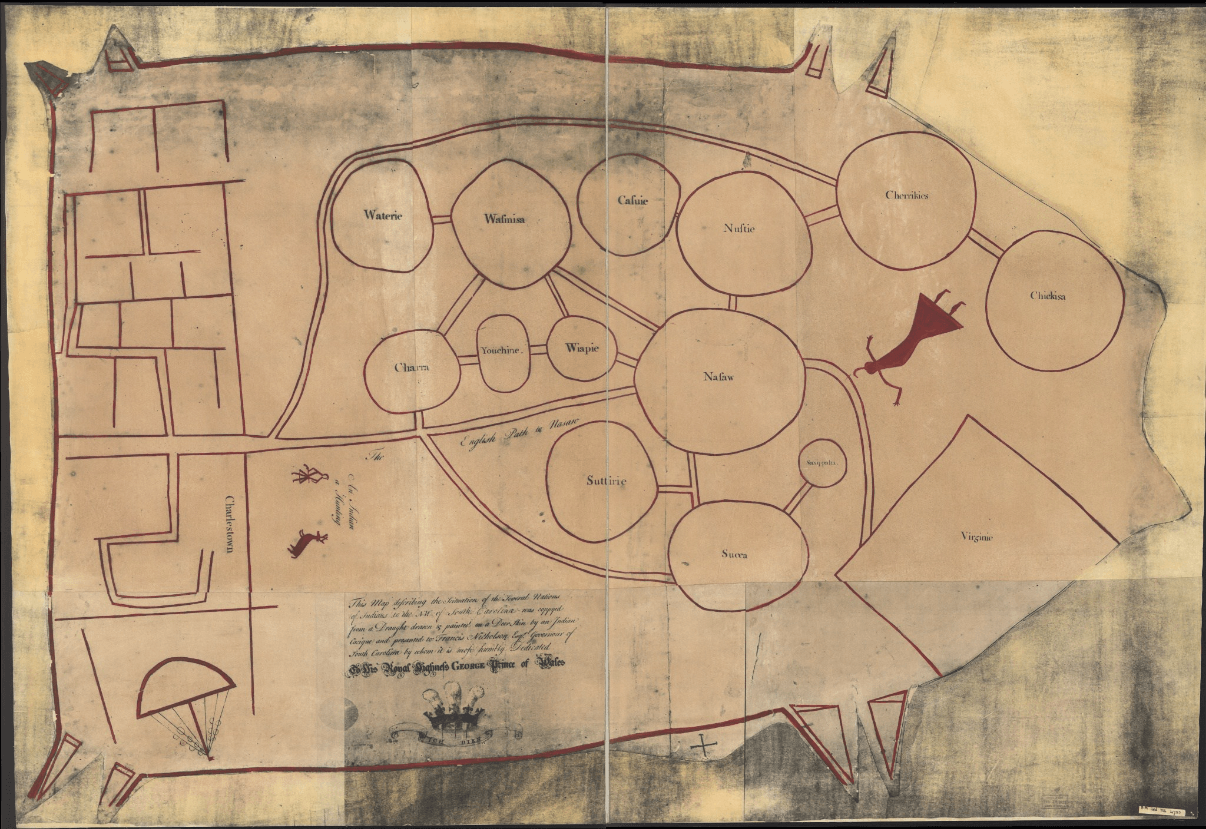
What is the Catawba Deerskin Map, c. 1724
200
This map notably presents Australia as a prehistoric land of exotic animals without a human history 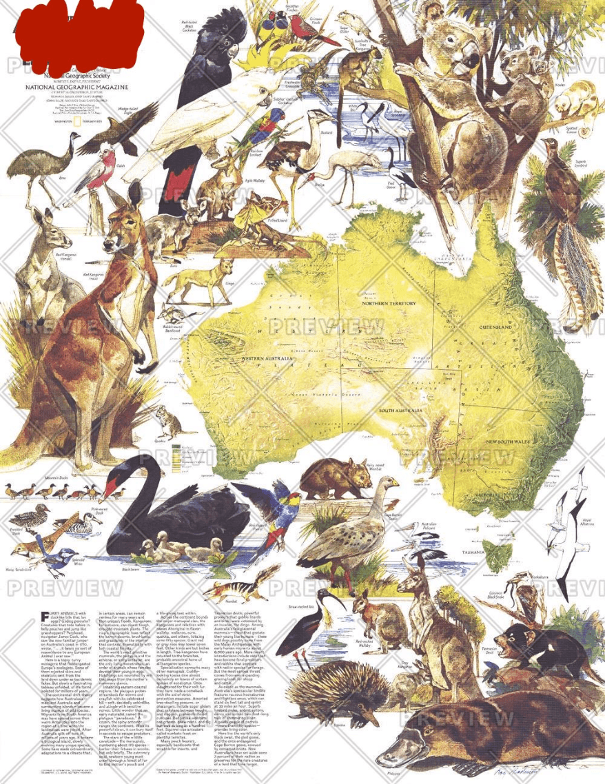
What is National Geographic, Land of the Living Fossils, 1979
300
This cartographer descended from an influential family of mapmakers and saw his life's work of the Carte de France confiscated in the French Revolution
Who is César-François Cassini, or Cassini III
300
This mapping technology was developed to serve environmental branches of government to capture, store, manipulate, analyze, manage, and present spatial and geographic data.
What is GIS (Geographic Information System)
300
This federal program makes the official charts for the United States as part of the National Oceanic and Atmospheric Administration (NOAA). It is responsible for mapping 3.4 million miles of the US coastline.
What is the US Coastal Survey
300
This map was the first of its kind and set the standard for similar maps to prioritize information over geography

What is Henry Beck's map of the London Underground, 1931
300
This early modern map depicts a city experiencing rapid, massive population growth and depict the entire city in a detailed panorama

What is Civitas Londinum, or the Agas Map of London, c. 1541-1621
400
Commissioned by Lord Halifax to make a map that supported British claims to America, this mapmaker had little cartographic experience and created the map based on surveys sent from America to London
Who is John Mitchell
400
This type of indigenous map depicts the geography of both a physical and social space, often using circles and lines. The Catawba Deerskin Map is an example
What is a sociogram
400
Created by the English Council for Trade and Plantations, this atlas emphasizes the importance of sugar-producing islands and represents the British government's increased involvement in colonization
What is the Blathwayt Atlas
400
This map can be used to draw conclusions about concentrations of influence in the cartographer's neighborhood

What is Jack O' Lanterns, Denis Wood, 2010
400
This map of slums in Algiers was part of a presentation made by architects hoping to redesign the city's shantytowns 
What is the map of bidonvilles in Algiers, CIAM-Alger presentation panel, 1953.
500
This cartographic artist created a series of maps of his neighborhood - including maps of jack-o-lanterns, wind chimes, and leaf patterns - in order to map the experience of living there.
Who is Denis Wood
500
This type of survey combines empirical geographic evidence with mathematical calculations of longitude to produce highly accurate maps. The Cassini family of France produced the Carte de France using this technique
What is a geodetic survey
500
From Sheila Crane's lecture, these slums were located in French Algeria in the mid-twentieth century. French architects created a project to redesign them.
What is a bidonville
500
This map was created by a settler of the failed Roanoke colony and depicts America from the perspective of early settlers, with multiple Indian settlements and west oriented at the top
What is John White, Americae Pars, Nunc Virginia Dicta, 1590
500
This nautical chart is an example of the work done by
the federal agency responsible for charting the American Coastline
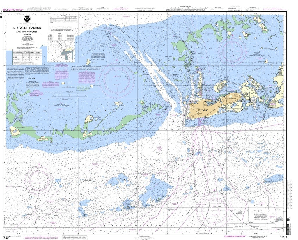
What is U.S. Coast Survey, NOAA, Key West Harbor and Approaches, 2013