Imaginary Lines
Water and Hills
Mix it All Up!
Which Way?
The Originals
100
The imaginary line that divides the earth into northern and southern hemispheres is called
What is the Equator?
100
This river borders the state of Texas and flows into Mexico?
What is the Rio Grande River?
100
Which Native American region is NOT located in the United States?
What is the Arctic Region?
100
This symbol on a map shows directions.
What is a compass rose?
100
These Native Americans lived in very hot and dry land and didn't get a lot of rain.
What are the Southwest Native Americans?
200
The imaginary lines that run east and west are called
What are lines of latitude?
200
This mountain range is found in the eastern part of the United States.
What are the Appalachian Mountains?
200
What type of line is the Prime Meridian?
What is a line of longitude?
200
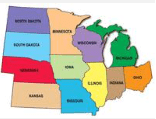 According to the map, Michigan is _______ of Wisconsin.
What is East?
200
This region had lots of salmon and trout. They also lived in a region where they used the cedar trees to make their houses, totem poles, canoes, etc.
What is the Pacific Northwest Region?
300
The imaginary line that runs north and south and divides the earth into eastern and western hemispheres is called
What is the Prime Meridian?
300
This river was named after a European explorer and is located in New York.
What is the Hudson River?
300
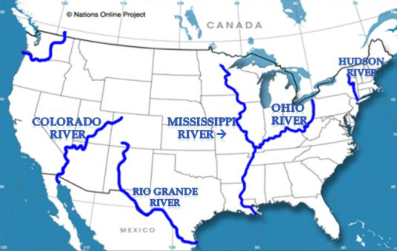
Which river is closest to the Atlantic Ocean?
What is the Hudson River?
300
What are the two types of directions shown on a compass rose?
What are cardinal and intermediate directions?
300
The state of Georgia is located in which Native American Region?
What is the Southeast Native American Region?
400
Imaginary lines that run north and south are called
What are lines of longitude?
400
This river starts in Minnesota and flows into the Gulf of Mexico.
What is the Mississippi River?
400
This map feature can help you tell the distance between two locations
What is a map scale?
400
This feature on a map shows symbols and where things are located
What is a map key/map legend?
400
The Native Americans in this region lived in longhouses and planted corn, squash, and beans which they nicknamed the "Three Sisters."
What are the Northeast Native Americans?
500
33 degrees north latitude and 84 degrees west longitude are called what on a map
33° N, 84° W
What are coordinates?
500
The Southwest Native Americans made their homes in these mountains
What are the Rocky Mountains?
500
The United States is bordered by two countries. Which country is at the northern border? Which country is at the southern border?
What are Canada and Mexico?
500
This type of map shows land forms and bodies of water.
What is a physical map?
500
These Native Americans lived on flat, grassy land and migrated to follow the herds of buffalo.
What are the Plains Native Americans?