Random
Unit Guide
Map Skills
Vocabulary
100
Weather over a long period of time is called?
Climate
100
Which Hemisphere is the country of Canada located in?
North West Hemisphere
100
Name the 5 parts of a map
Title, Compass Rose, Legend, Scale, Grid
100
All plants and trees in a particular area.
Vegetation
200
A map that outlines the boundaries of states and countries
Political Map
200
The most important Latitudinal line is the ____________ where all other lines are referenced from, but the most important Longitudinal line is the _______________ where all other longitudinal lines are referenced from.
equator, prime meridian
200
What ocean is figure A in?
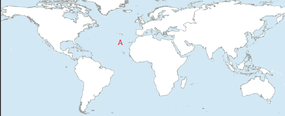
Atlantic Ocean
200
Method used to represent the Earth's surface on a flat map.
Map distortion
300
A map that shows the mountains, rivers, lakes and other features
physical map
300
The most accurate way to represent the earth is a __________, because you can get exact rations and no distortion of land or water.
Globe
300
What are the coordinates for A?
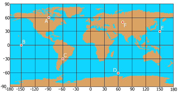
60N, 90W
300
In the city of Chicago, the ____________ is so high that you can practically feel the constant energy of people all around you.
Population Density
400
What are the coordinates for F?
around (50N, 70E)
400
What is the name of Coach V's Wife?
Hannah
400
If it is summer in Alabama, what season is it in Sydney Australia?
Winter
400
When studying geography, a ____________showcases the natural features like mountains and rivers, a _______outlines the boundaries and divisions of countries, and a _________ highlights population density, giving a comprehensive view of various aspects of a region.
Physical Map, Political Map, Thematic Map
500
The three different climate zones are what?
Tropical, temperate, and polar
500
The study of ____________ focuses on natural features like mountains, rivers, and climates, while _____________ examines the interaction between people and their environments, including topics like population distribution, urbanization, and cultural landscapes
physical geography, human geography
500
What is more important in determining a places vegetation and climate, latitude or longitude? Explain why?
Latitude. There can be multiple climate zones in a single longitudinal plane, but only one climate zone in a latitudinal line
500
Amidst the sprawling suburbs, the ________is pinpointed by GPS coordinates, whereas the ____________ is characterized by its position in relation to the nearby shopping mall and school.
Absolute Location, Relative Location