Unit 1
Unit 2
Unit 3
Mysteries
More Mysteries
I'm a Mysterious Guy
100
Explain what geography is.
A science that deals with the description, distribution, & interaction of the diverse physical, biological, & cultural features of the Earth's surface
100
Explain what industrialization is.
The transition from an agrarian society to one based on factories & manufacturing.
100
Explain the difference between push & pull factors.
1) Push factors = factors urging someone to leave a location
2) Pull factors = factors urging someone to come to a new location
100
Explain why humans created the system of longitude & latitude.
Humans created latitude and longitude as a universal coordinate grid to accurately locate places, navigate distances, and map Earth consistently.
100
Explain the main quality of both a political & physical map.
1) Political = shows boundaries between countries
2) Physical = shows physical land characteristics like mountains
200
Explain the difference between regions and continents
Continents are larger & broader. Regions are smaller & more specific.
200
What is the general conclusion that can be drawn from this graph?

More developed countries are generally more urbanized than less developed countries.
200
When children contribute to the economic survival of the family, this generally leads to a ______ ______ rate.
A high birth rate.
200
Explain the difference between modifying an environment versus adapting to an environment.
Modifying changes the environment to meet human needs, while adapting adjusts human behavior or habits to existing environmental conditions.
200
Which tool of a geographer is pictured below?

Cartogram
300
Explain the difference between political and physical maps.
A physical map shows features such as mountains and landforms. A political map shows boundaries between countries.
300
Explain the difference between commercial land use & mixed-use development.
1) Commercial land use = Area used for private businesses
2) Mixed-use development = Combines land-use types, such as residential & commercial
300
Identify which pyramid indicates a more and a less developed country.

A = less developed
B = more developed
300
Explain what climate graphs display & what they help us understand.
Climate graphs display monthly temperature and precipitation patterns, helping us understand local climate trends, seasonal changes, and environmental conditions over time.
300
During which time period did the world population begin to dramatically increase?

1800-1900
400
Explain the difference between absolute and relative location.
Absolute location is the precise geographical coordinates of a point on the Earth's surface. Relative location is the position of a place in relation to other landmarks.
400
Explain what the Central Business District (CBD) is & identify which letter indicates the CBD of Austin.

The urban core with concentrated commercial, financial, & civic activities.
400
What is the formula for finding the natural rate of increase? (also called the natural growth rate)
Birth rate minus death rate = natural rate of increase
400
Explain what a biome is.
A biome is a large ecological region defined by climate, vegetation, and wildlife adapted to shared environmental conditions.
400
Explain the difference between weather & climate.
1) Weather = day-to-day conditions
2) Climate = long term conditions
500
Explain the difference between latitude and longitude.
Latitude; 0° = Equator & lines are parallel to equator
Longitude lines run north & south; prime meridian is at 0°
Created to provide a consistent, global grid system for locating places on Earth
500
What are the 2 least urbanized continents according to this graph?
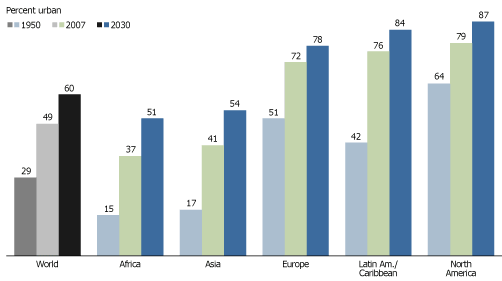
Africa & Asia
500
What has been the primary push factor for this increased Latin American migration to the U.S.?
To find new economic opportunities such as jobs.
500
Explain what happens as elevation increases.
The air gets thinner and the temperature gets colder.
500
What does a country’s rate of natural increase indicate?
How fast its population is growing each year
600
Explain the main reasons why storms form.
Storms form when atmospheric instability, moisture, and rising warm air interact, creating pressure differences that generate clouds, wind, and precipitation.
600
Explain what gentrification and its general effect.
It is the buying up and renovation of deteriorated urban houses and stores, which causes surround property prices to increase.
600
Which 2 stages have the highest natural rate of increase? (the rate of the population growth)

Stages 2 & 3
600
What is the most commonly used type of map projection? (Hint: __________ projection)
Compromise projection
600
What concept explains why is there so little difference between summer & winter along the coast of California? (Hint: starts with the letter "c")
Continentality
Close to a large body of water = smaller differences in temperature
Further away from water = greater difference in temperatures