What are the two primary subfields of the discipline of geography?
Human and physical geography
When deciding whether to grab an umbrella on your way out of the door, are you thinking about your location's weather or it's climate?
Weather
What are the two types of data shown on a climograph?
Precipitation and temperature
Which climate type is specific to areas where their climate is most controlled by high elevation?
H - highlands climates
Who / what do the majority of scientists believe has lead to climate change?
Greenhouse gas emissions from humans
What discipline of geography studies the interactions between the human and physical world?
Environmental geography
If you planning to move to a new location, would you have a better understanding of what to expect in that location by looking at a 10-day weather forecast or the location's climatic normals?
Climatic normals
How are temperature and precipitation averages visually represented on a climograph?
Temperature averages are shown by a line (one dot on the line for each month).
Precipitation averages are shown by bars (one bar for each month).
What climate type is the driest? How dry does areas with this climate type need to be?
B - dry climates
The amount of precipitation must be less than the amount of potential evapotranspiration.
What is the greenhouse effect?
Greenhouse gasses act as insulation around the blanket. As more greenhouse gasses enter the atmosphere, less solar radiation escapes back out to space causing the Earth to warm.
What are the two different rationales for why geography matters?
Local: geography matters so you can understand where you are
Global: geography matters so you can understand conditions in other places and our connections with those places
How many years worth of data is averaged to create a climatic normal?
30 years worth of data is averaged.
This averaging takes place every 10 years.

Which of these locations is on the windward side of the mountains? Which of these locations is on the leeward side of the mountains? Explain your reasoning.
Yakima, WA must be on the leeward side of the mountain because it has way less precipitation than Packwood, WA. The windward side of mountains have more precipitation because when moist air rises up the mountain, it cools and clouds can form and precipitation can occur.
Baldwin, Wisconsin
D - cold mid-latitude climate
How are renewable energy resources different than non-renewable energy resources?
Renewable energy resources replenish themselves naturally and indefinitely.
Non-renewable energy resources do not replenish themselves naturally (or if they do, they do so extremely slowly, like fossil fuels which take 10s of millions of years to form)
What is spatial correlation?
Two different things occuring in similar places
In the modern era of climate change, why do some scientists disagree with the use of 30 years of data for a climatic normal? What do they propose instead?
They argue that the climate is changing so rapidly that data from 30-40 years ago can't be labelled as "normal" about what to expect today.
They propose using only 15 years of data and averaging them every 5 years.

What season is precipitation most likely in this area? Is this location close to a coast or far inland? Explain your reasoning.
Precipitation is most likely in the summer months. The precipitation bars are largest in the months with the warmer temperatures.
There is quite extreme seasonal temperature variation between the coldest month, January, and the warmest month, July, so this location is likely far inland.
Marathon, Florida
A - Tropical climate
What are two greenhouse gasses besides carbon dioxide?
Methane
Nitrous oxides
Water vapor

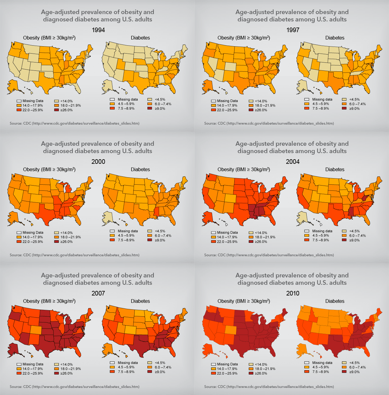
According to these maps, what is the apparent spatial correlation between obesity and diabetes?
Areas with higher rates of obesity tend to have higher rates of diabetes.
Areas with lower rates of obesity tend to have lower rates of diabetes.
In this modern era of climate change, how has the variability of weather been impacted?
Overall temperatures are rising worldwide. However, climate change has increased the variability of weather such that extremes like cold and and heat waves are more common (with heat waves more common than cold waves). Extremes in precipitation such as droughts and flood are more common as well (which is more common depends upon your location).

Based upon this climograph, what can you infer about this location's distance to equator and it's distance to ocean? Explain your reasoning.
Distance to equator: Must be relatively close to the equator because there is minimal temperature variation.
Distance to ocean: Must be relatively close to an ocean because there is minimal temperature variation.
Springfield, MO
C - mild mid-latitude climate
What is the continuum of the Six Americas? Which beliefs are the most common within the United States?
The Six Americas are a continuum of beliefs Americans hold about climate change. The continuum varies on the belief, concern, and motivation about climate change. Over 2/3 of Americans fall on the side of the continuum with more belief, more concern, and more motivation.