(Blank)
(Blank)
(Blank)
(Blank)
(Blank)
(Blank)
100
The Continent that we live on
North America
100
What shape is the earth?
a sphere
100
What is a hemisphere?
half a sphere
100
The state that I live in
Colorado
100
What is an ocean?
a large body of water
100
What do we call a mapmaker?
A cartographer
200
What is a compass rose?
a small drawing on a map that shows direction
200
The number of oceans on earth
5
200
The Intermediate directions are?
Northeast
Northwest
Southeast
Southwest
200
These are cardinal directions
North
South
East
West
200
The Northern most point on the globe is called this
North Pole
200
What is the capital of the United States?
Washington, DC
300
The number of continents
7
300
Line that splits the globe into Northern and Southern Hemispheres
Equator
300
Invisible Line that splits the globe into eastern and western hemispheres
Prime Meridian
300
The country that I live in
The United States
300
The Study of the world around us and its people is called:
Geography
300
What is the capital of Michigan?
Lansing
400
Name the 4 Key features every map needs
1) Title
2) Key/legend
3) Scale
4) Compass Rose
400
Name the 5 major oceans
Atlantic Ocean
Pacific Ocean
Indian Ocean
Southern Ocean
Arctic Ocean
400
A continent is:
A large mass of land
400
On a map key, what do we call the pictures that stand for something else?
Symbols
400
What is a key/legend?
something that tells what each symbol on the map stands for
400
An exact location on Earth is called
Absolute Location
500
List the continents
North America
South America
Europe
Asia
Australia
Antarctica
500
These lines run from west to east and are parallel to the equator
lines of latitude
500
This imaginary line is located a 0 degrees and runs East/West
The Equator
500
This runs North/South and is 0 degrees
What is Prime Meridian
500
These lines run north to south and measure the distance east or west of the Prime Meridian
lines of longitude
500
A location that is based on things it is near is called...
A relative location
600
What kind of map grid does the image show?
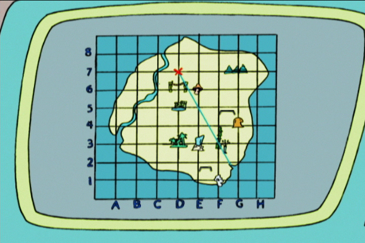
Coordinate grid
600
40 degrees North and 60 degrees West are absolute directions, and can be found in what hemisphere?
The NW hemisphere
600
Name the 5 oceans
Pacific, Atlantic, Indian, Southern, and Arctic
600
The part of a map that helps compare real distances to other distances on a map is called....
A map scale
600
The patterns of horizontal and vertical lines that crisscross are called...
Latitude and Longitude
600
Landforms such as mountains, river, plains, deserts, etc. are known as....
physical features