Map Terms
Landforms
Water Sources
Climate Regions
100
Found at the top of the map, tells you what the map is of.
What is the title?
100
A landform that rises very high above surrounding terrain and comes to a peak.
What is a mountain?
100
A network of stream and lakes that eventually form one river.
What is a river system?
100
Known for having high temperatures, high precipitation, and lots of biodiversity.
What is tropical?
200
The horizontal lines on a map.
What is lattitude?
200
A raised area of land that is flat on top. Often located in mountainous regions.
What is a plateau?
200
Any area of land where precipitation collects and drains off into a body of water.
What is a drainage basin?
200
Has more evaporation than precipitation, rocky and sandy surfaces, and is located close to the equator.
What is dry?
300
The vertical lines on a map.
What is longitude?
300
A low area between hills or mountains. Sometimes they have rivers flowing through them.
What is a valley?
300
A large body of freshwater surrounded by land.
What is a lake?
300
Located between a tropical and polar region, has 4 seasons, and has warm summers with mild winters.
What is temperate?
400
Tells you what colours and symbols on the map mean.
What is the legend?
400
An area of land that is surrounded by water, but is smaller than a continent.
What is an island?
400
Similar to a lake, but smaller and shallow.
What is a pond?
400
Known for having long, cold winters and extreme transitions between seasons. This climate region can be as cold as -30*C!
What is continental?
500
Gives you the relative measurements for distances on a map.
What is the scale?
500
A large natural stream of water that flows to another body of water.
What is a river?
500
A huge body of salt water.
What is an ocean?
500
The coldest climate region. It never exceeds 10*C and has very harsh conditions, making it difficult for any life to survive.
What is polar?
600
The invisible lines that divides the planet in half.
What is the equator?
600
A large moving body of ice that is very powerful.
What is a glacier?
600
This water source in Quebec is a vital drainage basin and necessary for fishing, agriculture, and shipping and receiving.
What is the St. Lawrence River?
600
This climate region got its name because it is similar to the climate in a portion of Europe.
What is continental?
700
The section of the world "above" the equator.
What is the northern hemisphere?
700
The height that a mountain must be at or above to not be considered a hill.
What is 600m?
700
Residential area, agriculture, and manufacturing lead to what in water systems?
What is pollution?
700
The climate region highlighted
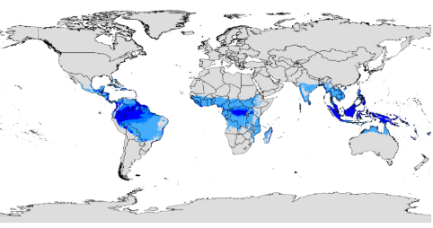
What is tropical?
800
The section of the world "below" the equator.
What is the southern hemisphere?
800
This releases magma and can result in the creation of plateaus.
What is a volcano?
800
The climate region highlighted 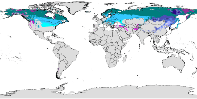
What is continental?
900
A feature that gives the cardinal directions.
What is the compass?