Cool Rules
Which Weather is Which?
Grabbag
Science!
Testbeds
100
The “online” platform to be used in 2020-21 by WPC for internal collaboration calls.
What is google meet?
100
This is another name for the energy method in forecasting precipitation type.
What is the Bourgouin Technique?
100
The “online” platform used to communicate Winter IDSS with the media and EMAs.
What is GoToWebinar?
100
Observations quality, forecast hour, presence of convection, and RAOB drift are examples of this when related to precip-type forecasting.
What is uncertainty?
100
Although we are informally participating in the CR weather messaging testbed, this is the CR testbed we are officially going to test this winter.
What is ESTF (Enhanced Short-Term Forecast)?
200
If we are fairly confident this is usually issued one to three days from an impactful winter storm.
What is a Winter Storm Watch?
200
This sounding is most likely an example of this type of precipitation?
What is freezing rain?
200
How often the WSSI web products (not static images) are updated.
What is 2 hours?
200
The number of probability catagories that WFO Nashville used for the NFL Draft and the CMA Awards IDSS.
What is 6?
200
The number of minutes after the hour that the ESTF maintenance mode is run during the ESTF testbed.
What is 20?
300
In an LSR for a Snow Squall, this must follow the word “Snow Squall”, nothing else.
What is a “period” { . }?
300
This sounding is most likely an example of this type of precipitation.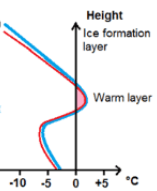
What is sleet?
300
The book by Annie Duke that was recommended by Chad Gravelle to improve your forecast process.
What is "Thinking in Bets"?
300
This GFE grid is used by both the top-down and Bourgouin precip-type forecast techniques by forecast builder.
What is ProbIcePresent?
300
The AWIPS procedure that is used to create winter messaging funnel products.
What is CreateStormImages?
400
This really drives home the message in a graphicast when winter weather conditions deteriorate.
What is a webcam image?
400
The process where ice crystals from a higher cloud deck fall into a lower cloud deck of supercooled droplets and change freezing drizzle to snow.
What is seeder-feeder?
400
This really drives home the message in a graphicast when winter weather conditions deteriorate.
What is a webcam image?
400
The precip-type approach that has the advantage of using more data sets than is available in AWIPS.
What is NBM 3.2/4.0?
400
The local application that is used to control the cadence of initializing the grids during the ESTF testbed
What is ESTF_Control?
500
The range of segment numbers used when blizzard conditions are mentioned in a Winter Storm Watch.
What is 100 to 199?
500
This sounding is most likely an example of this type of precipitation.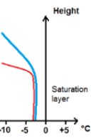
What is freezing drizzle?
500
This GFE grid is used by both the top-down and Bourgouin precip-type forecast techniques by forecast builder.
What is ProbIcePresent?
500
The definition of "Moderate Lift" when using the crosshairs technique with high resolution models.
What is 15 microbars per second?
500
The GFE database that is utilized by the ESTF maintenance mode to initialize the forecast database
What is ESTFBC?