Conversion
Grid coordinate
Map/ Navigation
Miscellaneous
50
How many kilometers (km) per grid square?
1000
1
10
100
1
50
 Using your declination diagram if you had a magnetic azimuth of 10 and want to convert it to a Grid azimuth what would be my azimuth?
16
50
Three minor terrain features are Cliff, Draw, and ____________
Spur
50
what are the three minor terrain features?
Draw, Spur, Cliff
75
What is the back azimuth of 70 degrees?
76 degrees
250 degrees
110 degrees
180 degrees
250 degrees
75
Using your declination diagram if you shot a magnetic azimuth of 90, and want to convert it to a Grid azimuth what would be my azimuth?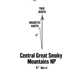
96
75
What are the three types of north?
True north, northwest, magnetic north.
True north, grid north, magnetic north.
True north, grid north, magnific north.
Total north, grid north, magnetic north
True north, grid north, magnetic north.
75
what does this color represent on the map?
MAN-MADE FEATURES, SUCH AS BUILDINGS AND ROADS.
100
The back azimuth of 348 degrees is 12 degrees. True or False?
False
100
How close will an eight-digit grid get you to your point?
100
10
1
100
10
100
How do you read a map?
Left and up.
Right and up
Up and right
Down and left.
Right and up
100
What is best to do if you become lost?
There is nothing you can do, wait until your unit or squad finds you.
Call 911
Use your back azimuth to the last known location.
Keep walking hoping you will get to the right location.
Use your back azimuth to the last known location.
200
How do you figure out a back azimuth?
Add 180 if 180 or less, subtract 180 if 181 or more
200
What is the distance between each grid coordinate ?
1000 m
200
This technique is less precise, but is faster to use and can be used under all conditions of visibility.
a. Center-Hold method
b. Hand-to-Chest method
c. Compass-to-Cheek method
d. Rear-to-Front-Sight method
Center-Hold method
200
Saddle
250
Using the Camp reply declination diagram. If you got a azimuth of 95 from one point to another using a map, but you want to convert it to magnetic north so you can use your compass to dead reckon what would the new azimuth be?
89
250
How close will a six-digit grid get you to your point?
100
250
This technique is used almost exclusively for sighting landmarks and is the best for taking an accurate azimuth bearing.
a. Center-Hold method
b. Hand-to-Chest method
c. Compass-to-Cheek method
d. Rear-to-Front Sight method
c. Compass-to-Cheek method
250
Hill