the natural features on Earth’s surface, such as landforms and bodies of water
Physical geography
What state is directly South of Minnesota?
Iowa
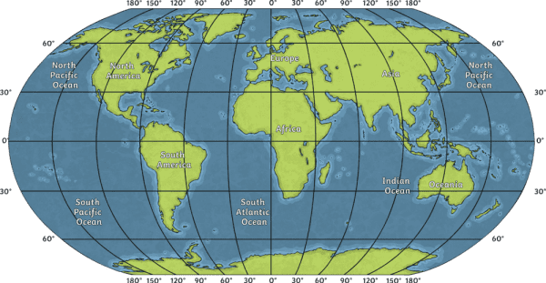
What latitudes cross over North America?

600 N and 300 N
What longitudes cross over Africa?

0 degrees and 300E
What does the black P represent on this map?

Playground
a measure of how far north or south a place on Earth is measured from the equator
Latitude
What state is two states East of Oklahoma?
Tennessee
What latitude is the Equator at?

0 degrees
What longitudes cross over South America?

600W
What does the yellow square represent on this map?

BBQ
a measure of how far east or west a place on Earth is from an imaginary line that runs between the North and South Poles
Longitude
If you were to travel from Utah to California, which direction would you be traveling?
West
What continents does the latitude 300S cross over?
South America, Africa, Australia
What continents does 1200W cross over?

North America and Antarctica
If you were looking for paths on the map, what symbol or color should you be looking for?

The grey line
the study of how people's lives and cultures are shaped by their physical geography
Cultural geography
If you were traveling from New York to Georgia, which direction would you be traveling?
South
What continents does 600N cross over?

North America, Europe, Asia
What continents does 600W cross over?

North and South America, Antarctica
If you were looking for the shelter, what symbol would you be looking for on this map?

The black square with the S inside.
a detailed representation of the natural and artificial features of an area, such as mountains and lakes.
Topography
If you were traveling from Washington to Florida, which direction would you be traveling?
Southeast
What continents does 600S cross over?

None!
 What longitudes cross over Asia?
600E, 900E, 1200E, 1500E
What is the difference between the dark green and the lighter green shading on the map?

The dark green is bushland, and the light green is grassland.