Vocabulary
Latitude/Longitude
Never Eat Soggy Waffles
Name that Map
Review
100
What are round representations of the earth called?
Globe
100
Horizontal gridlines on a map
Latitude lines
100
What are north, south, east, and west known as?
The Cardinal Directions
100
What type of map is this? How do you know?

Political map: shows the borders of countries and continents
100
What is the directional marker on a map called?
Compass Rose
200
What are flat representations of the earth called?
Map
200
Vertical gridlines on a map
Longitude lines
200
What are northeast, northwest, southeast, and southwest called?
The Intermediate Directions
200
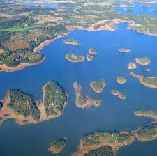
What type of map is this? How do you know?

Physical map: It shows physical landforms, in this case volcanoes
200
Name the 5 oceans
Arctic, Atlantic, Pacific, Indian, Southern
300
What explains the symbols on a map?
Map Key
300
The line of latitude that separates the northern and southern hemispheres is called the____?
Equator
300
How many time zones are in the world?
24
300
What type of map is this? How do you know?


Political Map: Shows borders
300
Name the 7 continents
Africa, Asia, South America, North America, Australia, Europe, Antarctica
400
What shows measurements on a map?
Map Scale
400
The line of latitude that separates the eastern and western hemispheres is called the____?
Prime Meridian
400
How many time zones are in the continental US?
4
400
What type of map is this? How do you know? 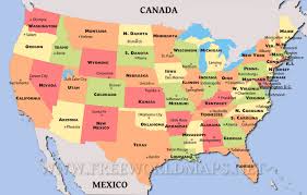
Political Map: Shows state borders
400
What are the 5 themes of geography?
Human environment interaction, location, place, region, movement
500
What are the colors, lines, and shapes on a map called?
Map symbols
500
Is Baltimore north or south of the Equator and east or west of the Prime Meridian? Careful, make sure you fully answer this question.
North of the Equator, West of the Prime Meridian
500
To travel from Baltimore to El Salvador, which Cardinal Direction would you most follow?
South
500
What type of map is this? How do you know? 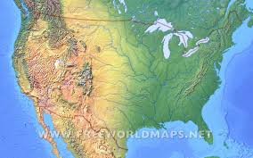
Physical map: Shows landforms, in this case mountains.
500
What is an archipelago?
A group of islands