Latitude/Longitude
Types of Maps/Projections
Remote Sensing
Reading Maps
100
Which line runs at 0 degrees latitude?
Equator
100
Why do flat maps distort shapes or areas of landmasses?
Earth is a curved, three-dimensional object.
100
What type of navigation is used by planes and ships?
GPS
100
What is a map legend?
It explains what the symbols on a map represent.
200
What is the latitude of the South Pole?
90 degrees South
200
What is the purpose of a topographic map?
It shows changes in elevation
200
How many GPS satellites are required to have an accurate signal?
3; the more satellites, the more accurate it is
200
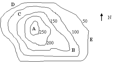
What is the change in elevation between B and A?
150
300
Give two differences between lines of latitude and longitude.
Latitude: parallel to equator and each other, do not converge, measure north to south, determine climate zones
Longitude: not parallel, converge at north and south poles, measure east to west, determine time zones
300
Which type of projection is used to make road maps?
Conic; it is most accurate for a specific area.
300
What is one thing landsat images can be used for?
Landsat data are used to study pollution, the movements of Earth’s plates, and the melting of glaciers and ice caps.
300
Why are map scales useful?
They show the relationship between distances on a map and actual distances on the surface of Earth, which enables the map reader to measure distances.
400
Infer why cartographers break down degrees of latitude and longitude into minutes and seconds.
Because a degree measures such a vast distance on Earth’s surface, cartographers break down the degree into minutes by dividing by 60 and further divide the minutes into seconds so that more precise locations can be pinpointed on a map.
400
Define index contours and depression contour lines.
Index contours: labeled with a number that indicates elevation
Depression contour lines: indicate change in direction of elevation change
400
How does the OSTM/Jason-2 satellite collect data?
The satellite sends radar waves to the ocean’s surface and picks up the echo that is reflected off the water. The distance to the water’s surface is calculated using the speed of light and the time it takes the signal to reach the surface and return. Variations in time indicate the presence of certain features on the ocean floor.
400
What is the difference between a graphic scale and a fractional scale?
Graphic: a line broken into sections that represent units with each section representing a distance on Earth’s surface
Fractional: a ratio that expresses distance, such as 1:50 000
500
Which line represents 180 degrees longitude?
International Date Line
500
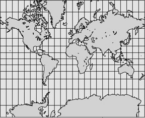
What type of projection is this? What are its limitations?
Mercator projection
Distorted areas of land masses
500
Infer how SeaBeam technology would be able to determine the possible location of an underwater mountain.
If sound waves were sent out by SeaBeam technology and their echoes came back in shorter amounts of time to a shortest point and then extending amounts of time, a scientist could assume the technology was picking up an underwater mountain.
500
If you were given a topographic map without index contours, what would you be able to infer? What could you not infer?
The map would indicate which points on the map were higher than others and which areas were steeper. It would not indicate the actual elevation of any point.