Parts of a Map
Kinds of Maps
Parts of a Map 2
How's Your Geography?
Random
100
It shows what the map is all about?
Title/ Map Title
100
This is a kind of map that shows streets and roads of a certain place.
Road Map
100
It shows the measurement of a place on the map in comparison to the actual size.
Map Scale/Scale
100
Your address is an example of what type of location?
Absolute Location
100
How do you call people who makes maps?
Cartographer
200
It shows the primary and secondary directions.
Compass Rose
200
This map shows the number of people or inhabitants living in a certain region or the thickly populated areas.
Population Map
200
It is an imaginary line that goes north to south, measuring 0 degrees and divides the earth into the western and eastern hemispheres.
Prime Meridian
200
I live across from the park" is an example of what type of location?
Relative Location
200
What kind of map gives information about products, resources, and kinds of livelihood of a particular place?
Economic Map
300
It is when the latitude lines and longitude lines meet and form squares.
Grid
300
This map shows the type of climate experienced in a certain area.
Climate Map
300
It is an imaginary line that goes west to east, measuring 0 degrees that divides the earth into the northern and southern hemispheres.
Equator
300
What continent does the USA sit on?
North America
300
What is a map?
It is a flat representation of the earth.
400
These are imaginary lines that go north to south.
Longitude Lines
400
This map shows the rivers, landscapes, and environments as they appear on Earth's surface.
Physical Map
400
It is the topmost and lowest end points of the earth.
Poles (North Pole and South Pole)
400
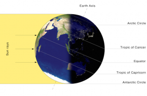
What season is the Southern Hemisphere in the diagram?
Summer
400
It shows the boundaries or extent of an area or a place. It may also show the different regions, provinces, cities and towns.
Political Map
500
These are imaginary lines that go west to east.
Latitude Lines
500
What is a topographical or physical map?
It is a map that shows the natural features of a place --- the water forms and the land forms.
500
It is an imaginary line that goes north to south measuring 180 degrees. This is used as a reference in changing the date and/or time.
International Date Line
500
What is the largest continent that lies in all 4 hemispheres?
Africa
500
What is a globe?
It is a spherical/round representation of the earth.