Location
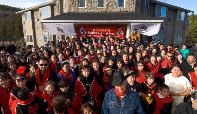
People
Eruption Facts
Climate and Vegetation
Fun Facts and Pictures
100
Mount Edziza is located in British Columbia, Canada
It is 409 miles from Alaska.
100
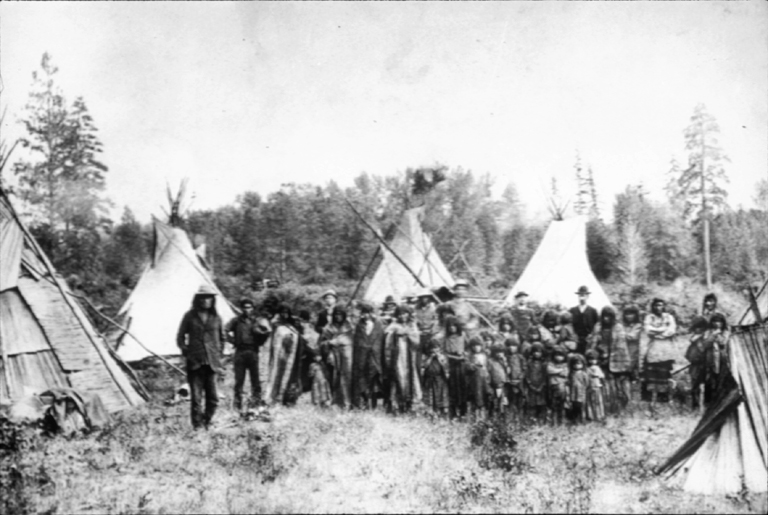
The Tahltan or Nahani Tribes live near Mount Edziza.
The Tahltan people.
100
The last eruption of Mount Edziza was in 950 CE (Common Era) which was 1000 years ago.
The volcano has not gone extinct, it is just dormant. The most recent eruption, which as I said was in 950 CE, was the most destructive eruption of Mount Edziza.
100
The typical climate of the area around Mount Edziza is very cold. For example, these are the averages for March through June:
March= 16°/ -9° F
April = 25° / 1° F
May = 35° / 9° F
June = 43° / 15° F
100
Mount Edziza is a Stratovolcano. (Provincial Park) Also, Mount Edziza is a part of the Northern Cordilleran Volcanic Province, which is a volcano arch/ belt.

200
Mount Edziza is in Stikine Country, British Columbia, Canada.
200
The closest permanent civilization to Mount Edziza is Iskut, BC, Canada.
Iskut is home to the Iskut First Nation, which is a group of Tahltan Tribe.
200
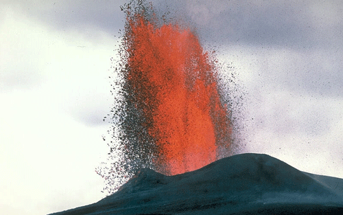
The eruptions of Mount Edziza range from rhyolite and basalt. The first picture is a rhyolite eruption and the second is a basalt eruption.

200
Around 1.5 million years ago, multiple glaciers started to form. The glaciers started to cut into the volcano peaks and as more and more of the glaciers formed, the temperatures got colder and colder in the surrounding areas.
On the peak of Mount Edziza, it snows often, and stays around 20-30°F this time of year.
200
Mount Edziza is made up of and surrounded by a lot of cinder cones and large lava flows that still keep their first forms.


300
Mount Edziza is located at 57.72° N Latitude and 360.63° W Longitude.
The elevation is 9140 ft. and the summit is 2786 m in the air.
300
The Iskut people live 40.7 km from the volcano.
300
Mount Edziza first starting erupting 10 million years ago.
In the last 10,000 years, it has erupted multiple times including: Desolation, Mess Lake, Snowshoe lava fields, Kana Cone, Eve Cone, Cinder Cliff, Icefall Cone, Ridge Cone, Williams Cone, and Walkout Creek.
300
British Columbia and Mount Edziza Provincial Park have lots of flowers, plants, and other wildlife.
Some of the most popular plants are Goatsbeard, Arrowwood Viburnum, Sword Fern, Deer Fern, and Common Elderberry.
300
The rocks are part of the Miocene to Holocene time periods. That means from 23.03 million years ago to 11,700 years ago.
400
It is 1,894 miles from Omaha, Nebraska.
Which is over 15 hours of driving.
400
The Tahltan people also go by Goon-da-chagga or Goon-tdar-shaga ("where the spring water stops")
The homes of the Tahltan were damaged badly by Mount Edziza's 950 CE eruption, and 2,000 people, including some Tahltan did die in the eruption.
400
Scientists aren't sure when Mount Edziza will next erupt, but the volcano has been associated with recent seismic activity.
This leads scientists to believe that even though they do not have an exact conclusion or time for the next eruption, Mount Edziza is potentially active and will erupt again soon.
400
When Mount Edziza erupted plants were burned and destroyed. They also didn't see sunlight for some time on a few occasions.
Now, if you look at the pictures, Mount Edziza is closely surrounded by rock. A little farther out, around 4-5 miles around the volcano, vegetation and plant life start to appear again.
400
Mount Edziza is the second largest volcano and volcanic complex in Canada.
Second only to the Level Mountain Range to the north of Mount Edziza.
500
A beautiful show of the spikes and peaks of Mount Edziza.

500
The Talhtan Tribe.
500
This picture gives you a view as to how there are multiple little volcanoes, such as cinder cones, surrounding the main peak.
500
This picture is around sunset.

500
A summer view of Mount Edziza. During different seasons, Mount Edziza is constantly colorful and different.
