Hazards caused by Weather 1
Hazards caused by Weather 2
Hazards caused by Plate Movement 1
Hazards caused by Plate Movement 2
100
A mobile and destructive vortex of violently rotating winds having the appearance of a funnel-shaped cloud.
Tornado
100
A tropical storm with winds that have reached a constant speed of 74 miles per hour or more.
Hurricane
100
Violent shaking of the ground as a result of movements within the earth's crust or volcanic action.
Earthquake
100
A long high sea wave caused by an earthquake or submarine landslide.
Tsunami
200
This graph shows the frequency of tropical storms & hurricanes in the Atlantic region. Study the data to answer the questions at right.
During which months are hurricanes and tropical storms most likely?

A. May and June
B. July and August
C. August, September, and October
D. November and December
C. August, September, and October
200
Which TWO construction methods would help mitigate destruction due to tornadoes?
A. Build a saferoom or shelter.
B. Use steel in the framework.
C. Use wooden shingles on a flat roof.
D. Use single-pane windows made of regular glass.
E. Keep debris from construction on the roof.
A. Build a saferoom or shelter.
B. Use steel in the framework.
200
According to geologists, an earthquake's destructiveness is primarily determined by which of the following?
A) The magnitude number alone
B) The time of day the earthquake occurs
C) The amount of energy released
D) The amplitude of the seismogram wiggle
C) The amount of energy released
200
This map shows the Ring of Fire. Study the data to answer the questions at right.
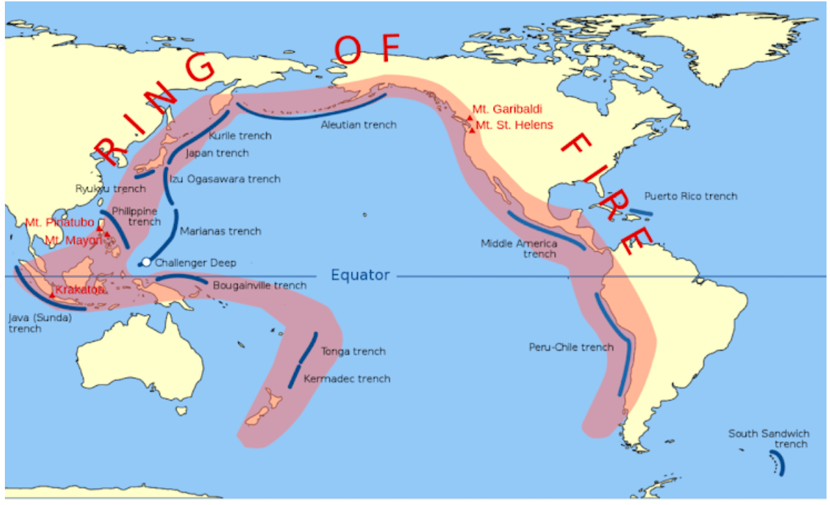
Tsunamis are most commonly experienced by people living on the coast of countries located on the Ring of Fire. Why?
A) Because the Pacific Ocean is the only body of water large enough to create waves that can reach the shore.
B) Because the Ring of Fire is a path along the Pacific Ocean characterized by active volcanoes and frequent earthquakes.
C) Because coastal areas in the Ring of Fire experience higher levels of rainfall and wind than other regions.
D) Because the equator passes through the Ring of Fire, causing the water to warm and expand into larger waves.
B) Because the Ring of Fire is a path along the Pacific Ocean characterized by active volcanoes and frequent earthquakes.
300
The image shows the three-day cone forecast of a hurricane. Four locations (I, II, III, IV) are labeled on the diagram.
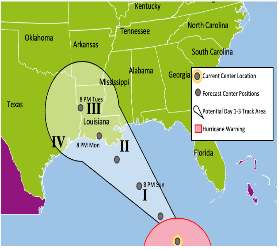
The hurricane center is MOST likely to be near location ___________ on Monday afternoon.
II
300
Given the data provided, which time of year is most likely to produce tornadoes in Georgia?

A. fall
B. spring
C. summer
D. winter
A. fall
300
The map shown would be useful in predicting the location of future

A. droughts.
B. earthquakes.
C. hurricanes.
D. mountain building.
B. earthquakes
300
According to the "Stay Safe" guidelines for during a volcanic eruption, which of the following actions should you take to protect yourself and your home
A) Get on the roof immediately to sweep away falling ash.
B) Drive your vehicle to higher ground to avoid lava flows.
C) Seek shelter and cover all ventilation openings, including sealing doors and windows.
D) Follow the "Drop, Cover, and Hold" protocol until the eruption stops.
C) Seek shelter and cover all ventilation openings, including sealing doors and windows.
400
Which location is MOST LIKELY to be struck by a hurricane?
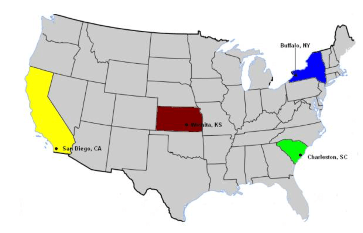
A. Charleston, South Carolina
B. San Diego, California
C. Buffalo, New York
D. Wichita, Kansas
B. San Diego, California
400
Which of the following statements explains why buildings in the northern United States usually have steeper roofs than buildings in the southern United States?
A. Minimal wind load in the North allow for steeper roofs, reducing the number of shingles needed on roofs.
B. Heavy snow loads in the North easily slide off steeper roofs, reducing the risk of roof collapse.
C. Steeper roofs have more surface area, which allows less heat to escape during the cold winter season.
D. Steeper roofs have tighter rafter joints, which leak less during the cold winter season.
B. Heavy snow loads in the North easily slide off steeper roofs, reducing the risk of roof collapse.
400
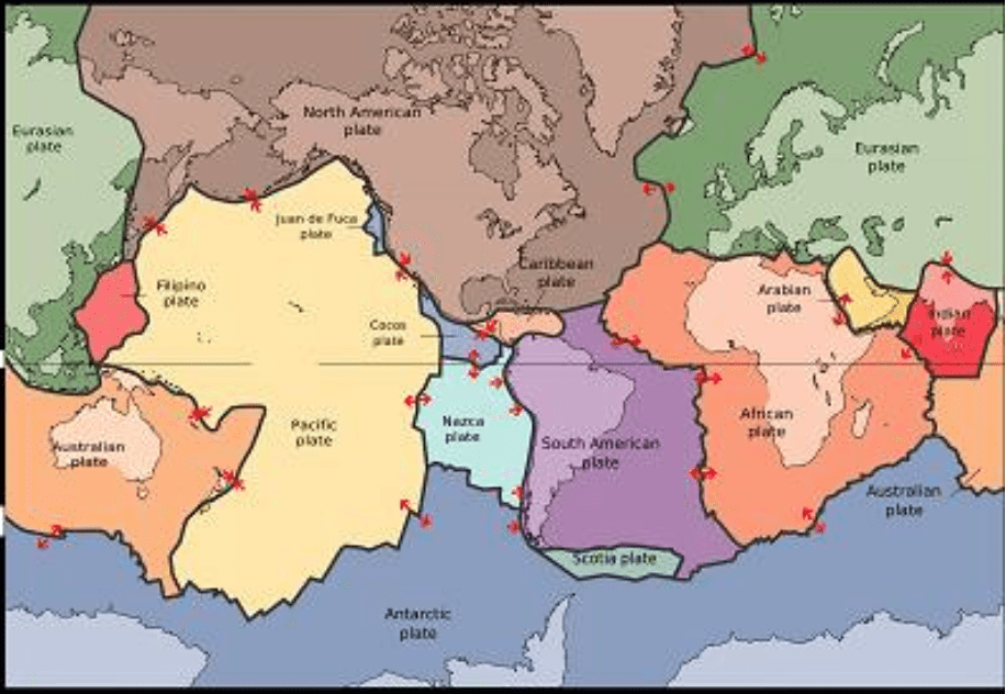
When looking at a map of Earth's tectonic plates, where would a scientist expect to find the highest concentration of active volcanoes and earthquakes?
A) Randomly scattered across the middle of the deepest oceans.
B) Along the boundaries (edges) where tectonic plates collide, pull apart, or slide past each other.
C) In the very center of large continents, far away from any ocean coasts.
D) Only near the equator, regardless of where the tectonic plates are located.
B) Along the boundaries where tectonic plates collide, pull apart, or slide past each other.
400
Considering Nepal is home to the highest mountains in the world, the Himalayas, why are they at risk for landslides?

A) The constant freezing and thawing of glacial ice within the deep mountain valleys.
B) High-density urban development and high-rise construction on the mountain peaks.
C) The presence of extremely steep slopes and fragile, tectonically active rock formations.
D) A complete lack of rainfall throughout the year, causing the soil to dry out and crumble.
C) The presence of extremely steep slopes and fragile, tectonically active rock formations.
500
A meteorologist is studying a hurricane forecast map showing a "cone of uncertainty." As the forecast looks further into the future (from Day 1 to Day 3), the white cone gets wider. What is the BEST explanation for this?
A) The hurricane is guaranteed to grow larger in physical size over time.
B) The storm will split into multiple smaller storms as it approaches land.
C) The exact path of the hurricane becomes harder to predict further into the future.
D) The wind speeds will continually increase and spread out over a wider area.
C) The exact path of the hurricane becomes harder to predict further into the future.
500
People living in coastal towns frequently face the natural hazard of storm surges and flooding. Which building modification would BEST help protect a new home from flood damage?
A) Building the house on a raised foundation or concrete stilts.
B) Planting large, heavy oak trees close to the roofline.
C) Painting the exterior of the house with water-resistant paint.
D) Installing single-paned glass windows to relieve water pressure.
A) Building the house on a raised foundation or concrete stilts.
500
Seismologist recorded all seismic activity globally for an entire year, using the data below which of the following patterns are they most likely to observe based on historical earthquake data?
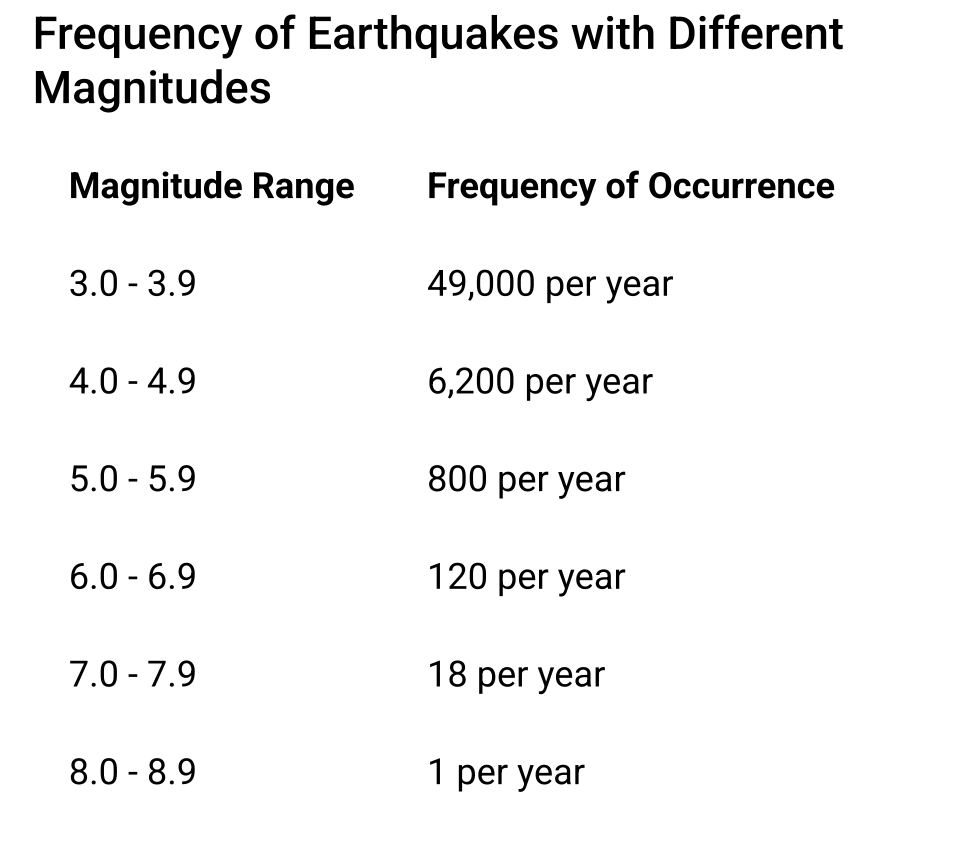
A) High-magnitude earthquakes happen much more frequently than low-magnitude ones.
B) Earthquakes of all magnitudes occur with the exact same frequency worldwide.
C) Earthquakes only occur when the magnitude reaches 5.0 or higher.
D) Low-magnitude earthquakes occur thousands of times a year, while high-magnitude ones are rare.
D) Low-magnitude earthquakes occur thousands of times a year, while high-magnitude ones are rare.
500
The map shows this data for four earthquakes.

When earthquakes have a magnitude of less than 7.0 and a depth over 100 kilometers below Earth's surface, they are not as likely to cause a tsunami. Scientists are analyzing the data from the four earthquakes on the map to determine which area needs to be alerted for a possible tsunami. Which earthquake location is MOST LIKELY to form a tsunami?
A. Earthquake One
B. Earthquake Two
C. Earthquake Three
D. Earthquake Four
D. Earthquake Four