Tools of Geography
Landforms and Waterways
A Spatial Way of Thinking
Five Themes of Geography
Vocabulary
Settlement Patterns in Canada
Survival of the Maya in Mesoamerica
100
The study of Earth and its people is called
A. geography
B. demography
C. geology
D. history
geography
100
What landform/waterway is A?
A. canyon
B. plateau
C. hill
D. bay
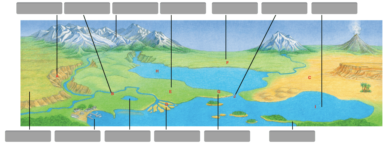
A. canyon
100
Geographers look at the world in spatial terms. This means
A. they only study how changes to Earth occur.
B. they examine why people choose to live in a certain place.
C. they look at how things are arranged relative to each other.
D. they prefer the use of maps to answer geographic questions.
they look at how things are arranged relative to each other.
100
Vietnam is in the northern hemisphere.
Movement
Region
Human/Environment Interaction
Location
Place
location
100
Maps can help us with the ____________of any place in the world.
absolute location
distortion
map projection
relative location
absolute location
100
An ecumene is a region that is well suited to permanent settlement. Which of these best defines Canada’s ecumene?
the border region
100
Maya judges often require a person who does something wrong to another person to
pay restitution
200
Physical geography is the study of
A. Earth and its people.
B. how things appear on a map.
C. people as they have spread across Earth.
D. natural features on the surface of Earth.
natural features on the surface of Earth.
200
What landform/waterway is B?
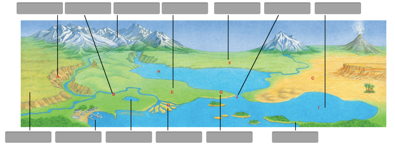
A. river
B. tributary
C. canyon
D. delta
A. river
200
Which of the following will you find on a map that shows physical features?
- A. businesses
- B. landforms
- C. population
- D. vegetation
- B. landforms
200
What languages are spoken in Brazil?
Movement
Region
Human/Environment Interaction
Location
Place
Place
200
There are seven of these giant landmasses.
A. plain
B. continent
C. plates
D. basin
B. continent
200
Ice skating on a frozen canal in winter is an example of how Canadians in Ottawa have
adapted to environment
200
Which term describes a group that has lived in an area since before it was taken over by outsiders?
Indigenous people
300
Which of the following is an example of human geography?
A. a city is built near a large river
B. a volcano erupts on a small island
C. a geographer examines a location on a map
D. a large mountain range separates two valleys
a city is built near a large river
300
What landform/waterway is C?
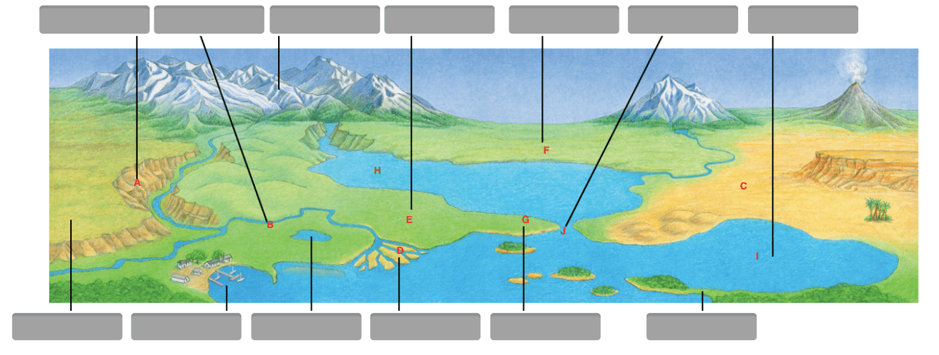
A. peninsula
B. basin
C. desert
D. hill
C. desert
300
Which term means the pattern of weather over a long period of time?
- A. climate
- B. density
- C. region
- D. vegetation
- A. climate
300
An area of earth with similar characteristics.
Movement
Region
Human/Environment Interaction
Location
Place
Region
300
The _________________of the building is three blocks away from the train station.
absolute location
relative location
map projection
distortion
relative location
300
Why were lighthouses first built in the Atlantic Region?
to avoid shipwrecks
300
How have Maya markets adapted to the modern world?
a. Food stalls are all together.
b. Markets are on Sunday.
c. Weavers offer old designs.
d. Money has replaced barter.
Money has replaced barter.
400
What does a map’s scale compare?
- A. direction on a map with direction on Earth
- B. distance on a map with distance on Earth
- C. location on a map with location on a globe
- D. distortion on a map with distortion on a globe
- B. distance on a map with distance on Earth
400
What landform/waterway is D?
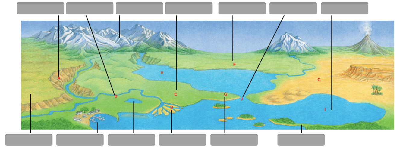
A. island
B. delta
C. lake
D. tributary
B. delta
400
What are coal, iron, uranium, and petroleum?
- A. land uses
- B. vegetation zones
- C. natural resources
- D. economic activities
- C. natural resources
400
Products made in China and shipped to the United States.
Movement
Region
Human/Environment Interaction
Location
Place
Movement
400
What are north, south, east, and west known as?
A. cardinal directions
B. GPS
C. GIS
D. location
A. cardinal directions
400
The castle-like buildings found in the Pacific Region show the influence of which of Canada’s founding peoples?
British
400
What has happened to traditional Maya religious beliefs in Guatemala?
a. They have disappeared.
b. They have replaced the Catholic faith.
c. They have blended with Catholicism.
d. They are followed in secret.
c. They have blended with Catholicism.
500
Which two continents are located entirely in the Western Hemisphere?
- A. Europe and Africa
- B. Asia and Antarctica
- C. North America and Australia
- D. North America and South America
- D. North America and South America
500
What landform/waterway is E?
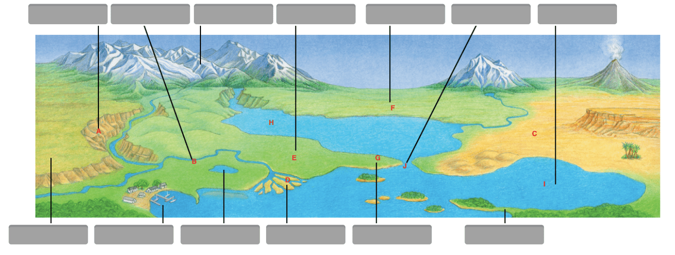
A. basin
B. desert
C. plateau
D. plain
D. plain
500
What does an economic activity map of a country show?
- A. where its people live
- B. what kind of climate it has
- C. how high its mountains are
- D. how its people make a living
- D. how its people make a living
500
Many states have to prepare for earthquakes and construct building that won't fall over.
Movement
Region
Human/Environment Interaction
Location
Place
Human/Environment Interaction
500
Another name for a map key
A. grid
B. basin
C. legend
D. hemisphere
C. legend
500
What is the main reason why so few people live in Canada’s Northern Region?
few resources
500
In which two countries do the Maya primarily live today?
a. Mexico and Guatemala
b. United States and Mexico
c. Venezuela and Bolivia
d. Brazil and Peru
a. Mexico and Guatemala
600
What does the relative location of a place tell you?
- A. the longitude and latitude of a place
- B. which symbol shows a place on a map
- C. where a place is compared to another place
- D. the map projection being used to show a place
- C. where a place is compared to another place
600
What landform/waterway is F?
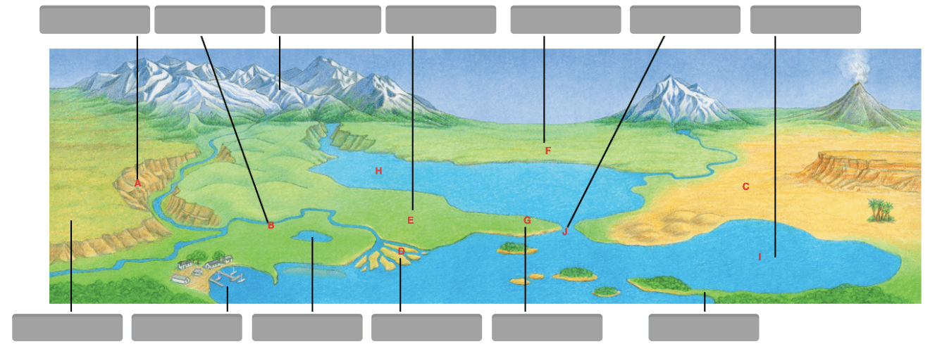
A. mesa
B. basin
C. plateau
D. hill
B. basin
600
What do geographers call an area with one or more features that set it apart from other areas?
- A. a city
- B. a region
- C. a landform
- D. a climate zone
- B. a region
600
Blue Valley Southwest
Movement
Region
Human/Environment Interaction
Location
Place
Region
600
Longitude labeled 0 degrees, from which all other degrees of longitude are measured.
A. equator
B. prime meridian
C. Tropic of Cancer
D. Tropic of Capricorn
B. prime meridian
600
True or False: Most Canadians live in rural areas.
False
600
Maya farmers have adapted to modern life by
a. harvesting more corn than any other produce.
b. using slash-and-burn method.
c. working for wages on commercial farms.
d. engaging in subsistence farming.
c. working for wages on commercial farms.
700
What do geographers use to indicate the absolute location of any place on Earth?
- A. a global grid
- B. a map legend
- C. a map scale
- D. a compass rose
- A. a global grid
700
What landform/waterway is G?
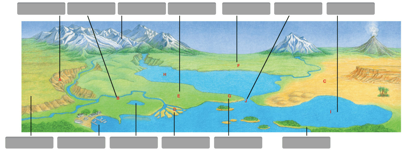
A. basin
B. peninsula
C. strait
D. island
B. peninsula
700
Flows from mountains and makes their way to the sea
- A. river
- B. mountain range
- C. basin
- D. isthmus
- E. bay
- F. canyon
- A. river
700
Amazon truck delivering packages.
Movement
Region
Human/Environment Interaction
Location
Place
Movement
700
A large area of Earth with a particular pattern of weather
A. vegetation zone
B. weather patterns
C. climate zone
D. vegetation patterns
C. climate zone
700
Which region has most of Canada's population?
Core
700
All of the following are traditional elements of a Maya home EXCEPT
a. construction of wood and adobe.
b. family altar for religious worship.
c. electric appliances such as a television and gas stoves.
d. a cook fire in the middle of the floor.
c. electric appliances such as a television and gas stoves.
800
A meridian of longitude is an imaginary line that runs
- A. parallel to the Arctic Circle.
- B. parallel to the Tropic of Cancer.
- C. from the North Pole to the South Pole.
- D. from the Prime Meridian to the International Date Line.
- C. from the North Pole to the South Pole.
800
What landform/waterway is H?
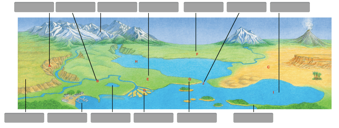
A. sea
B. strait
C. bay
D. lake
A. sea
800
Body of water that cuts deeply into shorelines and enclosed by land on 3 sides
- A. gulf
- B. mountain range
- C. isthmus
- D. plain
- E. peninsula
- F. canyon
- A. gulf
800
ABMS has the mascot of Wolverine and they wear green.
Movement
Region
Human/Environment Interaction
Location
Place
Place
800
Any action that relates to the making, buying, and selling of goods and services
A. regions
B. economic activity
C. elevation
D. climate zone
B. economic activity
800
Name the two official languages in Canada.
English and French
800
Which group is most likely to use the slash-and-burn method of clearing land?
a. commercial growers
b. migrant workers
c. plantation owners
d. subsistence farmers
d. subsistence farmers
900
Which of the following is the main advantage of the type of map projection shown below?
- A. It shows the area of oceans more accurately.
- B. It shows distances between places more accurately.
- C. It shows relative locations of places more accurately.
- D. It shows the size and shapes of continents more accurately.
- D. It shows the size and shapes of continents more accurately.
900
What landform/waterway is I?
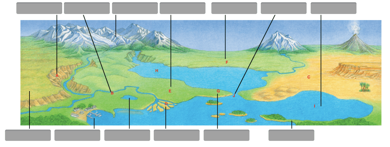
A. strait
B. lake
C. gulf
D. reef
C. gulf
900
Landform that is created from the weathering and erosion from water.
- A. gulf
- B. mountain range
- C. isthmus
- D. plain
- E. peninsula
- F. canyon
- F. canyon
900
Construction of the new gym at ABMS.
Movement
Region
Human/Environment Interaction
Location
Place
Human/Environment Interaction
900
A change in the shape or size of a place when Earth is represented on a flat map.
absolute location
distortion
map projection
relative location
Distortion
900
Name three uses of the land in Canada.
farming, fishing, forestry, livestock, and manufacturing
900
How do most Maya children learn traditional skills such as farming and weaving?
a. in village schools
b. from their parents
c. in municipal councils
d. from religious brotherhoods
b. from their parents
1000
Which two lines mark the northernmost and southernmost points where the sun’s rays ever beat straight down?
- A. the Arctic Circle and the Antarctic Circle
- B. the Tropic of Cancer and the Tropic of Capricorn
- C. the prime meridian and the International Date Line
- D. the prime meridian and the equator
- B. the Tropic of Cancer and the Tropic of Capricorn
1000
What landform/waterway is J?
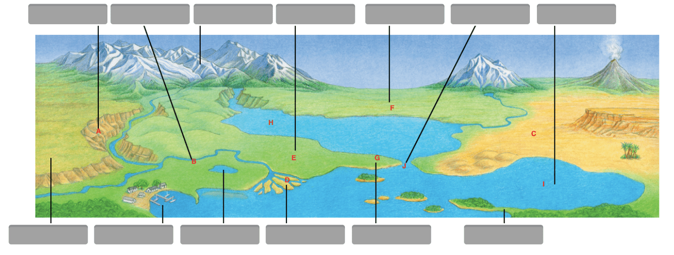
A. bay
B. peninsula
C. strait
D. delta
C. strait
1000
Landform that covers western Kansas.
- A. gulf
- B. mountain range
- C. isthmus
- D. plain
- E. peninsula
- F. canyon
- D. plain
1000
Urban Air one Metcalf Avenue.
Movement
Region
Human/Environment Interaction
Location
Place
Location
1000
Geographers choose the ___________________ that best suits the kind of information they want to present.
absolute location
relative location
map projection
distortion
map projection
1000
What are Canada’s five regions?
Pacific, Prairie, Northern, Core, and Atlantic
1000
Agriculture carried out mainly to provide food for farm families, with little surplus for sale to others.
a. traditional culture
b. subsistence farming
c. adaptation
d. indigenous peoples
b. subsistence farming