Intro to Phys. Ocean./ Solar energy
Thermohaline and wind-driven circulation
Waves
Tides
Wind/El Niño Activities
100
What is the name of the winds that transport warm, moist air from the Atlantic to the Caribbean, influencing hurricane and storm formation?
Trade winds
100
Which direction do cyclonic gyres move in the Northern Hemisphere?
Counter-clockwise
100
What is the correct interpretation of cotidal lines?
A. They connect locations that have the same tidal amplitude
B. They connect locations where high tide occurs simultaneously
C. They show the periodicity of the tides (in other words, the values on the contour lines show the number of hours between high tides at that location)
D. They show the frequency of the tides (in other words, the values on the contour lines show how many high tides occur per day at that location)
B. They connect locations where high tide occurs simultaneously
100
The horizontal distance between two successive wave crests or troughs is called the _______.
Wavelength
100
Which of the following best describes La Niña?
A) An event with weakened trade winds and eastward warm water movement.
B) A reversal of the Earth's climate.
C) Enhanced equatorial upwelling and stronger trade winds.
D) Widespread warming in the eastern Pacific.
C) Enhanced equatorial upwelling and stronger trade winds.
200
TRUE or FALSE: Rising air is associated with high pressure zones at Earth’s surface
False
Warm, rising air is associated with low pressure zones (e.g., equator)
200
True or false: Seawater density is affected by temperature, salinity, and pressure
True
Previously this asked about "potential Seawater density" Potential seawater density is only affected by Temperature and Salinity.
200
What are constructive, destructive, and mixed wave interference?
Constructive interference occurs when waves combine to create larger wave heights, while destructive interference occurs when waves cancel each other out, reducing wave height.
Mixed interference is where you have different heights and lengths overlap.
200
In Hawai‘i, we have Mixed Tides. This means that…
A. There are 12 hours and 25 minutes between consecutive high tides
B. There are 24 hours between consecutive high tides
C. There are 24 hours and 50 minutes between consecutive high tides
D. There are 6 hours between consecutive high tides
A. There are 12 hours and 25 minutes between consecutive high tides
200
What causes western intensification of the gyres?
Western intensification happens because the Coriolis effect increases with latitude, causing the poleward return flow in subtropical gyres to experience a stronger deflection than the equator-ward flow. To conserve vorticity, the ocean responds by strengthening and narrowing the western boundary current (like the Gulf Stream or Kuroshio), producing fast, deep western currents and broad, slow eastern currents.
300
Which of the following describes a Hadley cell?
a) Is directly driven by solar heating at the equator
b) Circulates air between 30° and 60° latitude
c) Operates at the poles
d) Transfers warm air from poles to equator
a) Is directly driven by solar heating at the equator
300
True or False: In the Southern Hemisphere a low pressure gradient and the Coriolis effect result in a clockwise subtropical gyre.
True
300
What happens as deep-water waves move into shallower water near shore? Do they become more or less steep? Use wave base to describe the transition.
Wave base (1/2 wavelength) disappears as the waves come into contact with the seafloor. Velocity decreases and they become steeper
300
What is the primary driver of internal waves?
A) Wind stress
B) Density differences at the pycnocline
C) Coriolis effect
D) Atmospheric pressure
B) Density differences at the pycnocline
300
What is the typical pressure gradient (at surface) of Walker Circulation?
A. Low pressure in the East Pacific, High Pressure in the West Pacific
B.Low pressure in the West Pacific, High Pressure in the East Pacific
C. Low Pressure in the East Pacific, Low Pressure in the West Pacific
D. High Pressure in the West Pacific, High Pressure in the East Pacific
B.Low pressure in the West Pacific, High Pressure in the East Pacific
400
What is albedo? Describe how it varies with latitude.
Albedo is the fraction of solar radiation reflected by a surface. An example of a surface with high albedo is snow.
Albedo is higher at high latitudes due to ice and snow, which reflect more solar radiation, and lower at low latitudes with less ice and more absorption by oceans and vegetation.
400
In which ocean is the oldest and most nutrient rich deep water in the world?
The Pacific
400
Describe the following for cold-core eddies and warm core eddies:
Divergence or convergence, rotation, nutrient levels, and upwelling or downwelling in Northern hemisphere.
Cold-core eddies are characterized by upwelling, divergence, counter clockwise rotation, and high nutrient levels.
Warm-core eddies are characterized by downwelling, convergence, low nutrient levels, and clockwise rotation.
400
How does the Moon affect tides?
A. Resultant forces between gravitational force and centripetal force, which produces tide-generating forces that are mirrored on opposite sides of Earth
B. The Moon’s rotation causes the tides
C. Gravity: the Moon pulls the ocean water toward it, which creates a single bulge that is high tide
D. The sun has a larger effect on the tides through the solar gravitational force
A. Resultant forces between gravitational force and centripetal force, which produces tide-generating forces that are mirrored on opposite sides of Earth
400
Which direction is the gyre from 0-40 S in between Australia and South America rotating?
A. Clockwise
B. Counter-clockwise

B. Counter-Clockwise
500
Explain how Earth's rotation creates the Coriolis effect. Describe how the Coriolis effect influences the direction of trade winds. Do hurricanes form at the equator?
Earth's eastward rotation causes objects in motion to be deflected to the right in the Northern Hemisphere and to the left in the Southern Hemisphere due to varying rotational velocities at different latitudes.
Rarely, there is no Coriolis effect at the equator, which is necessary for the rotation of a hurricane.
The Coriolis effect is strongest at the poles and nonexistent at the equator.
In the Northern Hemisphere, trade winds are deflected to the right (northeast), and in the Southern Hemisphere, they are deflected to the left (southeast).
500
Rank these from least to most dense
- AAIW (Antarctic Intermediate Water)
- NADW (North Atlantic Deep Water)
- NACSW (North Atlantic Central Surface Water)
- AABW (Antarctic Bottom Water)
- MIW (Mediterranean Intermediate Water)
NACSW – North Atlantic Central Surface Water (least dense)
AAIW – Antarctic Intermediate Water
MIW – Mediterranean Intermediate Water
NADW – North Atlantic Deep Water
AABW – Antarctic Bottom Water (most dense)
500
Most of the waves we observe on the surface of the ocean are generated by winds. Yet, even on a calm day with little/no wind, there can still be large waves breaking on a shoreline. Explain why.
Waves can be generated in a storm thousand of miles away and travel as swell.
500
What are the three Milanković cycles, what time scales do they operate on, and how do they influence Earth’s climate?
Milanković cycles consist of eccentricity, the change in Earth’s orbital shape every ~100,000 years; axial tilt (obliquity), the change in the angle of Earth’s axis every ~41,000 years; and precession, the wobble in Earth’s rotation every ~23,000 years. These cycles alter how sunlight is distributed across latitudes and seasons, influencing long-term climate patterns such as the timing of ice ages.
500
The map shows sea surface temperature (SST) anomalies in the tropical Pacific Ocean during the year 1997.
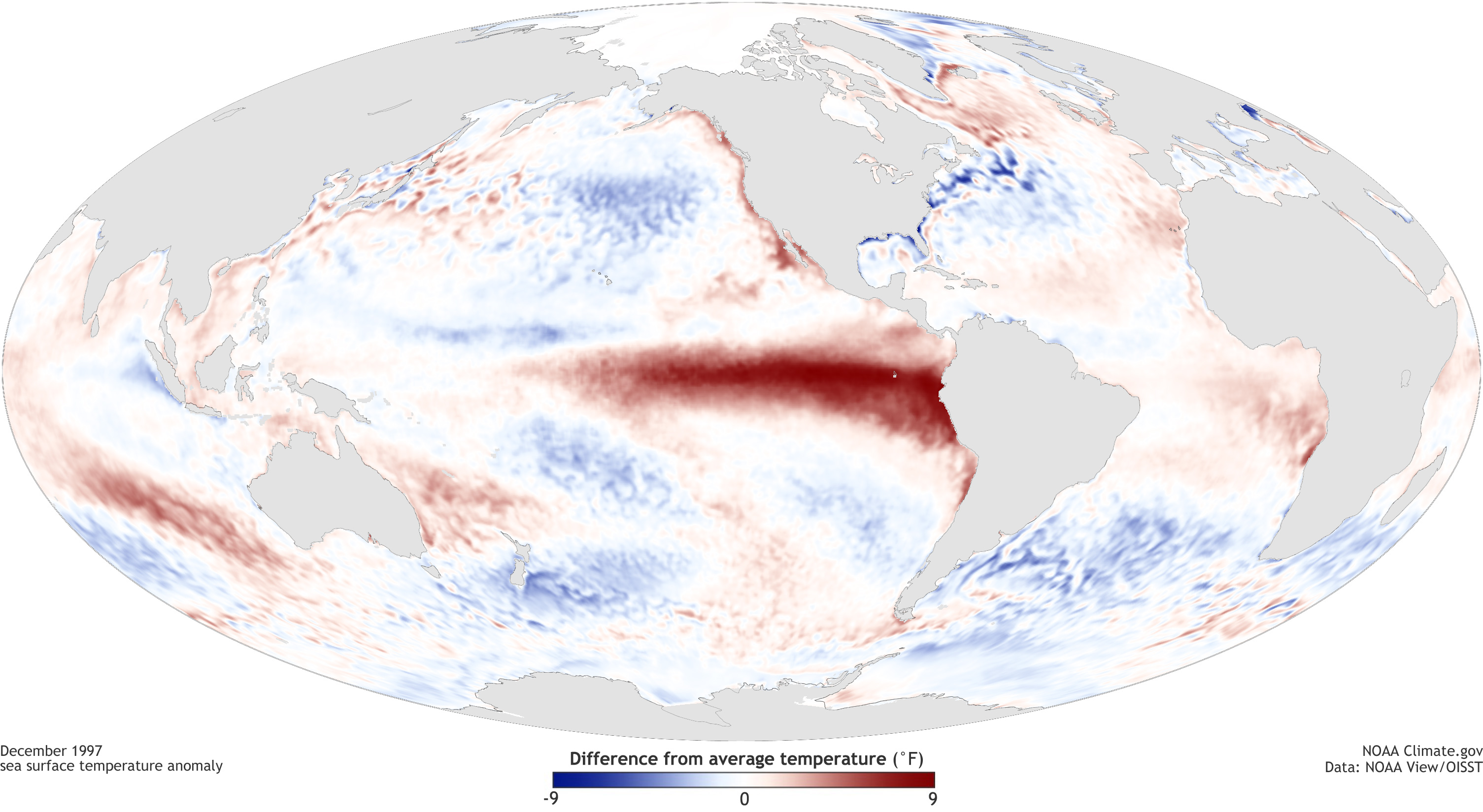
(1) Is this an El Nino event, La Nina event, or neutral conditions?
●
(2) Are the trade winds stronger or weaker than normal at this time?
(3) Is the thermocline in the eastern equatorial Pacific shallower or deeper than normal?
(4) Would countries in South America would receive more or less rainfall than normal?
1. El Niño event
2. Weaker
3. Deeper
4. More rain