A
B
C
D
E
100
Why under Emperor Hongwu, China prohibited maritime trade?
a.Prevent foreign influence and maintain control
b.COVID-19
c.Chicken pox
d.Scared the resources will be stolen
a.Prevent foreign influence and maintain control
100
How did researchers conserve the Selden Map of China?
a. Printed the digital copies
b. Put the map in glass frame
c. Added a linen backing to the map
d. Combining materials and techniques from East and West, to fix the previous faulty solution
d. Combining materials and techniques from East and West, to fix the previous faulty solution
100
After Zheng He’s final voyage, why did the Ming government discontinued the maritime expedition?
a. Rising Mongol threats
b. He is too old
c. Scared of nemo
d. Sea sick
a. Rising Mongol threats
100
What’s the name of our professor in this course?
a. Ilham Rahman
b. Marco Caboara
c. Marco Polo
d. John Selden
b. Marco Caboara
100
In the second commercial revolution of the Ming Dynasty, there was an emerging industry in Yangtze. What industry was it?
a. Semiconductor
b. Spices
c. Cotton & Textile
d. Titanium
c. Cotton & Textile
200
Why was Taiwan Important during the Ming Dynasty?
a. Important link in the route between South East Asia and Japan
b. Untapped Natural Resources
c. Major Military Stronghold
d. Spices and Narcotics
a. Important link in the route between South East Asia and Japan
200
Before the move of emperor Yongle, what is the capital city of China?
a. Nanjing
b. Beijing
c. Washington DC
d. Hong Kong
a. Nanjing
200
Which places (port) were NOT emigrated by the Chinese diaspora after Selden Map establishment?
a. Manila
b. Western Java
c. Australia
d. Nagasaki
c. Australia
200
Which port city is prominently featured on the Selden Map of China as a major maritime trading port, connecting to at least 16 routes in the South China Sea?
a. Shanghai
b. Quanzhou
c. Qingdao
d. Xiamen
b. Quanzhou
Note: There many navigations lines/routes are connected to Quanzhou on the map.
200
What is the size of the Selden Map?
a. 156cm x 96cm
b. 200cm x 90cm
c. 256cm x 116cm
d. 300cm x 210cm
a. 156cm x 96cm
300
What is the island inside the rectangle?
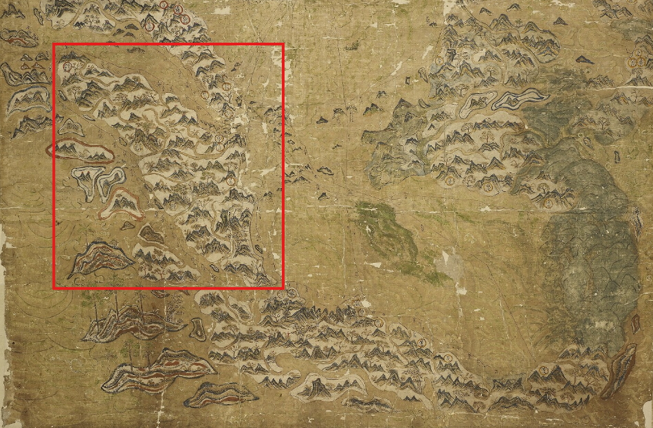
a. Taiwan
b. Luzon
c. Java
d. Sumatra
d. Sumatra
300
What was the primary purpose of the Selden Map of China?
a. Used by ancient Chinese astronomers to chart the positions of stars and planets
b. A blueprint for the construction of the Great Wall of China
c. Showing trade routes during the Ming Dynasty period, used by merchants
d. To fulfill the dynasty’s command
c. Showing trade routes during the Ming Dynasty period, used by merchants
300
What are the regions depicted in the map?
a. Antarctic region and its wildlife
b. Ancient mythology, such as Atlantis and El Dorado
c. Mainland China, South East Asia, Japan and Korea
d. Europe, South America, and North America
c. Mainland China, South East Asia, Japan and Korea
300
What was NOT the influence of the Selden Map during the Ming Dynasty (Based on reading material)?
a. The widespread of Western religion
b. Influx of new food
c. Development of Chinese Blue and White Porcelain
d. The popularity of John Selden & Li Dan
d. The popularity of John Selden & Li Dan
300
When was the Selden Map of China created?
a. 13th century
b. At the end of the Ming Dynasty’s Wanly era and Beginning of Tianqi era
c. 500 AD during Han Dynasty
d. Early 20th century
b. At the end of the Ming Dynasty’s Wanly era and Beginning of Tianqi era
400
What does the Selden Map indicate about the landscape and local products of South East Asia?
a. It shows only the types of animals found in the region
b. It depicts various species of trees and plants that correspond to different geographical areas
c. It focuses solely on mineral resources.
d. Nothing, it only highlights the routes sailing along the coast of Southeast Asia.
b. It depicts various species of trees and plants that correspond to different geographical areas
Note: There is cedar, plum, willow, bamboo, camphor, pine, and palm on the map
400
Where is the image of the sun in the Seldon map?
a. Lower left edge
b. Upper left edge
c. Upper right edge
d. There is no sun
c. Upper right edge
400
According to the scale of the Selden Map, how long would it take for a voyage from Manila to Brunei? (if it is travelling at normal speed. (1 geng = 2.4 hours)
a. 32 geng
b. 82 geng
c. 42 geng
d. 62 geng
d. 62 geng
400
What areas did the trunk route depicted on the map pass through?
a. Java Island, Vietnam, Philippines
b. South Korea, Taiwan, Hong Kong and Indonesia, Singapore, Malaysia
c. Fujian, Nagasaki, Hirado, Central Vietnam and Quanzhou, Manila
d. Sapporo, Tokyo, Hiroshima, Northern Vietnam
c. Fujian, Nagasaki, Hirado, Central Vietnam and Quanzhou, Manila
400
What other Chinese maps depicted the correct geographic location and topology of China?
a. Ming Sea and Yu Ji Tu maps
b. Fra Mauro Map
c. Tianxia jiubian fenye renji lucheng quantu
d. Atlas Map
a. Ming Sea maps and Yu Ji Tu maps
500
What was special of the Selden Map of China compared to other nautical chinese maps (e.g. the Zheng He Nautical Chart)
a. It incorporate crucial Western cartography elements such as compass bearings and ratios
b. The first map to include the detailed information about distance between places
c. Exclusively design the routes for maritime war
d. It use the Eastern mapping technology at that time
a. It incorporate crucial Western cartography elements such as compass bearings and ratios
500
What was found in the back of the Seldon map?
a. Sketch of a scale, navigation points, and a diagram showing the shipping routes
b. Sketch of a mountain, navigation points, Compass
c. Compass, diagram of shipping routes, Moon and Sun
d. Sketch of a scale, navigation points, Sketch of moon and sun
a. Sketch of a scale, navigation points, and a diagram showing the shipping rout
500
What does the blank square to the right of the compass rose on the Selden Map most likely to represent?
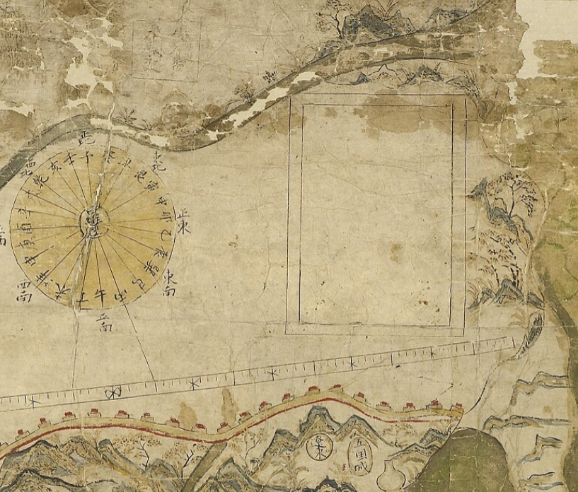
a. An unfinished geographic object of the map
b. An unfinished legend of the map
c. A decorative element only
d. The map itself
d. The map itself
Note: There is a hypothesis that the blank square is for emphasizing the map's purpose as a navigational tool, where understanding the difference between "compass north" (magnetic north) and "map north" (true north) was crucial.
500
Which of the following is NOT a common practice of Fujianese vessels involved in smuggling?
a. Sailing along the coast while appearing to be shallow, flat-bottomed boats
b. Surrounding the bulwark with a bamboo fence for wave protection.
c. Carrying at least two to three days of food and water supplies to survive in long distance sailing
d. Transforming into seafaring vessels once out of sight of law-enforcement officials.
c. Carrying at least two to three days of food and water supplies to survive in long distance sailing
Note: Under the Ming government, it is illegal to bring more than two days of food and water supplies. Merchants exploit it by getting supply in Taiwan instead.
500
What was the prominent characteristic of Selden Map of China compared to that of other typical chinese maps?
a. Covered more vast areas of oceans and Island, and only give ⅓ space to mainland China
b. The oldest map in the world
c. It depicted China as the center of the world
d. Clearly mapped all of the natural resources in the world in detailed
a. Covered more vast areas of oceans and Island, and only give ⅓ space to mainland China