Temperature & Air Masses
Pressure & Fronts
Wind
Climate & Unique Weather Occurrences
Miscellaneous
100
As temperature increases, in an open system, this is what density of a gas does.
What is decreases?
100
This type of front extends northwest from location Y.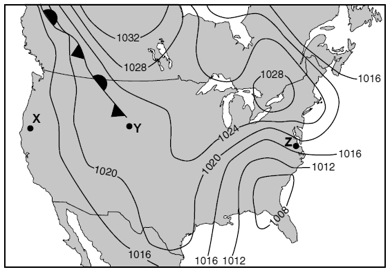
What is a stationary front?
100
The uneven heating of the Earth by the sun and the Earth's own rotation, resulting in varied temperatures and pressures, result in this movement of the air.
What is "wind?"
100
This is the long-term pattern of weather in a particular region.
What is climate?
100
Boarding up windows would be one emergency action most likely taken to prepare for which natural disaster?
Earthquake, Hurricane, Flood, or Tsunami?
What is hurricane?
200
Generally, this is a cold air mass that originated over land.
What is continental polar?
OR What is cP?
(Continental arctic, cA, would also be accepted in certain scenarios, but cP is more common, especially concerning local weather.)
200
This is the kind of front that involves interaction between three air masses instead of just two air masses.
What is occluded front?
200
This is used to measure wind velocity.
What is an anemometer?
200
A rotating funnel cloud that stretches down and touches the ground is called this.
What is a tornado?
200
This gas in Earth's mid-to-upper atmosphere is beneficial to humans because it absorbs large amounts of ultraviolet radiation.
What is ozone? (O3)
300
This is the two-letter weather map symbol for the type of air mass that would originally form over the Gulf of Mexico and move up into the United States.
What is mT?
300
The map shows a composite of Doppler radar images. Darker shadings indicate the precipitation pattern of a large storm system. The air is rising overall. The surface wind circulation pattern around the center of this storm system is described by these two directions.
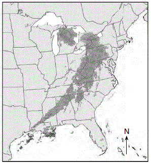
What are inward and counter-clockwise?
[Half-credit for only one of them.]
300
Gases move from areas of ___________ to areas of ____________, resulting in wind.
What is (areas of) high pressure to (areas of) low pressure?
300
A climate or region characterized by a lot of rainstorms likely has a lot of these kinds of pressure systems pass through.
What are low pressure systems?
OR What are cyclones?
300
These are the three sources of hurricane damage.
What are, in some order, the following?: storm surge (from waves), inland flooding (from rain), wind
[Partial credit allowed.]
400
Of the following diagrams, which one represents a cold front? 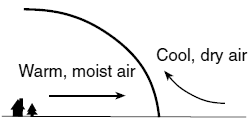
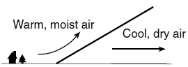
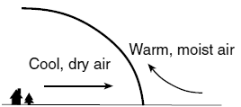
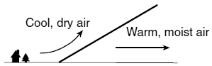
What is... this one?
400
This piece of map information indicates that the wind velocity is greater at location Z than at location X.
What is something akin to "The isobars are closer together at Z?"
400
The weather map below shows a storm centered north of Iceland. Isobars are labeled in millibars. Of A, B, C, and D, this point was probably experiencing the highest wind speed.
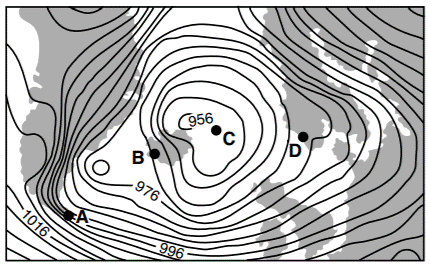
What is A?
400
All hurricanes start as this and decline back into this.
What is tropical storm?
400
Planetary winds in the northern hemisphere are deflected to the right due to this phenomenon.
What is the Coriolis Effect?
500
The map shows a low-pressure system. Between points U, V, W, X, Y, and Z, these two most likely have the warmest air temperatures. 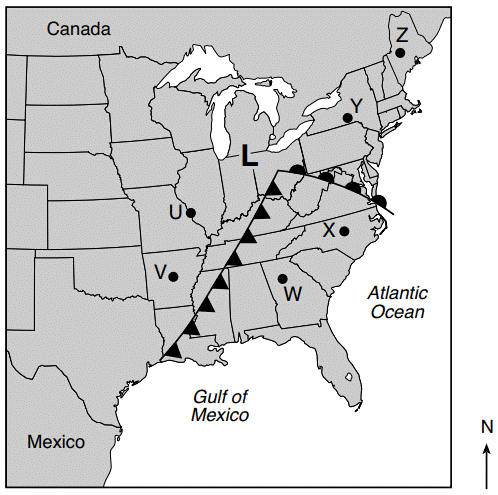
What are W & X?
(Half-credit if only one correct point)
500
If the center of the low-pressure system follows a normal storm track, toward which labeled city would the center of this low least likely move?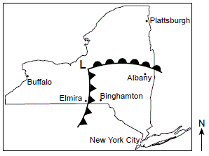
What is Buffalo?
500
The weather map below shows air-pressure readings given in millibars. Points A, B, C, and D are locations on Earth’s surface. This location is where surface wind speed is the lowest.
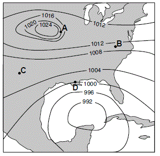
What is C?
500
Tornadoes commonly occur between these two US mountain ranges.
What are the Rocky Mountains & the Appalachian Mountains?
[Partial credit allowed]
500
These changes in air temperature and atmospheric pressure will normally be recorded by a weather balloon when it is released at Earth’s surface and rises through the troposphere.
What is a decrease in both air temperature and atmospheric pressure?
[Partial credit allowed]