COLOR me crazy
History of TOPO
LEGEND R US
SCALES that don't Weigh
Randoms
100
Dense vegetation on a topo map is what color?
Dark Green
100
Detailed paper map that defines an area.
Topographical Map
100
Map reading clues and navigational data.
Map Legend
100
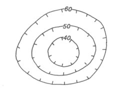
Steepness of Terrain is shown through this visual cue.
Contour Lines
100
Depressions are marked with a circle containing tic marks.
200
Blue shading on a topo describes what?
Streams and lakes
200
Large scales and small scales are often confused.
True or False
True: Large scale means greater detail; small scale means less detail.
200
This elevation interval info is found in your map legend.
Contour interval
200
Steep vs Gradual describes?
Slope
200
In previous years this tool was required to use a topo map.
A Compass
300
Light or colorless areas on a topo map.
Open Terrain
300
Every map has a representative scale similar to the one's on a road map. 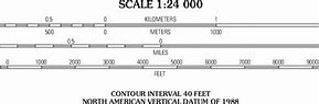
This scale is a distance calculation with information and a visual grid.
300
The example of 1:24,000 scale means
1 inch on the map equals _ inches in terrain.
24,000 inches
300
Every 5th contour line is thicker. Why?
Used as index for elevation.
Index Contour Line
300
How do you improve on reading a topo map?
Practice
400
Brown markings on a TOPO map are the most common. What do they define?
Contour lines and elevations
400
What does USGS stand for?
United States Geological Survey.
400
1 to 24,000 vs 1 to 65,000 on the Legend which scale has less detail?
1 to 65,000; the larger the scale the less detail.
400
True or False:
Elevation from one line to the next line on a contour interval is the same on every map.
False: it's only the same on the map that you are referencing.
400
Magnetic North is a key piece of information. Where is it found and what does it describe?
It is referenced on the legend and found on the compass. Magnetic North is the compass pull to the Earth's magnetic field.
500
Purple defines what data point on a topo map?
Revisions made to the map using aerial photography but not yet verified by field checked.
500
Online resources of topo maps are more common today. List 2 advantages to this resource.
Accessibility by phone and frequent updates.
"Downsides are limited trail information and lack of infield verification"
500
Map Legends include Magnetic Declination for what purpose?
Magnetic Declination is required for compass use.
500
What are the normal feet for contour intervals?
_ to_
40 to 80 ft
500
All Legends are exactly the same.
True or False
False: Maps come from many different sources including specialty companies, mapping websites and local map makers.