What are the lines on a map we use to measure how far away from the equator a place is? They run East to West.
What are latitude lines
What is an example of our important latitude lines?
What is the: Arctic Circle, Tropic of Cancer, Equator, Tropic of Capricorn, and the Antarctic Circle.
What is an example of our important longitude lines?
The Prime Meridian or the International Date Line.
What is the tool on a map that displays the 4 cardinal directions: North, South, East, and West?
What is a Compass Rose.
What are the lines on a map the measure how far we are from the Prime Meridian? They run North to South.
What are longitude lines.
What Continent is Barcelona, Spain located in?
What is the European Continent.
What continent is Lima, Peru located in?
What is South America
Cairo, Egypt is located in this continent.
What is Africa
Beijing, China is in this continent.
What is Asia?
New York City, NY appears in this continent.
What is North America?
What type of map is often colorful and shows the lines people used to divide countries and states for the purpose to govern people. It even shows cities.
What is a Political Map.
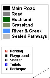
 What is a tool on a map that explains the symbols, colors, and patterns that appear on the map?
What is a map legend/key.
What type of map shows features such as mountains, deserts, lakes, canyons, and rivers.
What is a physical map.
What is the temperature like near the equator?
What is hot, humid, and tropical
What type of map displays the type of weather found in the area?
What is a Climate Map.
What are the latitude and longitude coordinates for Moscow, Russia?
What is 55 Degrees North and 37 degrees East.
What are the latitude and longitude coordinates for Perth, Australia?
What is 32 Degrees South and 115 Degrees East.
What are the latitude and longitude coordinates for Caracas, Venezuela?
What is 10 degrees north, 65 degrees West.
What are the latitude and longitude coordinates for Mogadishu, Somalia?
What is 2 degrees North and 45 degrees East.
What is the latitude and longitude for Istanbul, Turkey?
What is about 41 degrees North and 29 Degrees East.
What type of map displays a land's height using lines. It is used to compare the height of land to other surrounding land areas?
What is a contour map.
The tropic of Cancer is located at ____ degrees North.
What is 23.5
What type of map displays how the land pictured is being used? This map may show vegetation, mining, crops, etc.
What is a Land Resource Map.
The Antarctic circle is located at ___ degrees south
What is 66.3 degrees south.
What type of map uses colors to show the height of land above sea level?
What is an Elevation Map.