Vocabulary1
Describe It
Relative or Absolute
Map Types
FACTS
100
Sharing an edge or boundary.
1) Geography
2) Kingdom
3) Contiguous
3) CONTIGUOUS
Synonyms: adjacent, neighboring
100
Give ONE an example of a LANDFORM.
ISLAND
MOUNTAIN
PENINSULA
ICE SHELF
100
An exact location spot or location on Earth.
ABSOLUTE LOCATION
100
1) True
2) False
Is a ROAD MAP a good example of a GENERAL PURPOSE MAP?1) True
Road maps are used navigation vs. data.
General Purpose map is used for the general purpose of finding one's way around.
100
HOW MANY STATES ARE PART OF THE CONTIGUOUS U.S.?
1) 10
2) 50
3) 48
3) 48
48 states touch each other, plus the District of Columbia. It does not include Alaska, Hawaii, Puerto Rico or other U.S. territories.
200
Tells you the SUBJECT of a map.
1) Climate
2) Title
3) Geography
2) Title
200
Give ONE example of a waterway
BAY
SEA
OCEAN
SOUND
200
Archimedes Academy is located at 456 White Plains Road, Bronx, NY 10475.
ABSOLUTE
200
What is Ms. Denise's last name?
HAND
200
Which theme of geography is about how people adapt & change their environment is known as
1) movement
2) location
3) human environment interaction
4) none of the above
3) human environment interaction
300
A supreme ruler, especially a monarch (king or queen).
KINGDOM
300
The imaginary line that runs around the center of the Earth at zero degrees latitude (East / West).
EQUATOR
300
Which type of location are we using when using these words:
near / far from
east of
over / under
RELATIVE LOCATION
300
A map displaying/showing patterns or distributions such as climate, population, and transportation.
THEMATIC MAP
300
Name ONE of the FIVE themes of geography.
LOCATION, PLACE
HUMAN ENVIRONMENT INTERACTION
REGION, or MOVEMENT
400
A BUILDING OCCUPIED BY A COMMUNITY OF MONKS LIVING UNDER RELIGIOUS VOWS.
MONASTERY
400
Describe the PRIME MERIDIAN.
The prime meridian is an _________ line that runs from _______ to ______ poles at ______ degrees _____________.
The prime meridian is an imaginary line that runs from NORTH to SOUTH poles at zero degrees longitude.
400
Missouri is in the Midwest of the United States, bordered by Illinois, Kentucky, Tennessee, Arkansas, Oklahoma, Kansas, Nebraska, and Iowa.
RELATIVE LOCATION
400
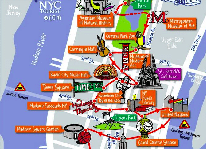 This is used by tourists, what is the correct map type?
GENERAL PURPOSE
400
Name ALL FIVE themes of geography
LOCATION, PLACE
HUMAN ENVIRONMENT INTERACTION
REGION
MOVEMENT
500
TO ENCLOSE SOMETHING
ENCAPSULATE
500
Flat and measures how fat the earth is. Like a baseball player when he’s swinging a bat. It goes east to west.
LATITUDE
500
Identified by specific coordinates, such as latitude and longitude.
DOUBLE POINTS with an example.
ABSOLUTE LOCATION
500
What type of map is this?
This map uses color to show distribution and density of selected information. Blue = Republican Party and Red = Democratic Party
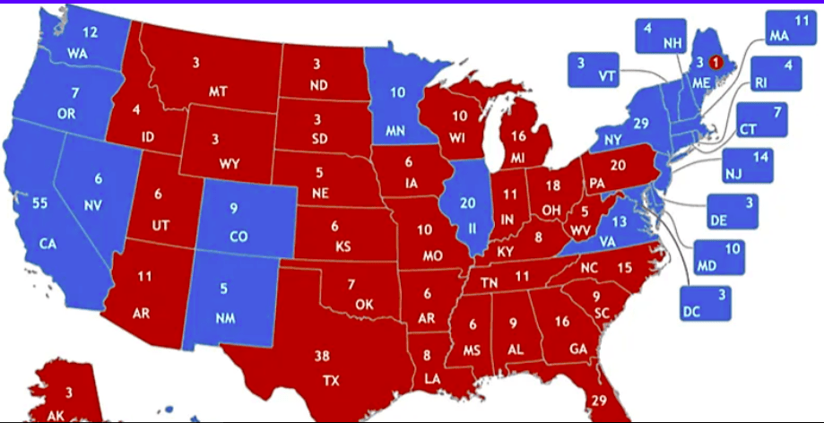
THEMATIC use symbols, colors and patterns.
Location: Coastal areas with risk for flooding.
Does NOT show location of spatial features.
Not for navigation or finding your way.
500
Name ONE of the the U.S. territories that aren't included in the 48 contiguous states.
DOUBLE POINTS IF YOU CAN NAME ALL THREE.
Alaska
Hawaii
Puerto Rico