Map It Out!
Globe Trotters
Graph Gurus
Mountains to Marshes
Spot the Patterns
100
A map that shows the natural features and landforms of an area is called a what?
Physical Map
100
These imaginary line runs east to west, parallel to the equator.
Lines of Latitude.
100
This type of graph, which can be used to display population by continent, is divided into pieces that represent part of a whole.
Pie Graph/Pie Chart
100
What is the largest freshwater lake in Florida?
Lake Okeechobee
100
A map that shows cities, boundaries, highways, schools, or parks is known as this.
Political Map
200
This type of map shows the weather patterns of area, such as rainfall or temperature.
Climate Map
200
This line of longitude at 0 degrees divides the Earth into east and west hemispheres.
Prime Meridian
200
This type of chart uses an x-axis and y-axis to display a series of points connected together.
Line Graph
200
This desert in the Southwest region of the Unites Stated is known for being one of the hottest in North America.
Mojave Desert
200
The system that stores, analyzes, and presents many types of geographic data, like the image pictured below, is known as this.
Geographic Information System (GIS)
300
A person who makes maps is called a what?
Cartographer
300
This Washington town is located at approximately 48N, 122W.

Everett, WA
300
This type of graph uses an x-axis and y-axis and is used to compare categories, such as average rainfall over a period of several months.
Bar Graph
300
Name the mountain range that stretches from Alabama to Canada.
Appalachian Mountains
300
An area with one or more common shared characteristics is known as this.
Region
400
What tool on a map shows how distances on the map compare to distances on Earth?
Map Scale
400
Columbia, SC is located at what coordinates of latitude and longitude?
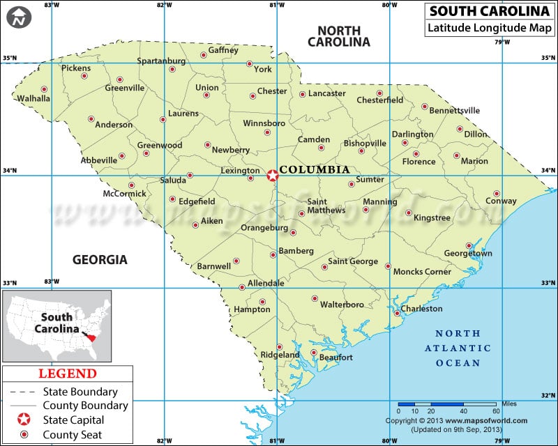
34N, 81W
400
Using the graph below, what can be said about the population of the United States between the years of 1900 and 2000?

The population has steadily increased over time
400
This river runs almost 2,350 miles from Minnesota to the Gulf of Mexico.
Mississippi River
400
An area that is owned or controlled by the government, but does not have equal status with other regions.
Territory
500
This term describes how many or how few people live on a specific amount of land.
Population Density
500
Miami is located at about 26N, 80W. Which hemispheres is it in?
Northern and Western Hemispheres
500
Which month had the second highest level of rainfall?

August
500
This vast stretch of grassland covers about one-third of the United States and some portions of Canada.
The Great Plains
500
Which two geographic tools divide the Earth into hemispheres?
Equator and Prime Meridian