Maps and Location
Geographic Data
Spatial Concepts
Human-Environment Interaction
Scale and Regional Analysis
250
It's the name of the type of thematic map shown below.
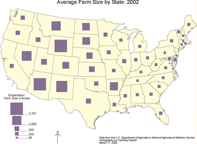
What is a graduated symbol map?
What is a proportional symbol map?
250
The geographic data shown here was collected through this process.
What is remote sensing?
250
A Syrian family immigrating to the U.S. and continuing to practice their culture privately without spreading it to others would be an example of this type of diffusion.
What is relocation diffusion?
250
This belief claims that the physical environment controls human cultural development.
What is environmental determinism?
250
The scale of analysis shown in the map below.

What is national?
250
Every map projection has some degree of distortion because a curved surface cannot be represented on a flat surface without distortion. Of the types of map distortion, this one is represented by the 'A' in the acronym SADD.
What is area? (land area)
250
If the government wanted a better understanding of the income distribution across the country, they would likely use data from this source.
What is the census?
250
When studying the map below, the spatial pattern of public libraries in Nevada can best be described this way.

What is dispersed?
250
The lush golf courses in the United Arab Emirates, the dikes and polders in the Netherlands, and the Great Man-Made River in Libya are significant examples of land use that reflects this concept.
What is possibilism?
250
A geographer is comparing population clusters that occur around the central business districts of major cities would benefit most by using this scale of analysis.
What is local?
250
Latitude and longitude may be used to determine this characteristic of a point on the earth.
What is absolute location?
250
According to the data found in the map below, the highest concentration of dairy farms in the U.S. exists in this physical region.
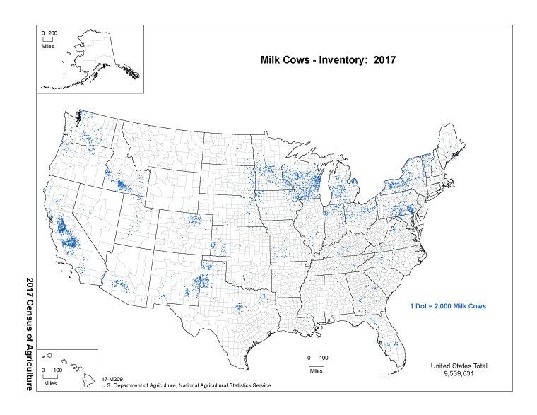
What is the Great Lakes?
250
Functional regions often exhibit this geographic concept of things becoming less related as they get further away from each other.
What is distance decay?
250
An increase in the use of electric vehicles, because they do not consume fossil fuels and their reduced emissions result in less environmental pollution best reflects this environmental concept.
What is sustainability?
250
A map that is zoomed in to show the spatial pattern of parking spaces at a Trader Joe's cartographically could be described as being this.
What is large scale?
250
The geographic scale of the map below.

What is regional?
250
The U.S. owns twenty-four of these specific objects orbiting earth transmitting complex radio codes, including time signals traveling at the speed of light. You can contact at least 4 of the 24 objects at any time of day or night for precise location that includes elevation.
What are GPS satellites?
250
The name of the model that helps to explain the spatial arrangements of high density hearths, such as economic or cultural hearths, that have less dense or less developed areas surrounding them.
What is the core-periphery model?
250
The map below shows the best land in the U.S. for agriculture. The least amount of suitable agricultural land can be found in this region of the U.S., which is also the driest.

What is the west?
250
A milkshed is this type of region in which fresh milk is produced and can be delivered without spoilage for sale and consumption. A dairy farm sits at the center of an area, the size of which is determined by how far fresh milk can be shipped and still maintain shelf-life for consumers.
What is functional (nodal)?
250
Left and right are relative, but North, South, East, and West are examples of absolute this.
What is direction?
250
Multiple data points on a map occurring near each other would likely be described this way by a geographer.
What is clustered?
250
There is an established network of migration from Asia and Latin America to the United States. The heavy use of this network across time creates this spatial phenomenon.
What is a flow?
250
This essential human activity engages in all 4 of earth's systems (biosphere, atmosphere, lithosphere, hydrosphere).
What is agriculture?
250
The political geographic divisions within a country can best be described as these types of regions.
What is formal (uniform)?