Intro to Maps
Geographic Data
Spatial Concepts
Human-Environmental Interaction
Scales of Analysis & Regional Analysis
100
What is the precise point where a place is located on Earth?
absolute location
100
Data that describes certain attributes and help us understand the "why" or "how" which is gathered through observation and interviews
Qualitative Data
100
What is the term that means "relating to space"?
Spatial
100
the study of how humans interact or adapt to the environment
cultural ecology
100
shows small area with large amounts of data
Large scale map
200
A map where the sizes of countries are shown according to a specific variable
Cartogram
200
How often is the US Census
every 10 years
200
The name of a location
toponym
200
materials or substances that occur in nature and can be used for economic gain
natural resources
200
Identify the type of region
functional or nodal region
300
What 4 things are distorted by map projections?
Shape, Area, Distance, Direction
300
Describe two examples of field observations/fieldwork.
written accounts, travel narratives, media reports, policy documents, interviews, photographs, landscape analysis
300
the wavelike spread of ideas, moving through space without regard to hierarchy
contagious diffusion
300
Acknowledges the limitations imposed by the natural environment, but focuses on the role of human culture to modify and respond to the environment to better fit human needs.
possibilism
300
Identify the name of region 19.

Eastern Europe
400
A map that uses lines that connect points of equal value to depict variations in the data across space. Used for weather
Isoline
400
a computer system/software that stores, analyzes, and displays information from multiple digital maps or data sets
GIS, Geographic Information Systems
400
The interaction between two places declines as the distance between two places increases
Distance Decay
400
The belief that climate and landforms are the most powerful forces shaping human behavior and societal/cultural development.
environmental determinism
400
Identify the name of region 15.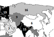
South Asia

500
Which map projection shows the accurate size of countries but creates inaccurate shapes?
Peters projection
500
the use of cameras or other sensors mounted on aircrafts or satellites to collect digital images of the earth's surface
remote sensing
500
occurs when a specific trait is rejected but the underlying idea is accepted
stimulus diffusion
500
using Earth's resources in ways that ensure their availability for future generations
Sustainability
500
what are the four traits that could unify a formal region
economic, social, political, environmental