Great Lakes
River Raisin
Climate Change
Hydrographs
Miscellaneous
100
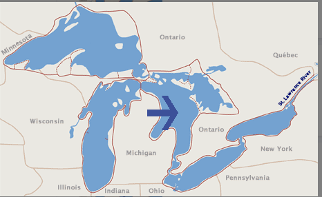
Lake Huron
100
What is the predominant type of land use in the River Raisin watershed?
Agriculture
100
Name two greenhouse gases.
carbon dioxide CO2
methane CH4
nitrous oxide N2O
sulfur dioxide SO2
100
How long did the rain last? 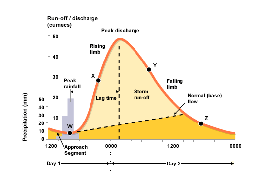
About 4 hours
100
B
200
Name the correct Great Lake:
1. highest elevation
2. shallowest
3. deepest
1. Lake Superior
2. Lake Erie
3. Lake Superior
200
Where are the headwaters of the River Raisin located?
Irish Hills - Onsted Area
200
What are two ways humans increase the amount of greenhouse gases in the atmosphere?
1. burn fossil fuels
2. deforestation
3. livestock farming
200
How long did it take the river to crest after peak rainfall?
About 10 hours
200
Where would the discharge be the least in the given diagram?
A
300
Identify each of the following:
1. Body of water between Lake Superior and Lake Huron
2. 3 bodies of water (in order) between Lake Huron and Lake Erie
1. St. Mary's River
2. St. Clair River - Lake St. Clair - Detroit River
300
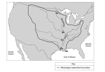
Name the 6 counties that the River Raisin Watershed encompasses
Lenawee
Washtenaw
Monroe
Fulton
Hillsdale
Jackson
300
What are three "sinks" of carbon? In other words, where is carbon stored when it is removed from the atmosphere?

1. Soil
2. Vegetation (trees)
3. Oceans
4. Shells
300
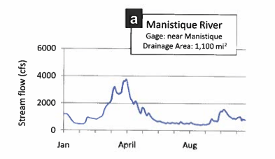
Is the Manistee River considered flashy or flat? Explain your response.

Flat. There is very little fluctuation in water levels throughout the year.
300
What are two factors that will increase the amount of runoff in an area?
1. Increase the slope of the land
2. Decrease the vegetation
3. Increase the amount of pavement
400
Name the 8 States that border the Great Lakes.

Wisconsin, Minnesota, Michigan, Illinois, New York, Ohio, Pennsylvania, Indiana
400
Answer the following:
1. The River Raisin is approximately the size of what state?
2. What Great Lake does the River Raisin empty into?
3. What type of contaminant is found at the mouth of the River Raisin?
1. Rhode Island
2. Lake Erie
3. PCB
400
Climate data hasn't always been recorded, therefore scientists use proxy data. Name one piece of data they use to get the proxy climate numbers?
ice cores, tree rings, coral growth
400
What is the most likely cause for the increase in discharge seen during April?
Give one physical reason pertaining to the river's structure that could cause the river's volume to fluctuate so much during that time.
1. Snow melt
2. ground still frozen, soil doesn't allow infiltration
400
Answer the following questions:
1. What percentage of the world's water is freshwater?
2. What % of all freshwater is found in the Great Lakes?
3. What government agency is responsible for ensuring the safety of the US drinking water?
1. 3%
2. 20%
3. EPA
500
Identify each of the following:
1. Great Lake with longest shoreline
2. Great Lake Niagara Falls dumps into
3. Great Lake Erie Canal connects to Atlantic Ocean
4. Great Lake entirely within U.S.
5. Only Great Lake that does not touch Michigan
1. Huron
2. Ontario
3. Erie
4. Michigan
5. Ontario
500
Answer these questions regarding the River Raisin:
1. City that gets its drinking water from River Raisin
2. Approximate number of wastewater treatment plants in River Raisin Watershed
3. Major tributary of River Raisin
4. What is the approximate length of the River Raisin?
1. Deerfield, Adrian, Blissfield
2. 20-25
3. Saline River
4. 139 miles
500
Melting sea ice produces positive feedback on global warming. Explain how it does this?
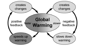
As sea ice decreases, so does the albedo effect. With less ice, less of the sun's rays are reflected and therefore the planet warms more.
500
Why is the right side of the graph wider than the left side? Name a factor that would cause this to occur.
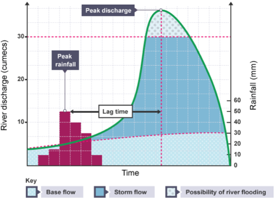
The ground is already saturated from the rainfall event, therefore, it will take longer for the water to percolate into the soil.
500
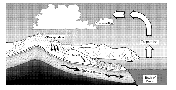
Water moves throughout a watershed using the water cycle.
1. Describe one way water moves into a watershed.
2. Describe one way water moves out of a watershed
1. Precipitation, Groundwater Discharge
2. Evaporation, Direct pumping (Nestle Corp w/Ice Mtn.)