Hemispheres
Lines of Latitude
Continents & Oceans
Analogies
Vocabulary
100
What Hemisphere is the United States in? hint: find the BEST answer
A. Northern Hemisphere
B. North West Hemisphere
C. South West Hemisphere
D. Eastern Hemisphere
B. North WEST hemisphere
(If you just put northern make sure you're more specific on the test
100
What is the name of the line that runs side to side through the middle of the earth?
A. Prime Meridian
B. Tropic of Cancer
C. Equator
C. Equator!
100

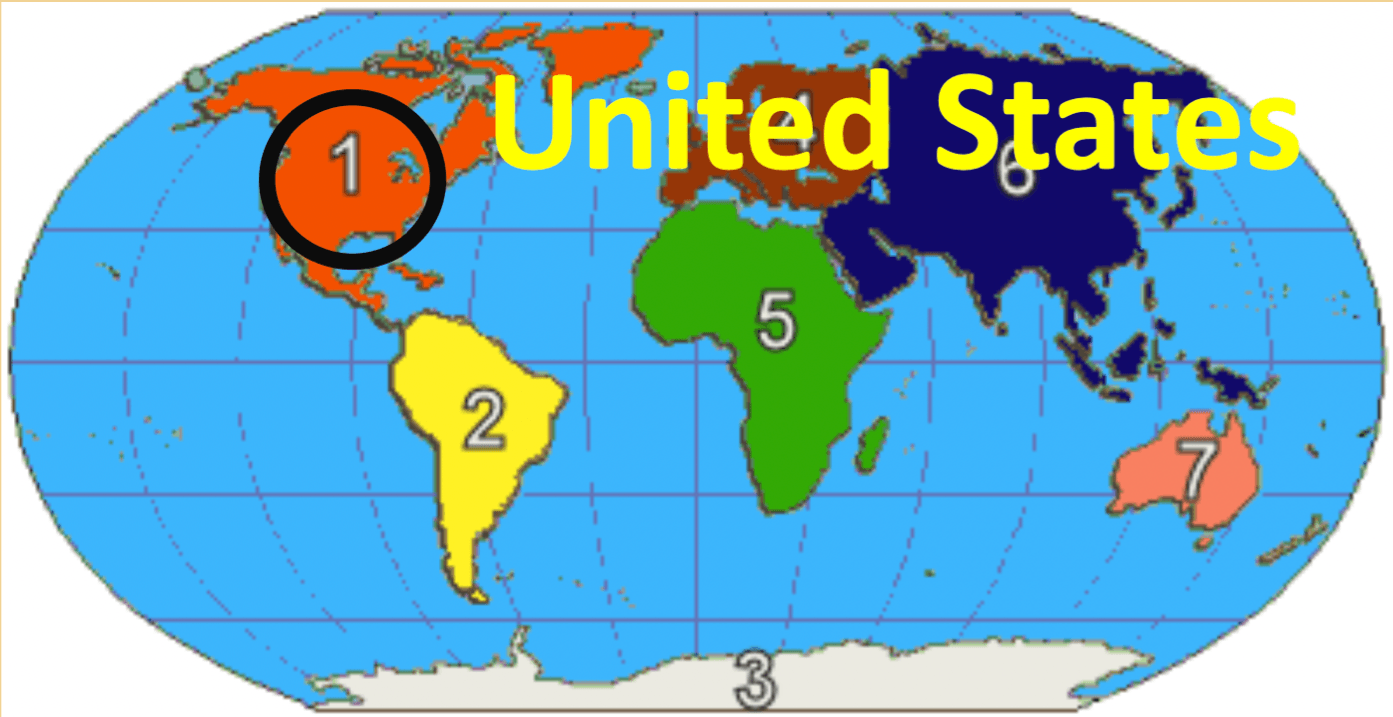
What is the name of continent number 1?
A. Europe
B. Africa
C. Asia
D. North America
D!
100
Mars is to planet as Milky Way is to _____?
A. City
B. Galaxy
C. Star
D. Continent
B. Galaxy
100
Which of the following best represents "Natural Resources"
A. Air, forests, water, fossil fuels etc.
B. Weather conditions prevailing in an area
C. Exact spot on earth where something is
A. Air, forests, water, fossil fuels etc.
200

What Hemisphere is AUSTRALIA located in?
A. North West
B. South East
C. South West
D. North East
South EAST!
200
Which line runs up and down through the middle of the earth?
A. Equator
B. Tropic of Capricorn
C. Prime Meridian
Prime Meridian!
200
What is the name of continent #4
A. Asia
B. Africa
C. Europe
D. South America
C!
200
Eagle Springs is to neighborhood as Texas is to _____
A. State
B. Country
C. Town
D. Continent
A. STATE
Texas is called the Lone Star STATE for a reason
200
Which of the following best represents an economic resource map?
A. display information based on an area's natural resources available or economic activity
B. a map that shows landforms, bodies of water, and other geographical features
C. a map that shows boundaries of countries, states, and counties, the location of major cities, and others
A. display information based on an area's natural resources available or economic activity
300

Which continent can be considered to be in 3 different hemispheres?
A. Asia
B. South America
C. Europe
D. Africa
Africa!
300
What is line #6 referred to as?
A. Prime Meridian
B. Tropic of Cancer
C. Antarctic Circle
D. Arctic Circle
D. The arctic circle!
300
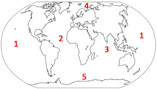
What is the name of the ocean for ocean #1
A. Atlantic
B. Southern Ocean
C. Arctic Ocean
D. Pacific Ocean
Be specific it's the .... PACIFIC
300
Houston is to city as ______ is to country
A. Texas
B. United States
C. South America
D. Humble
B. United States
300
Which of the following best represents "Population Density"?
A. the location of something in comparison to the location of something else (ex. Culvers is across from CVS)
B. a map that shows boundaries of countries, states, and counties, the location of major cities, and others
C. the average number of people living within a square mile - how crowded a place is
400
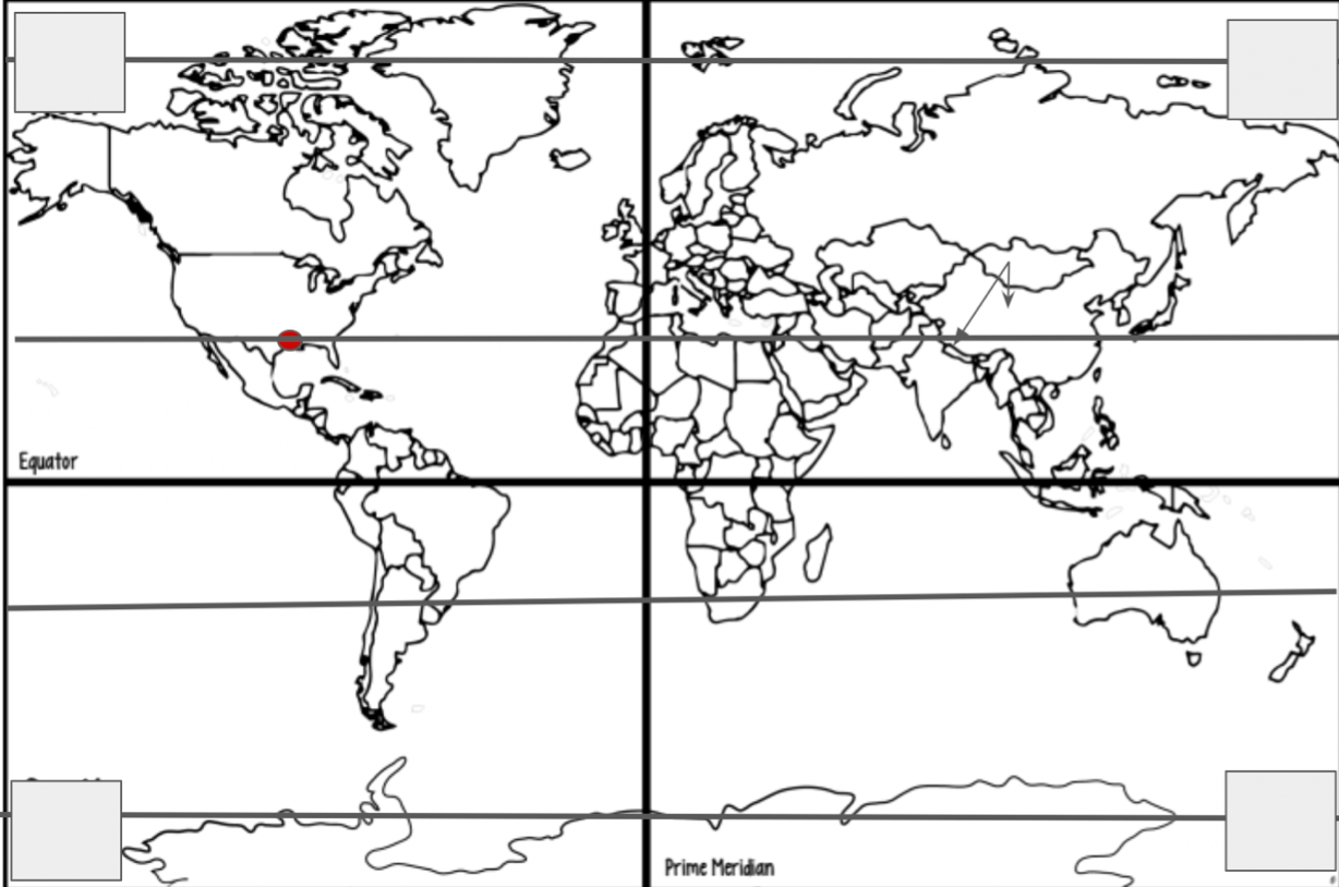
Which Hemisphere's does South America cross into?
A. North East and South East
B. North West and South West
C. South East and North West
D. North East and South West
B. North West and South West!
400

What line of latitude is #3 ?
A. Tropic of Capricorn
B. Equator
C. Tropic of Cancer
D. Arctic Circle
Tropic of Capricorn
400
What is #6 called?
A. Russia
B. Africa
C. Asia
D. Australia
C. Asia!
400
What is bigger than a neighborhood BUT smaller than a city?
A. State
B. Country
C. Town
D. Continent
Town!
400
Which of the following best describes a "Climate Map"?
A. a map that shows landforms, bodies of water, and other geographical features
B. the weather conditions prevailing in an area in general or over a long period of time. Example:temperature, precipitation (rain), desert, cold, ect.
C. display information based on an area's natural resources available or economic activity
D. the study of the natural features of the Earth such as landforms, climate, plants, and animals,
B. the weather conditions prevailing in an area in general or over a long period of time. Example:temperature, precipitation (rain), desert, cold, ect.
500
Which Hemisphere is the EQUATOR in?
A. Northern
B. Southern
C. South Eastern
D. None of the above
D. None of the above! It is actually in the Northern AND the Southern since it's at the center of the earth.
500

Which 3 continents does Line 3 pass through?
A. Argentina, South Africa, and Australia
B. South America, Africa, and Australia
C. North America, Africa, Asia
D. Africa, Australia, North America
Line
B!
500

Which ocean is ocean #3
A. Southern Ocean
B. Indian Ocean
C. Midwest Ocean
D. Atlantic Ocean
B. Indian Ocean
500
There are six continents on our planet
A. True
B. False
FALSE! There are seven.
North America, South America, Europe, Asia, Australia, Antarctica, and Africa
500
Which of the following best describes "Physical Geography"
A. the study of the natural features of the Earth such as landforms, climate, plants, and animals,
B. materials such as air, forests, water, fossil fuels, and fertile land that occur in nature and can be used for economic gain ($)
C. a map that shows landforms, bodies of water, and other geographical features
D. a map that shows boundaries of countries, states, and counties, the location of major cities, and others
A. the study of the natural features of the Earth such as landforms, climate, plants, and animals,