Pressure Systems
Station Models
Fronts/Air Masses
Climate Change
Wind Belts/Ocean Currents
100
This "As Statement" describes the relationship between altitude and air pressure.
What is As altitude increases, air pressure decreases
100
Dew Point can be found at this location on a station model
What is the lower left corner
100
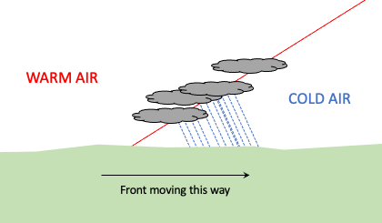
Draw a model depicting a warm front.
**warm air arrows should be pointing upwards, above the cold air**
100
Name two greenhouse gasses that are abundant in our atmosphere, leading to rising global temperatures
what are carbon dioxide and methane
100
This is the name of the planetary wind belt that influences the movement of air masses across the United States.
What is the Westerlies
200
This type of pressure system moves counterclockwise and inwards, in the northern hemisphere.
What is low pressure
200
According to the station model, how fast is the wind blowing at this location?
What is 30 knots
200
As two air masses collide, where do we experience rain?
AT the front. Not behind or in front of the front.
200
This human activity is causing a rise in carbon dioxide levels in our atmosphere.
What is burning fossil fuels/nonrenewable energy sources
200
This ocean current brings warm ocean waters to the southern tip of Africa
What is the Agulhas Current
300
Draw a high pressure center, and 4 arrows showing the direction of air movement.

300
Observe the following station model. What weather symbol would be appropriate to add, based on the details given?
any weather symbol that involves precipitation that is snow, sleet, hail or freezing.
300
Name a location where an mT air mass may form.
Anywhere wet and warm; Gulf of Mexico, Pacific Ocean near the equator, Caribbean, etc.
300
This human activity reduces the amount of carbon dioxide being removed from our atmosphere
What is deforestation
300
At 60 degrees South, the polar easterlies blow in what direction?
What is east to west
400
Winds blow from
high pressure to low pressure
400
This symbol is used to describe light freezing drizzle.

400
This map symbol is used to describe an air mass whose source region is over Canada.
What is cP (continental polar): dry and cold
400
What is the temporal scale of global climate change? Days, weeks, years, decades etc?
What are decades to centuries and beyond!
400
This convection cell consists of rising air at low pressure latitudes, and sinking air at high pressure latitudes
What is the Hadley Cell OR Polar Cell
500
This process describes why low pressure days are lousy, rainy days.
On low pressure days, air rises. As air rises higher into the atmosphere it cools down, causing condensation which creates clouds, eventually leading to rain.
500
Draw a station model that includes the following information:
temp: 75F
dew point: 73F
sky cover: 75%
sea-level pressure: 950.1mb
weather: heavy, rainy thunderstorms
wind: SW 15 knots
**with a dot on top, and the arrow pointing down towards the left**
500
This symbol is used to show an occluded front advancing towards the east.
**arrows should be pointing towards the east**
500
Provide an example of a positive feedback loop that increases global temperatures.
Several answers acceptable, the initial cause must be increased by the result.
500
This ocean gyre moved clockwise in the Northwestern Hemisphere
What is the North Pacific Ocean Gyre OR North Atlantic Ocean Gyre