Basic Weather
Weather Patterns
Climate
Reading Weather Maps
Climate Change.. ahh!
100
Clouds are made up of tiny drops of ______ or ice.
water
100
This symbol indicates a __________.

cold front
100
Lines of ________ are what determines climate areas or zones.

LATITUDE
100
In the next 24hours, what type of pressure system do you expect to reach Albany NY?
LOW PRESSURE
100
This image shows natural....
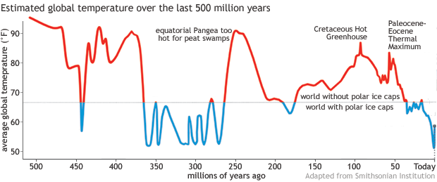
CLIMATE CHANGE
200
This is the daily change causing sunny days, cloudy days, rain, etc.
Weather
200
This symbol indicates a warm front and can cause storms when associated with this pressure system.

LOW PRESSURE
200
What Peanuts character is always playing the piano?
SCHROEDER
200
What type of pressure system is occurring over South Florida on this day based on the map.
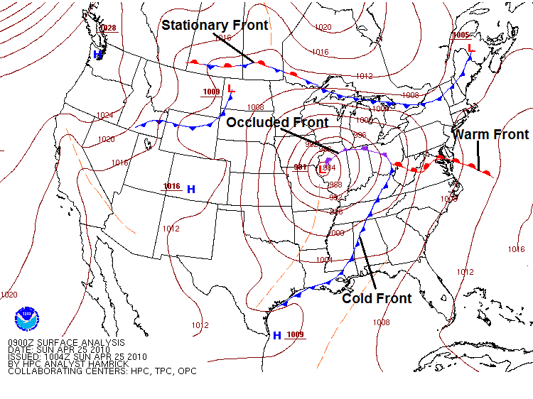
HIGH PRESSURE
200
Dakota is super into tractors. What is his favorite kind?
JOHN DEERE
300
Pixar or Disney produced? Toy Story
PIXAR
300
This symbol indicates ...

occluded front
300
In the USA, winds travel from _______ to ______.
west to east
300
T/F: Climate is the day to day changes based on location.
FALSE
300
The average temperature of the surface of Earth has increased approximately 1°C in the past century mainly due to ...
greenhouse gases, fossil fuels, carbon dioxide
400
These are the three parts of the water cycle.
evaporation, condensation, precipitation
400
This type of pressure system causes _______ air to ________ as shown in the image. 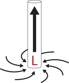
warm, rise
400
This is the largest island in the world.
GREENLAND
400
This is the type of map shown that shows pressure (the lines on the map)
ISOBAR
400
In the movie Happy Gilmore, what sport did he play before playing golf?
HOCKEY
500
T/F: Weather patterns are generally caused by winds traveling east to west.
False
500
High air pressure systems generally drive ________ air towards the ground.
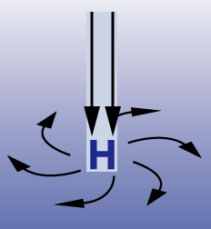
cool
500
These are some of the global features are some of the factors that cause weather conditions.
oceans, greenhouse effect, wind, pressure
500
This is the driving factor that causes the coasts to be warmer than the middle of the country.
OCEAN, or OCEAN CURRENTS
500
This is the term for the climate impact that is caused when water vapor in the air mixes with airpollution, causing nitric and sulfuric acid.
ACID RAIN