Overview of hazards #1
Miscellaneous definitions
Natural hazards
Mapping skills
Ecological hazards
Random stuff
Overview of hazards #2
100
Define the term hydrological hazard, using an example.
- Potential risks involving the movement of water due to processes within the water cycle.
- Floods are the most frequently occurring natural hazard.
- 2022 eastern Australia floods occurred over 2 months, resulting in 27 deaths.
100
Describe how you might categorise the following hazard:
A large Category 5 cyclone (Yasi) crossed the Queensland coastline on 3 February 2011 causing $800 million in agricultural damage.
![]()
- Natural, atmospheric hazard.
100
Which factor influences the magnitude of a bushfire?
a) Wind speed
b) Soil moisture
c) Humidity levels
d) Cloud cover
a) Wind speed
100
Identify the three pieces of information shown by contour lines.
- Shape of the land
- Slope of the land
- Height of the land
100
Which factor contributes most to the high probability of contracting malaria in certain regions?
a) Cold climates
b) Low humidity levels
c) Presence of Anopheles mosquitoes
d) High altitude areas
c) Presence of Anopheles mosquitoes
100
What is the following information providing?
Perth CBD is located on the northern banks of the Swan River on relatively flat land ranging from 0m to 25m above sea level.
Site characteristics:
- Drainage pattern
- Topography
100
Describe how you might categorise the following hazard:
On 20 April 2010, the largest marine oil spill occurred in the Gulf of Mexico from the Deepwater Horizon oil rig.- Ecological, chemical hazard.
200
Outline invasive species in relation to ecological hazards.
- A biological hazard driven by biological processes associated with life forms that has the potential to negatively impact the wellbeing of people or the environment.
- South American cane toads were introduced in Queensland in 1935 to control sugarcane beetles. They are considered the worst invasive species in Australia due to how quickly they multiply, spread and poison.
200
The extent of an area that is impacted by a hazard.
Scale of spatial impact.
200
What is a primary natural cause of bushfires?
a) Earthquakes
b) Lightning strikes
c) Volcanic eruptions
d) Tsunamis
b) Lightning strikes
200
Identify the three types of scale used to describe a topographic map.
*Double points if you can define scale.
- Ratio scale
- Linear scale
- Written representation
Definition: The scale on a topographic map refers to the relationship between distances on the map and the actual distances on the ground.
200
In which type of region is malaria most likely to have a widespread spatial impact?
a) Temperate regions with seasonal rainfall
b) Tropical and subtropical regions
c) Polar regions
d) Desert regions
b) Tropical and subtropical regions
200
This method is an analytical approach used to examine data or sources. It involves identifying regularities or recurring themes, measuring and providing numerical evidence to support these observations, and then identifying any anomalies or outliers that do not fit the established regularities.
PQE method
200
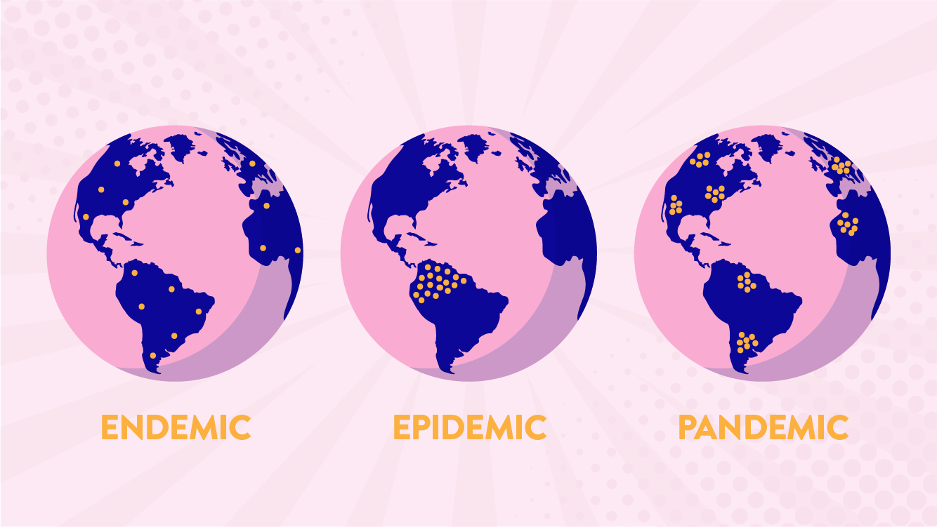
The occurrence of more cases of disease than expected in a given area or among a specific group of people over a particular period of time.
Epidemic.
300
Define the concept of ecological hazard.
- Any natural or human-made biological or chemical risk that has the potential to negatively impact people or the environment.
- Biological hazards (life forms) include infectious, animal-transmitted, water-borne diseases and invasive plant/animal species.
- Human-induced hazards involve chemical agents such as oil spills or nuclear waste.
300
The difference in height between two adjacent contour lines.
Contour interval
300
How do bushfires impact local economies?
a) Stimulating tourism
b) Boosting agricultural productivity
c) Damaging infrastructure and property
d) Attracting foreign investment
c) Damaging infrastructure and property
300
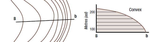
When the spacing between contour lines (reading from high to low) decreases, what shape is the slope?
Convex
300
Which environmental condition is least likely to contribute to malaria transmission?
a) Warm temperatures
b) High humidity
c) Stagnant water bodies
d) Dry, arid conditions
d) Dry, arid conditions
300
This is calculated by measuring the angle from north in a clockwise direction.
Bearing
300
Explain the concept of mitigation in relation in a natural hazard.
- First step in hazard management.
- Actions taken in advance of a disaster to minimise or eliminate the severity of a hazard.
- Three factors should be considered: geographic extent, spatial variations & probability.
- Authorities must constantly learn after every hazard event.
- Mitigation strategy for bushfires: prescribed burning which is the intentional, planned, low-intensity burning of an area to reduce fuel loads.
400
Define the concept of natural hazard.
- A naturally occurring event or phenomenon that has the potential to cause harm to human life, property, and the environment.
- Categorised as geomorphic, hydrological and atmospheric.
- Include earthquakes, floods, hurricanes, volcanic eruptions, and other extreme weather conditions or geological processes.
- Has the potential to lead to significant social, economic, and environmental impacts, especially in areas that are vulnerable due to factors like geography, infrastructure, and preparedness levels.
400
The arrangement of geographical phenomena or activities across the Earth's surface.
Spatial distribution.
400
How does urban sprawl contribute to the severity of bushfires?
a) Decreasing fuel load
b) Reducing population density
c) Encroaching on natural vegetation
d) Enhancing firefighting capabilities
c) Encroaching on natural vegetation
400
Identify the landform feature represented below.
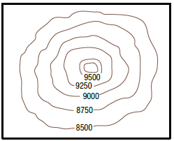
*Double points: identify the contour interval.
Mountain.
250m.
400
Which of the following is an economic impact of malaria?
a) Deforestation
b) School absenteeism
c) Increased healthcare costs
d) Loss of biodiversity
c) Increased healthcare costs
400
How can you identify the flame heights of a bushfire?
Scorch marks are 5x higher than flame height.
400
Explain the concept of preparedness in relation in an ecological hazard.
- planning the interventions required to prevent the effects of the hazard, including being able to respond to and cope effectively with the impacts.
- Emergency services and people at risk are aware of how to respond during a hazard event.
- Examples include: public education, food reserves, equipment, water and medicines stored and development of emergency/evacuation plans.
500
Define the concept of hazard geography.
- The study of both natural and ecological hazards, such as earthquakes, storms, diseases or oil spills.
- Where, why, how they occur.
- Impacts they have.
- How human can minimise the risk.
500
Which essential term is being discussed below:
The 2021 Wooroloo bushfire in Western Australia burned for over a week, with the fire first reported on 1 February and waws classified as 'contained and controlled' on 8 February.
*Double points for a definition.
Duration.
Definition: The actual length of time that the hazard event occurs.
500
Categorise community education as a hazard risk management strategy to reduce the impacts of bushfires.
- Preparedness strategy.
- Community education and preparedness programs aim to increase public awareness of bushfire risks, teach individuals about bushfire safety measures, and promote early evacuation plans.
- These programs often include training sessions, distribution of informational materials, and community drills to ensure readiness in the event of a bushfire.
500
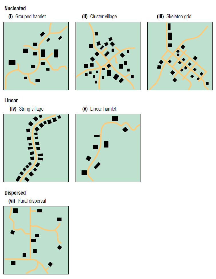
List the three main settlement patterns of a built-up area.
- Nucleated
- Linear
- Dispersed
500
Which human activity is most likely to create additional breeding sites for mosquitoes, thereby increasing malaria transmission?
a) Use of solar energy
b) Irrigation and standing water
c) Recycling programs
d) Construction of wind farms
b) Irrigation and standing water
500
Which Plasmodium parasite is primarily responsible for the most severe cases of malaria?
a) Plasmodium malariae
b) Plasmodium ovale
c) Plasmodium vivax
d) Plasmodium falciparum
d) Plasmodium falciparum
500
The strength of a hazard, or how large and important a natural hazard event is.
*Double points for an example of measure.
Magnitude.
Example:
- the Richter scale for earthquakes
- Volcanic explosivity index (VEI)
- number of deaths or infected for ecological hazards
600
Define the concept of geomorphic hazards.
- Potential dangers created by the movement of the Earth's crust, typically due to tectonic forces.
- These forces cause movement within the Earth's crust from convection currents within the Earth.
- Examples include earthquakes, tsunamis and volcanoes.
600
The degree to which a community is likely to experience harm due to exposure to hazards. It is influenced by physical factors (such as geographical location and infrastructure quality) and human factors (such as economic status, governance, education, and access to resources), making less developed countries often more susceptible to greater impacts from these hazards compared to more developed countries.
Vulnerability.

600
Which human activity can increase the intensity of bushfires?
a) Controlled burning
b) Fire breaks construction
c) Poor waste management
d) Early warning systems
c) Poor waste management
600
Determine the gradient of the slope from C to D.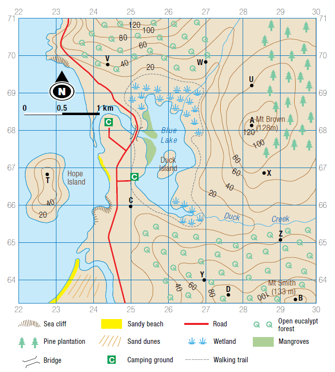
1:22
600
What is a major challenge associated with indoor residual spraying (IRS) as a malaria control strategy?
a) Low cost and easy application
b) Potential for insecticide resistance
c) High acceptance by all communities
d) Complete elimination of mosquitoes
b) Potential for insecticide resistance
600
The following map used spatial technology to show the climatic variables and malarial risk in Africa. It provides an accurate image of the distribution of malaria and the people impacted by this disease, which then can assist agencies in disease control. Which type of spatial technology was used to produce this source?

GIS!
Map + data = GIS
600
Describe the role of spatial technologies in the study of natural and ecological hazards.
*Bonus points for an explanation of one (1) form of spatial tech.
Spatial technology is both software and hardware vital in the study and management of hazards. It provides tools for hazard mapping, real-time monitoring, risk assessment, and disaster response. Spatial technologies enable precise location tracking, data collection, and spatial analysis, which are essential for identifying hazard-prone areas, predicting potential disasters, and planning effective mitigation strategies. Assists in the coordination of response activities and enhancing public awareness through accessible risk information.
- Global Positioning System (GPS) - once connected to the network of satellites that circle the Earth, this provides an exact location on Earth (using Lat/Long coordinates).
- Geographic Information Systems (GIS) - analyses and visualises spatial data using various data sources.
- Remote sensing - allows data to be collected about the Earth without being in contact with the Earth. For example: aerial photographs & satellite images.